
A mountain famous in Scripture, and highly celebrated: it separates Syria from Palestine. The name in Hebrew is Leban, and signities white, - - probably so called from the everlasting snow covering the summit or it. The cedars of Lebanon, and the streams from Lebanon, are spoken of in highly figurative language, to intimate the blessings in Christ. Hence the spouse in the Canticles speaks of Jesus as "a fountain of gardens, a well of living waters, and streams from Lebanon." (Song 4: 15.) And the idea is as beautiful as thefigureis just and correct: for as the cold flowing waters which descend from the mountain of Lebanon refresh the earth, and cool the hot climate, and are very copious, and run with rapidity; so the grace of God in Christ Jesus, like the water of life, runs freely, graciously, and abundantly, to make "glad the city of God." So Christ himself is said to be "as rivers of water in a dry place, and as the shadow of a great rock in a weary land." (Isa. xxx2: 2.) Hence the prophet, exclaiming against the folly of Israel’s leaving the Lord, saith, Will a man leave the snow of Lebanon which cometh from the rock of the field; or shall the cold flowing waters that come from another place be forgotten?" (Jer. 18: 14.)
or LIBANUS, signifying white, from its snows,—the most elevated mountain or mountain chain in Syria, celebrated in all ages for its cedars; which, as is well known, furnished the wood for Solomon’s temple. This mountain is the centre, or nucleus, of all the mountain ridges which, from the north, the south, and the east, converge toward this point; but it overtops them all. This configuration of the mountains, and the superiority of Lebanon, are particularly striking to the traveller approaching both from the Mediterranean on the west. and the desert on the east. On either side, he first discovers, at a great distance, a clouded ridge, stretching from north to south, as far as the eye can see; the central summits of which are capped with clouds, or tipped with snow. This is Lebanon, which is often referred to in Holy Writ for its streams, its timber, and its wines; and at the present day the seat of the only portion of freedom of which Syria can boast.
The altitude of Lebanon is so considerable, that it appears from the reports of travellers to have snow on its highest eminences all the year round. Volney says, that it thus remains toward the north-east, where it is sheltered from the sea winds and the rays of the sun. Maundrell found that part of the mountain which he crossed, and which in all probability was by no means the highest, covered with deep snow in the month of May. Dr. E. D. Clarke, in the month of July, saw some of the eastern summits of Lebanon, or Anti-Libanus, near Damascus, covered with snow, not lying in patches, as is common in the summer season with mountains which border on the line of perpetual congelation, but do not quite reach it, but with that perfect white, smooth, and velvet-like appearance, which snow only exhibits when it is very deep,—a striking spectacle in such a climate, where the beholder, seeking protection from a burning sun, almost considers the firmament to be on fire. At the time this observation was made, the thermometer, in an elevated situation near the sea of Tiberias, stood at 102½ in the shade. Sir Frederic Henniker passed over snow in July; and Ali Bey describes the same eastern ridge as covered with snow in September. Of the noble cedars which once adorned the upper parts of this mountain but few now remain, and those much decayed. Burckhardt, who crossed Mount Libanus in 1810, counted about thirty-six large ones, fifty of middle size, and about three hundred smaller and young ones: but more might exist in other parts of the mountain. The wine, especially that made about the convent of Canobin, still preserves its ancient celebrity; and is reported by travellers, more particularly by Rauwolff, Le Bruyn, and De la Roque, to be of the most exquisite kind for flavour and fragrance. The rains which fall in the lower regions of Lebanon, and the melting of the snow in the upper ones, furnish an abundance of perennial streams, which are alluded to by Solomon, Son 4:15. On the declivities of the mountain grew the vines which furnished the rich and fragrant wine which Hosea celebrated, Hos 14:7, and which may still be obtained by proper culture.
The cedar of Lebanon has, in all ages, been reckoned as an object of unrivalled grandeur and beauty in the vegetable kingdom. It is, accordingly, one of the natural images which frequently occur in the poetical style of the Hebrew prophets; and is appropriated to denote kings, princes, and potentates of the highest rank. Thus, the Prophet Isaiah, whose writings abound with metaphors and allegories of this kind, in denouncing the judgments of God upon the proud and arrogant, declares that “the day of the Lord of Hosts shall be upon all the cedars of Lebanon that are high and lifted up, and upon all the oaks of Bashan,” Isa 2:13. The king of Israel used the same figure in his reply to the challenge of the king of Judah: “The thistle that was in Lebanon sent to the cedar that was in Lebanon, saying, Give thy daughter to my son to wife: and there passed by a wild beast that was in Lebanon, and trod down the thistle,” 2Ki 14:9. The spiritual prosperity of the righteous man is compared by the Psalmist to the same noble plant: “The righteous shall flourish as the palm- tree; he shall grow as the cedar in Lebanon.” To break the cedars, and shake the enormous mass on which they grow, are the figures that David selects to express the awful majesty and power of Jehovah: “The voice of the Lord is powerful; the voice of the Lord is full of majesty. The voice of the Lord breaketh the cedars: yea, the Lord breaketh the cedars of Lebanon. He maketh them also to skip like a calf; Lebanon and Sirion like a young unicorn,” Psa 29:4-6. This description of the divine majesty and power possesses a character of awful sublimity.
The stupendous size, the extensive range, and great elevation of Libanus; its towering summits capped with perpetual snow, or crowned with fragrant cedars; its olive plantations; its vineyards, producing the most delicious wines; its clear fountains, and cold-flowing brooks; its fertile vales, and odoriferous shrubberies,—combine to form in Scripture language, “the glory of Lebanon.” But that glory, liable to change, has, by the unanimous consent of modern travellers, suffered a sensisible decline. The extensive forests of cedar, which adorned and perfumed the summits and declivities of those mountains, have almost disappeared. Only a small number of these “trees of God, planted by his almighty hand,” which, according to the usual import of the phrase, signally displayed the divine power, wisdom, and goodness, now remain. Their countless number in the days of Solomon, and their prodigious bulk, must be recollected, in order to feel the force of that sublime declaration of the prophet: “Lebanon is not sufficient to burn, nor the beasts thereof sufficient for a burnt-offering,”
Isa 40:16. Though the trembling sinner were to make choice of Lebanon for the altar; were to cut down all its forests to form the pile; though the fragrance of this fuel, with all its odoriferous gums, were the incense; the wine of Lebanon pressed from all its vineyards, the libation; and all its beasts, the propitiatory sacrifice; all would prove insufficient to make atonement for the sins of men; would be regarded as nothing in the eyes of the supreme Judge for the expiation of even one transgression. The just and holy law of God requires a nobler altar, a costlier sacrifice, and a sweeter perfume,—the obedience and death of a divine Person to atone for our sins, and the incense of his continual intercession to secure our acceptance with the Father of mercies, and admission into the mansions of eternal rest. The conversion of the Gentile nations from the worship of idols and the bondage of corruption, to the service and enjoyment of the true God, is foretold in these beautiful and striking terms: “The wilderness and the solitary place shall be glad for them: and the desert shall rejoice, and blossom as the rose. It shall blossom abundantly, and rejoice even with joy and singing; the glory of Lebanon shall be given unto it, the excellency of Carmel and Sharon: they shall see the glory of the Lord. and the excellency of our God.” Isa 35:4.
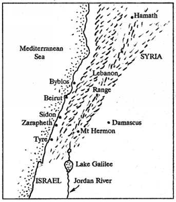
Leb´anon, a long chain of mountains on the northern border of Palestine. The term Libanus is more convenient in use than the Hebrew form Lebanon, as enabling us to distinguish the parallel ranges of Libanus and Anti-Libanus, which have no such distinctive names in connection with the Hebrew designation. Lebanon seems to be applied in Scripture to either or both of these ranges; and we shall also use it in this general sense: but Libanus means distinctively the westernmost of those ranges, which faces the Mediterranean, and Anti-Libanus the eastern, facing the plain of Damascus; in which sense these names will be used in this article. The present inhabitants of the country have found the convenience of distinguishing these parallel ranges; and give to Libanus the name of ’Western Mountain’ (Jebel esh-Sharki), and to Anti-Libanus that of ’Eastern Mountain’ (Jebel el-Gharbi); although Jebel Libnan (the same name in fact as Lebanon) occurs among the Arabs with special reference to the eastern range.
These two great ranges, which together form the Lebanon of Scripture, commence about the parallel of Tripoli (lat. 34° 28′), run in a general direction from N.E. to S.W., through about one degree of latitude, and form, at their southern termination, the natural frontier of Palestine. These parallel ranges enclose between them a fertile and well-watered valley, averaging about fifteen miles in width, which is the Cœle-Syria (Hollow Syria) of the ancients, but is called by the present inhabitants, by way of pre-eminence, el-Bekaa, or ’the Valley,’ which is watered through the greater portion of its length by the river Litany, the ancient Leontes.
Nearly opposite Damascus the Anti-Libanus separates into two ridges, which diverge somewhat, and enclose the fertile Wady et-Teim. The easternmost of these two ridges, which has already been pointed out as the Hermon of Scripture [HERMON], Jebel esh-Sheikh, continues its S.W. course, and is the proper prolongation of Anti-Libanus. From the base of the higher part of this ridge, a low broad spur or mountainous tract runs off towards the south, forming the high land which shuts in the basin and Lake of el-Huleh on the east. This tract is called Jebel Heish, the higher portion of which terminates at Tel el-Faras, nearly three hours north of Fiek. The other ridge of Anti-Libanus takes a more westerly direction. It is long, low, and level; and continues to border the lower part of the great valley of Bekaa, until it seems to unite with the higher bluffs and spurs of Lebanon, and thus entirely to close that valley. In fact, only a narrow gorge is here left between precipices, in some places of great height, through which the Litany finds its way down to the sea, north of Tyre. The chain of Lebanon, or at least its higher ridges, may be said to terminate at the point where it is thus broken through by the Litany. But a broad and lower mountainous tract continues towards the south, bordering the basin of the Huleh on the west. It rises to its greatest elevation about Safed (Jebel Safed); and at length ends abruptly in the mountains of Nazareth, as the northern wall of the Plain of Esdraelon. This high tract may very properly be regarded as a prolongation of Lebanon.
The mountains of Lebanon are of limestone rock, generally of a whitish hue, and from the aspect which the range thus bears in the distance, in its cliffs and naked parts, the name of Lebanon (which signifies ’white’) has been supposed to be derived; but others seek its origin in the snows which rest long upon its summits, and perpetually upon the highest of them.
Of the two ranges, that of Libanus is by far the highest. Its uppermost ridge is marked by a line, drawn at the distance of about two hours’ journey from the summit, above which all is barren; but the slopes and valleys below this line afford pasturage, and are capable of cultivation, by reason of the numerous springs which are met with in all directions. Cultivation is, however, chiefly found on the seaward slopes, where numerous villages flourish, and every inch of ground is turned to account by the industrious natives, who, in the absence of natural levels, construct artificial terraces in order to prevent the earth from being swept away by the winter rains, and at the same time to retain the water requisite for the irrigation of the crops. When one looks upward from below, the vegetation on these terraces is not visible; so that the whole mountain appears as if composed only of immense rugged masses of naked whitish rock, traversed by deep wild ravines, running down precipitously to the plain. No one would suspect among these rocks the existence of a vast multitude of thrifty villages and a numerous population of mountaineers, hardy, industrious, and brave. Here, amid the crags of the rocks, are to be seen the remains of the renowned cedars; but a much larger proportion of firs, oaks, brambles, mulberry-trees, fig-trees, and vines.
Although the general elevation of Anti-Libanus is inferior to that of Libanus, the easternmost of the branches into which it divides towards its termination (Jebel esh-Sheikh) rises loftily, and overtops all the other summits of heaven. Our information respecting Anti-Libanus is less distinct than that concerning the opposite range. It appears, however, that it has fewer inhabitants, and is scarcely in any part cultivated.
None of the summits of Libanus or Anti-Libanus have been measured. By comparing the accounts of different travelers, however, as to the continuance of snow upon the higher summits, and adjusting them with reference to the point of perpetual congelation in that latitude, a rough estimate may be formed, that the average height of the Libanus mountains, from the top of which the snow entirely disappears in summer, must be considerably below 11,000 feet, probably about 10,000 feet above the level of the sea. But the higher points, particularly the Sannin, which is the highest of all, must be above that limit, as the snow rests on them all the year. By the same rule the average height of the Anti-Libanus range is reckoned as not exceeding 9000 feet; but its highest point, in the Jebel es-Sheik, or Mount Hermon, is considered to be somewhat more lofty than the Sannin, the highest point of Libanus.
In Scripture Lebanon is very generally mentioned in connection with the cedar-trees in which it abounded; but its wines are also noticed (Hos 14:7); and in Son 4:11; Hos 14:6, it is celebrated for various kinds of fragrant plants.
White, a long chain of mountains on the north of Palestine, so named from the whitish limestone of which they are composed and in part perhaps from their snowy whiteness in winter. It consists of two main ridges running northeast and southwest, nearly parallel with each other and with the coast of the Mediterranean. See view in SIDON. The western ridge was called Libanus by the Greeks, and the eastern AntiLibanus. Between them lies a long valley called Coele-Syria, that is, Hollow Syria, and the "valley of Lebanon," Jos 11:17, at present Bukkah. It opens towards the north, but is exceedingly narrow towards the south, where the river Litany, anciently Orontes, issues form the valley and flows west to the sea, north of Tyre. The western ridge is generally higher than the eastern, and several of its peaks are thought to be towards, 10,000 feet high. One summit, however, in the eastern range, namely, Mount Hermon, now called Jebel-esh-Sheikh, is higher still, and rises nearly into the region of perpetual ice. See HERMON. An Arab poet says of the highest peak of Lebanon, "The Sannin bears winter on his head, spring upon his shoulders, and autumn in his bosom, while summer lies sleeping at his feet."\par The Hebrew writers often allude to this sublime mountain range, Isa 10:34 35:2, rising like a vast barrier on their north, Isa 37:24 . They speak of its sea of foliage agitated by the gales, Psa 72:16 ; of its noble cedars and other trees, Isa 60:13 Jer 22:23 ; of its innumerable herds, the whole of which, however, could not atone for one sin, Isa 40:16 ; its snow-cold streams, Jer 18:14, and its balsamic perfume, Hos 14:5 . Moses longed to enter the Holy Land, that he might "see that goodly mountain and Lebanon," Deu 3:24,25 ; and Solomon says of the Beloved, the type of Christ, "his countenance is as Lebanon," Son 5:15 . "The tower of Lebanon which looketh towards Damascus," Son 7:4, is brought to recollection by the accounts given by modern travelers of the ruins of ancient temples, built of stones of vast size. Many such ruinous temples have been discovered in different parts of Lebanon, several of them on conspicuous points, high up in the mountains, where the labor of erecting them must have been stupendous.\par At present, Lebanon is inhabited by a hardy and turbulent race of mountaineers. Its vast wilderness of mountains forms almost a world by itself. Its western slopes particularly, rising by a succession of terraces from the plain of the coast, are covered with vines, olives, mulberries, and figs; and occupied, as well as the valleys among the mountains, by numberless villages. Anti-Lebanon are Drues and Maronites; the former Mohammedan mystics, and the latter bigoted Romanists. Among them are interspersed many Greeks and Armenians.\par For "cedar of Lebanon," see CEDAR.\par
Leb’anon. A mountain range in the north of Palestine. The name Lebanon signifies white, and was applied either , on account of snow which, during a great part of the year, cover its whole summit, or on account of the white color of its limestone cliffs and peaks. It is the "white mountain" -- the Mont Blane of Palestine. Lebanon is represented in Scripture as lying upon the northern border of the land of Israel. Deu 1:7; Deu 11:24; Jos 1:4.
Two distinct ranges bear this name. They run in parallel lines from southwest to northeast for about 90 geographical miles, enclosing between them a long, fertile valley from five to eight miles wide, anciently called Coele-Syria. The western range is the "Libanus" of the old geographers and the Lebanon of Scripture. The eastern range was called "Anti-Libanus" by geographers, and "Lebanon toward the sunrising" by the sacred writers. Jos 13:5.
Lebanon -- the western range -- commences on the south of the deep ravine of the Litany, the ancient river Leontes, which drains the valley of Cole-Syria, and falls into the Mediterranean five miles north of Tyre. It runs northeast in a straight line parallel to the coast, to the opening from the Mediterranean into the plain of Emesa, called in Scripture the "entrance of Hamath." Num 34:8. Here Nehr el-Kebir -- the ancient river Eleutherus -- sweeps round its northern end, as the Leontes does round its southern.
The average elevation of the range is from 6000 to 8000 feet; but two peaks rise considerably higher. On the summits of both these peaks, the snow remains in patches during the whole summer. The line of cultivation runs along at the height of about 6000 feet; and below this the features of the western slopes are entirely different. The rugged limestone banks are scantily clothed with the evergreen oak, and the sandstone with pines; while every available spot is carefully cultivated. The cultivation is wonderful, and shows what all Syria might be if under a good government. Fig trees cling to the naked rock; vines are trained along narrow ledges; long ranges of mulberries, on terraces like steps of stairs, cover the more gentle declivities; and dense groves of olives fill up the bottoms of the glens.
Hundreds of villages are seen -- here, built among labyrinths of rocks, there, clinging like among labyrinths of rocks, there, clinging like swallows’ nests to the sides of cliffs; while convents, no less numerous, are perched on the top of every peak. The vine is still largely cultivated in every part of the mountain. Lebanon also abounds in olives, figs and mulberries; while some remnants exist of the forests of pine, oak and cedar which formerly covered it. 1Ki 5:6; Ezr 3:7; Psa 29:5; Isa 14:8.
Considerable numbers of wild beasts still inhabit its retired glens and higher peaks; the writer has seen jackals, hyaenas, wolves, bears and panthers. 2Ki 14:9; Son 4:8; Hab 2:17. Along the base of Lebanon runs the irregular plain of Phoenicia -- nowhere more than two miles wide, and often interrupted by bold rocky spurs that dip into the sea.
The main ridge of Lebanon is composed of Jura limestone, and abounds in fossils. Long belts of more recent sandstone run along the western slopes, which are in places largely impregnated with iron. Lebanon was originally inhabited by the Hivites and Giblites. Jos 13:5-6; Jdg 3:3. The whole mountain range was assigned to the Israelites, but was never conquered by them. Jos 13:2-6; Jdg 3:1-3. During the Jewish monarchy it appears to have been subject of the Phoenicians. 1Ki 5:2-6; Ezr 3:7. From the Greek conquest until modern times, Lebanon had no separate history.
2. Anti-Libanus. -- The main chain of Anti-Libanus commences in the plateau of Bashan, near the parallel of Caesarea Philippi, runs north to Hermon, and then northeast in a straight line, till it stinks down into the great plain of Emesa, not far from the site of Riblah.
Hermon is the loftiest peak; the next highest is a few miles north of the site of Abila, beside the village of Bludan, and has an elevation of about 7000 feet. The rest of the ridge averages about 5000 feet; it is, in general, bleak and barren, with shelving gray declivities, gray cliffs and gray rounded summits.
Here and there, we meet with thin forests of dwarf oak and juniper. The western slopes descend abruptly into the Buka’a; but the features of the eastern are entirely different. Three side ridges here radiate from Hermon, like the ribs of an open fan, and form the supporting walls of three great terraces. Anti-Libanus is only once distinctly mentioned in Scripture, where it is accurately described as "Lebanon toward the sunrising." Jos 13:5.
"exceeding white", namely, with snow, as Mont Blanc. In Hebrew Lebanon, related to "alp". The double mountain range N. of Palestine, running in parallel lines from S.W. to N.E., having between the fertile valley anciently called Coelosyria, now El Beka’a (where are the grand ruins of the temple of the sun), about six or seven miles wide, "the valley of Lebanon" (Jos 11:17). The range is about 80 miles long, 15 broad. It forms the northern head of the Jordan valley and the southern head of the Orontes valley.
Lebanon runs parallel to the coast in the plain of Emesa opening from the Mediterranean, in Scripture "the entering in (i.e. entrance) of Hamath" (1Ki 8:75). The river Eleutherus (nahr el Kebir) here sweeps round its northern end. The average height is 7,000 ft. But one peak, Dhor el Khodib, N. of the cedars, is 10,051 ft.; and Hermon in Antilebanon is 10,125 ft.. Lebanon is of grey limestone, with belts of recent sandstone along the western slopes. Eastward in the glens of Antilibanus flow toward Damascus Abana (Barada) and Pharpar (nahr el Awaj). All that now represents Hiram’s cedar forests is the cluster called "the cedars," 6,172 ft. above the sea, in the center of the vast recess or semicircle formed by the highest summits of Lebanon above the deep valley of the sacred river Kadisha.
The line of cultivation runs at the height of 6,000 ft. Every available space is utilized for figtrees, vines, mulberry trees, and olives. Numerous villages nestle amidst the rocks. The trees striking their roots into the fissures of rocks illustrate Hos 14:5, "Israel shall strike forth his roots as Lebanon." Lebanon is a delightful retreat from the sultry heat of the plains and of Palestine, cooled as it is by the snows which crown its peaks. Jeremiah (Jer 18:14) asks, "will a man leave the snow of Lebanon which cometh from the rock of the field (a poetical name for Lebanon towering above the surrounding plain)? Or shall the cold flowing waters that come from another place (from the distant rocks) be forsaken?" None. Yet Israel forsakes Jehovah the living fountain, ever near, for broken cisterns. Hyaenas, panthers, jackals, wolves, and bears still haunt its glens and peaks (compare Son 4:8; 2Ki 14:9).
The river Adonis (nahr Ibrahim) springs from a cave beneath the high peak Sunnin. The plain of Phoenicia, two miles wide, runs at the base of Lebanon between it and the sea. The eastern slopes are less abrupt and fertile than the western. Maronite Christians people the northern part of the range; Druses abound more in the southern. Lebanon was assigned to Israel, but never conquered (Jos 13:2-6; Jdg 3:1-3). It was under the Phoenicians in Solomon’s time and subsequently (1Ki 5:2-6; Ezr 3:7). Antilibanus is less peopled than Lebanon, and has more wild beasts: Son 4:8, "look from the top of Amana, from ... Shenir and Hermon ... the lions’ den ... the mountains of the leopards," referring to the two higher peaks, Hermon, and that near the fountain of Abana, where panthers still are found. "The tower of Lebanon which looketh toward Damascus" is Hermon (Son 7:4).
Lebanon (lĕb’a-non), exceeding white. A double mountain range to the north of Palestine, consisting of a western chain, Lebanon proper, and an eastern. "Lebanon toward the sun-rising," Jos 13:5, called by classic writers Anti-Libanus, and enclosing a valley from five to eight miles broad—" the valley of Lebanon," Jos 11:17; called by classic writers Cœlo-Syria. The western range, the Lebanon proper, begins on the north near the banks of the Eleutherus, which passes through the plain of Emesa, the "entrance of Hamath," Num 34:8, to the Mediterranean, and runs for a distance of 90 geographical miles, in the direction from northeast to southwest, parallel with the Mediterranean, to the banks of the Litany, the ancient Leontes, which, draining Cœlo-Syria and breaking through the Lebanon by a wild gorge, enters the Mediterranean a few miles north of Tyre. The average height of this range is from 6000 to 8000 feet. "The smell of thy garments is like the smell of Lebanon." Son 4:11. The eastern chain, the Anti-Lebanon, runs nearly parallel with the western. Its highest point is Mount Hermon. Its western descent toward CœloSyria is abrupt and steep; to the east it gradually sinks into the plains of the desert. Its general aspect is bleak and barren, the abode of wild beasts and birds of prey. From both ranges numerous rivers descend—the Eleutherus, Leontes, Jordan, Abana, and Pharpar (which see); and the cold-flowing waters of the springs and streams of Lebanon were and are still proverbial.
[Leb’anon]
The mountain range in the north of Palestine. Its name signifies ’white,’ and may have arisen from some of its peaks being always covered with snow, or from the whiteness of its limestone cliffs. It is mentioned as the northern boundary of Palestine. Deu 1:7; Deu 11:24; Jos 1:4. There are two ranges bearing this name, the southern terminus of both being about 33° 23’ N. They run N.E. nearly parallel with the Mediterranean; a fertile valley, from five to eight miles wide, running between them. This is mentioned in Jos 11:17. Its modern name is El Bukeiah. The valley may be considered as being prolonged southward in the Jordan valley.
The western range is the Lebanon generally referred to in scripture and the one from whence Solomon obtained cedar and fir trees for the temple. 1Ki 5:8-9; Psa 29:5; Isa 14:8. Of the cedars only a few remain. There are many villages situated on the small plains on the mountains, with patches of grain growing here and there; vines also are cultivated from which excellent wine is made. Hos 14:7. Firs grow, clinging as it were to the bare rock, yet quite secure. Hos 14:5. Olives, figs, and mulberries also abound, and a number of aromatic shrubs, which perfume the air, as alluded to in Son 4:11. Wild beasts still inhabit the glens and peaks as they did in O.T. times. 2Ki 14:9; Son 4:8; Hab 2:17. Its modern name is Jebel Libnan.
The eastern range is often called ANTI-LEBANON, but in scripture it is alluded to as ’Lebanon toward the sun-rising.’ Jos 13:5. Its modern name is Jebel esh Shurky. Mount Hermon is its southern point. The road from Beyrout [Beirut] to Damascus crosses both the mountains of Lebanon.
( ):
):
By: Emil G. Hirsch, M. Seligsohn
Table of Contents
Proverbial Fertility.
Name of a range of mountains in Syria. In prose, with the exception of IIChron. ii. 8 (Hebr.), the name is always written with the article, while in poetry it occurs as often without as with the article. The name (= "white") is due either to the snow which covers its peaks for the greater part of the year, and to which Jer. xviii. 14 alludes, or to the calcareous formations of the upper ranges. The topography of the Lebanon is very vaguely indicated in the Bible; it appears only as the great northern limit of the land assigned to Israel (Deut. i. 7, xi. 24; Josh. i. 4), and is mentioned as being not far from the Sea of Joppa (Ezra iii. 7). It was fully described by Greek geographers, among others by Strabo (xvi. 754): it consists of two parallel ranges running south-southwest and north-northeast, the western range being called "Lebanon," and the eastern, "Anti-Lebanon"; Mt. Hermon is the highest peak in the latter range. Between the two ranges is a valley which the Bible calls "the valley of Lebanon," where the city of Baal-gad was situated (Josh. xii. 7); the Greeks gave the name "Cœle-Syria" to the district. The Lebanon juts into the Mediterranean south of Tyre, where the rocks form an ascent to the top of the mountain; hence the Talmudic name  (= "the ladder of Tyre"; Yer. 'Ab. Zarah i. 9; 'Er. 80a; Beẓah 25b; comp. the
Proverbial Fertility.
"Lebanon" also in the Bible includes the Anti-Lebanon (comp. Josh. xiii. 5, "all Lebanon toward the sunrising," and Cant. vii. 5 [A. V. 4], "the tower of Lebanon which looketh toward Damascus"; in both verses the Anti-Lebanon being meant). At the time of Joshua, the Lebanon was inhabited by the Hivites and Giblites, and though it formed a part of the land assigned to the Israelites it was never conquered by them (Josh. xiii. 5; Judges iii. 1-3). In the time of Solomon, the Lebanon district seems to have been in the possession of Hiram, King of Tyre (I Kings v. 6; II Chron. ii. 8). Nevertheless, Solomon appears to have erected buildings in the Lebanon (I Kings ix. 19; II Chron. viii. 6). Owing to its extraordinary fertility, the Lebanon is the mountain range most frequently mentioned in the Bible. Moses, when looking over the promised land, mentioned the Lebanon in particular (Deut. iii. 25). It was famous for its fruit (Ps. lxxii. 16), its wine (Hosea xiv. 8), and especially for its cedars, which furnished wood for the Temple (I Kings v. 6; Ezra iii. 7; Ps. xxix. 5, civ. 16; passim). The range had also an abundance of fir-trees and algum-trees (II Chron. ii. 8), and the thistle of the Lebanon is once referred to (ib. xxv. 18). The "smell of Lebanon" is spoken of in Hosea xiv. 7 and Cant. iv. 11, and by the Talmudists. "At the arrival of the Messiah, the young people of Israel will exhale an odor like that of Lebanon" (Ber. 43b). Lebanon is referred to as "Eden" by Ezekiel (xxxi. 16), and Isaiah speaks of the "glory of Lebanon" (Isa. lx. 13). It is for this reason that "Lebanon" is taken by the Prophets to designate Jerusalem (Isa. x. 34; Zech. xi. 1), while the Rabbis understood it to refer to the Temple of Jerusalem, supposing that it was so called because it cleanses Israel of sin (lit. "it whitened their sins"; Yoma 39a).
LEBANON, now Jebel Lebnân, is mentioned more than 60 times in the OT. The name, from the root lâbân (‘white’), was probably given on account of the mountain’s covering of snow. The snow of Lebanon is mentioned in Jer 18:14. Many passages refer to its beauty, particularly in relation to its cedars and other trees (see Psa 72:16, Son 4:11, Hos 14:5; Hos 14:7). From Lebanon was obtained wood for building the first (2Ch 2:8) and the second (Ezr 3:7) Temple. Lebanon was famous for its fruitfulness (Psa 72:16) and its wine (Hos 14:7).
The term ‘Lebanon’ may be considered in most places as referring to the whole mountain mass, more correctly distinguished as Lebanon and Anti-Lebanon (Libanus and Antilibanus of Jdt 1:7). The two ranges traverse N. Syria, running roughly parallel, from S.W. to N.E., and are separated by a deep valley—the biq‘ah of Jos 11:17; Jos 12:7—known to-day as el-Buqa. The western range, Lebanon proper, is nearly 100 miles long, but the eastern, if Hermon is deducted as a separate entity, is only 65 miles long. The former range is divided from the mountains of Galilee by the deep chasm made by the Litâni river in its passage seawards. In the N. a somewhat similar gorge formed by the Nahr el-Kebîr, the ancient Eleutherus, divides it from the Jebel Nusairiyeh. The summits of the range rise in height from south to north. In the S. a few points attain to almost 7000 feet; in the centre, E. of Beyrout, Jebel Kuneiseh is 6960 feet, and Jebel Sannîn 8554 feet; further N., to the S.E. of Tripoli, is a great semicircular group of mountains, sometimes known as the ‘Cedar group,’ on account of the famous group of these trees in their midst, where the highest point, Jebel Mukhmal, reaches 10, 207 feet, and several other points are almost as lofty. Geologically the Lebanon is built of three main groups of strata. Lowest comes a thick layer of hard limestone, named—after its most characteristic fossil (Cidaris glandaria)—Glandaria limestone; above this are strata of Nubian sandstone, yellow and red in colour, and in places 1500 feet thick, overlaid and interlaced with strata of limestone containing fossil echinoderms and ammonites; and thirdly, above this group, and forming the bulk of the highest peaks, is another layer, many thousand feet thick in places, of a limestone containing countless fossils known as hippurites, radiolites, and such like. The sandstone strata are most important, for where they come to the surface is the richest soil and the most plentiful water, and here flourish most luxuriantly the pines which are such a characteristic feature of W. Lebanon scenery. A great contrast exists between the W. and E. slopes. The former are fertile and picturesque, while down their innumerable valleys course numberless mountain streams to feed the many rivers flowing seawards. The E. slopes are comparatively barren, and, except at one point, near Zahleh, there is no stream of importance. Of the Lebanon rivers besides the Nahr Litâni (Leontes) and the Nahr el-Kebîr (Eleutherus), the following may be enumerated from S. to N. as the more important: Nahr ez-Zaherani, Nahr el-‘Auwali (Bostrenus), Nahr Beirût (Magoras), Nahr el-Kelb (Lycus), Nahr Ibrahîm (Adonis), and the Nahr Qadîsha or ‘holy river,’ near Tripoli.
The Lebanon is still fairly well wooded in a few places, though very scantily compared with ancient times, when Hiram, king of Tyre, supplied Solomon with ‘cedar trees, fir trees, and algum trees out of Lebanon’ (1Ki 5:6, 2Ch 2:8). In regard to cultivation there has been a very great improvement in recent years, and the terraced lower slopes of the mountain are now covered with mulberry, walnut, and olive trees as well as vines. Many of the views in the Lebanon are of most romantic beauty, and the climate of many parts is superb. Wild animals are certainly scarcer than in olden days. In the time of Tiglath-pileser 1. the elephant was hunted here, but it has long been extinct. Jackals, gazelles, hyænas, wolves, bears, and panthers (in order of commonness) are found and, inland from Sidon, the coney (Hyrax) abounds.
Politically the Lebanon rejoices in a freer and better government than any other part of Syria, as, since the massacres of 1860, a Christian governor, appointed with the approval of the European Powers, rules on behalf of the Sultan. The district, except in the N., is now extensively supplied with excellent carriage roads, and the range is crossed by the French railway from Beyrout to Damascus, the highest point traversed being 4880 feet above sea-level.
Between the Lebanon and Anti-Lebanon is the great hollow known to the Greeks as Cœle-Syria, and to-day called Buqa‘ el-‘Azîz. Considered geologically, this wide valley is a product of the same great ‘fault’ as produced the deep Jordan valley. It is now a great, fertile, but little cultivated, plain, from 3 to 6 miles wide, and in its rise, not far from Baalbek, two famous rivers, the Litâni (Leontes), which flows S., and the Nahr el-Asi or Orontes, which flows N., and enters the sea near Antioch. This hollow plain, besides being crossed transversely by the Damascus railway and road, is traversed over more than half its length by the new line past Baalbek, Homs, and Hamath to Aleppo Some part of this plain, ‘the valley of the Lebanon, would appear to have been conquered by the Israelites (Jos 11:17).
The Anti-Lebanon is to-day known as Jebel esh-Sherki or ‘the east mountain,’ the equivalent of ‘Lebanon towards the sun-rising’ of Jos 13:5. In Son 7:4 it is referred to as ‘the tower of Lebanon that looketh towards Damascus.’ In Deu 1:7; Deu 3:25; Deu 11:24, Jos 1:4; Jos 9:1, the Heb. ‘Lebanon’ is in the LXX
E. W. G. Masterman.
(Semitic root, laban)
Mountain, Syria, so called from the snow which covers the highest peaks during almost the entire year, or from the limestone which glistens white in the distance. It is the center of the great mountain range of central Syria, which is about 95 miles long, and consists of two parallel mountain chains of the same formation; the western, or Lebanon proper, and the eastern, or Antilibanus. In the latter, Mount Hermon reaches the height of 9300 feet Lebanon is often mentioned poetically in the Old Testament (Osee 14; Nahum 1), and is noted for its abundance of wood, especially the cedar (Zachariah 11; 1 Esdras 3), which was used by Solomon in building the Temple (3 Kings 5).
Lebanon (Assyr. Labn nu; Heb. Lebanôn; Egypt. possibly, Ramunu; Gr. Libanos), modern Jebel Libnân, or "White Mountain" (Semitic root laban), so called from the snow which covers the highest peaks during almost the entire year, or from the limestone which glistens white in the distance.The centre of the great mountain range of Central Syria, which stretches from N.N.E. to S.S.W. almost parallel with the sea for about 95 miles from 33°20’ to 34°40’ is separated in the south by the Qâsimiye from the Galilean hill-country; in the north, by the Nahr el-Keb r from Jebel el-Ansarieh. It consists of two parallel mountain chains of the same formation: the western, or Lebanon proper, called Jebel el-gharbi; the eastern, known as Jebel el-sharqi (the Antilibanus of the Greeks). The primeval mass was cleft asunder towards the end of the Tertiary formation (Pliocene), forming the northern part of the Jordan fissure, which extends southward to the Red Sea. Geologically there are four strata, which are easily distinguishable in the deeply rent ravines. The first stratum, consisting of a layer of limestone (Araya limestone), about 980 feet in thickness, is sparingly strewn with fossils (cidaris glandaria, corals and sponges), and belongs to the Cenoman, earliest of the Upper Jura. Above it lies a richly fossilized composite (Cephalopoda) of sandstone, from 650 to 1630 feet in thickness, and clay marl divided by layers of chalky deposit (Trigonia or Nubian sandstone) from the Cenoman. Basaltic masses of lava appear in the sandstone. Peat, iron ore, and traces of copper are also found, and fossilized resin in the coal schists. The third layer of Lebanon limestone (about 3580 feet thick) is characterized at the base by abundant oyster beds or by hippurite limestone (Cenoman-Turon). One peculiarity is the slate of Hakel, containing fossil fishes, found also in the marly limestone of Sâhil Alma. In Antilibanus (the Beq&aacirc;’a), and on the outer edges of Lebanon, a fourth stratum of Senonian (not over 330 feet in thickness) appears in flinty chalk and limestone.The highest peaks of these mountains are in the Western chain. They rise in the Arz Libnân to a height of more than 9800 feet, as Dahr el-Qodib; Jebel Makmal; Dahr el-Dubab (Qarn Sauda), about 10,000 feet. Exact measurements are wanting. Towards the south the elevation is not so great: Jebel-el Muneitira, 9130; Jebel Sannin, 8500 feet. In Antilibanus the Tala` at Mûsa is 8710 feet in height; Hermon, 9300. Deposits due to glacier formations may be observed at the top, but no one has as yet reached the actual snow line. Between Lebanon and Antilibanus extends the table-land of Beqâ’a, 5 to 9 miles broad, about 70 miles long, never rising to any height, considered by many the true Coelig;lesyria. The plain of Lebanon (D.V. Libanus) mentioned in Jos., xi, 17, and xii, 7, is probably Merj ’Aiyun. The southern and central parts are very fertile to-day. Near Ba albek is the watershed (about 3800 feet) between south and north, between the Nahr el-`Asi (Orontes) and the Nahr el-Lîtâni (not the Leontes), which latter as Nahr el-Qâsimiye empties into the sea a little to the north of Tyre. The western slope of Lebanon has many springs and rivers which pierce the limestone after a partly subterranean course, e.g. the Nahr el-Kelb. From south to north we come in succession to the Nahr el-Zaherâni; Nahr el-’Awali; Nahr Dâmûr (Tamyras); Nahr Beirut (Magoras); Nahr el-Kelb (Lykus), at the mouth of which Egyptian, Assyrian, Greek, and Latin inscriptions are found; Nahr Ibrâhîm (Adonis), at whose source was Afga (Apheka), the celebrated temple of Venus with its lewd and bloody cult, destroyed by Constantine; finally the Nahr el-Joz, and Nahr Qadîsha. The eastern slope and the Antilibanus are less favoured. In the north and east of Antilibanus there is great scarcity of water. Towards the south there are a few tributaries of the Lîtâni, chiefly the celebrated Baradâ, the river of Damascus (with `Ain Fîje), the Abana of Holy Writ (2 Kings 5:12). Hermon feeds the three sources of the Jordan.The vicinity of the sea causes proportionate dampness and warmth on the western side. The mountains are frequented as summer resorts on account of their agreeable climate, In the Beqâ`a the winter is apt to be sharp. During severe winters the snow descends to the most outlying spurs of the Lebanon. Along the coast, frost is unusual. In October the rainy season ushers itself in with sudden and violent showers. From December until February there are, on an average, twelve rainy days. In May rain is infrequent. The effects of the rainstorms, which are frequently of tropical violence and accompanied by thunder and lightning, are seen in the excessive erosion of the valleys.The natural bridges are also the result of erosion, for instance those of Âqûra and Jisr el-Hajar (with a span of about 130 feet; more than 65 over the Neba` el-Leben). In the western region, where water is plentiful, the flora is abundant and of great variety. In prehistoric times the entire range as far as the coast was covered with forests. According to the Old Testament and profane literature, the Lebanon was renowned for its abundance of wood. Cedar, pine, maple, linden, and oak made the possession of the mountains lucrative. Solomon and Hiram, Egyptian and Assyrian, profited by these resources. To-day, through senseless plunder and the progress of cultivation, Lebanon has been largely robbed of its ancient splendour. Cedar is found in but few places, although all the climatic conditions for a successful growth are at hand.Large tracts are now used for cultivating plants; and olive, fig, and mulberry trees constitute the wealth of to-day. Pomegranate, peach, apricot (in Damascus and vicinity), almond trees, walnuts, quinces, and other varieties of fruit flourish. The grape ripens at an altitude of nearly 5000 feet. The cultivation of the vine has developed advantageously. Grain flourishes at an altitude of 6200 feet, but, is little cultivated. A number of sweet-scented shrubs deserve mention: myrtle, oleander, sage, lavender, etc., to which fragrant plants the Old Testament attributes part of the fame of Lebanon. On the west, in general, the flora of the Mediterranean is found, and, on the heights, Alpine flora. On the eastern slope, in northern Beqâ’a and in Antilibanus, with their dry, severe climate, the flora is that of the steppes.The prehistoric fauna was very different from that of to-day; stag, deer, bison, the wild horse, wild boar, lynx, lion, bear, and wild goat inhabited the forests. As remotely as Assyrian and Babylonian times, Lebanon was celebrated as a royal hunting-ground. To-day the number of deer is greatly diminished; bears, wolves, and panthers are rare. Hyenas, jackals, and wild boars are more frequent. The birds are not as well represented. Songsters are rare. Wild doves rock ptarmigan, eagles, and hawks are more often found. Reptiles are fairly numerous. Serpents, often venomous, abound, and also lizards (chameleon, gecko).Traces of human occupation are found, dating from prehistoric times. Not only from the mouth of the Qâsimiye to Tripolis, but also in the mountains and in Beq a, genuine neolithic and pal olithic remains have been discovered. Broken human bones suggest the cannibalism of the aborigines. In historic times the Amorrhites appeared, whilst in the period of the Israelite kings the Phoenicians exercised dominion over the Lebanon, and Solomon had buildings erected there (1 Kings 5:6 sqq.; 9:19). Later the Ituræans occupied Lebanon, and in Christian times the Maronites. The bloody persecutions of 1860 resulted in some improvement in the condition of part of the country, chiefly through the interference of France. The independent province of Lebanon has a Christian governor named by the sultan and approved by the Powers. Beteddîn, near Der el-Qamar, is the seat of government.The inhabitants in 1900 numbered about 400,000; the greater part are Catholic Maronites; about 8 per cent, Greek Uniats; 13 per cent, Orthodox Greeks; 12 per cent, Druzes; 4 per cent, Shiite Metawiles; 3 per cent, Sunnites. The spirit of travel has seized the Maronites, who seek profit in Egypt, the United States, or in Latin America, returning later to their mountains. Ecclesiastically, the Maronites are subject to a patriarch who lives in the monastery of Qannobin. Numerous convents, some of them wealthy, are scattered over the hills; they maintain schools and have set up printing-presses. Higher instruction is given chiefly by European priests, but those of native birth take an active part. The American Protestant missions have long since entered into competition. For the education of the girls, native teaching sisters (Mariamettes) arc employed jointly with Europeans.In times of peace the Christian administration has obtained good results. Safety and order have been established, and a great deal has been done for commerce. The high road from Beirut to Damascus (about 70 miles) was built in 1862, and other roads later, e.g. that following the coast, that from Beirut to Jezzîn, from Jezzîn to Saida, etc. In 1895 the first railroad was opened from Beirut to Damascus (90 miles), which in Lebanon reaches an elevation of 4850 feet, and in Antilibanus 4570 feet. The branch line from Rayâq to Haleb was opened in 1906. Further plans are being considered, principally for a better connection with Beqâ`a.-----------------------------------THOMSON, The Land and the Book (London, 1886), sections on Lebanon and Damascus; BURTON AND DRAKE, Unexplored Syria, 2 vols. (London, 1872); PORTER, Five Years in Damascus, 2 vols. (London, 1855); BAEDECKER, Palestine and Syria (4th ed., Leipzig, 1906); POST, Flora of Syria, Palestine, and Sinai (Beirut, 1896); RITTER, Erdkunde von Asien, VIII (Berlin, 1855); FRAAS, Drei Monate im Libanon (Stuttgart, 1876); IDEM, Aus dem Orient (2nd ed., Stuttgart, 1878); DIENER, Libanon (Vienna, 1886); ZUMOFFEN, La Phoenicie avant les Phoeniciens (Beirut, 1900); CUINET, Syrie, Liban et Palestine (Paris, 1896-1902); ZUMOFFEN, L’âge de la Pierre en Phoenicie in Anthropos, III (1908), 431-55; BLANCKENHORN, Abriss der Geologie, Syriens, Altneuland (Berlin, 1905); IDEM, Ueber die Steinzeit und die Feuersteinpetrefakten in Syrien-Pal stina in Zeitschrift für Ethnologie, XXXVII (1905), 447-68. A. MERK Transcribed by Mario Anello The Catholic Encyclopedia, Volume IXCopyright © 1910 by Robert Appleton CompanyOnline Edition Copyright © 2003 by K. KnightNihil Obstat, October 1, 1910. Remy Lafort, CensorImprimatur. +John M. Farley, Archbishop of New York
1. Name:
Derived from the root
2. General Description:
The Lebanon range proper borders the east coast of the Mediterranean, for a distance of 100 miles, running North-Northeast and South-Southwest from the mouth of the
The view from this summit reveals the geographical features of the region in a most satisfactory manner. Toward the East lies Coele-Syria (the modern
3. Geology:
Geologically considered, the Lebanon consists of three conformable strata of rock thrown up in an anticline with its steepest face to the East. The lowest of these are several thousand ft. thick, consisting of hard limestone containing few fossils, the most characteristic of which is Cidaris glandaria, from which the formation has been named Glandarian limestone. In its foldings this has been elevated in places to a height of 5,000 ft. Through erosion it is exposed in numerous places, where it presents picturesque castellated columns, whose bluish-gray sides are beautifully fluted by atmospheric agencies. The second formation consists of several hundred feet of red-colored sandstone alternating with soft limestone and clay deposits, occasionally containing a poor quality of bituminous coal, with pyrites and efflorescent salts. It is this that occasionally colors the water of the spring at Adonis. The characteristic fossil is Trigonia syriaca. Altogether this formation attains a thickness of 1,000 ft., and it is on its exposed surfaces that the most of the Lebanon pines are found. It contains also many signs of volcanic action. The third formation consists of hippurite limestone, a cretaceous formation, in some places almost wholly composed of fragments of the fossils from which it derives its name. This formation appears on all the highest summits, where in most cases it is nearly horizontal, and in places attains a thickness of 5,000 ft. Between the summits of the range and the foothills this formation has been almost wholly carried away by erosion, thus exposing the underlying formations. Cretaceous strata of still later age are found at low levels near the sea, which in places are covered by small deposits of Tertiary limestone, and by a porous sandstone of the Pleistocene age.
4. Scenery:
The scenery of the western slopes of Lebanon is most varied, magnificent, and beautiful, and well calculated, as indeed it did to impress the imagination of the Hebrew poets. Originally it was heavily covered with forests of pine, oak and cedar; but these have for the most part long since disappeared, except in the valley of
In the more desolate places jackals, hyenas, wolves, and panthers are still found (compare 2Ki 14:9).
5. History:
The original inhabitants of Lebanon were Hivites and Gebalites (Jdg 3:3; Jos 13:5, Jos 13:6). The whole mountain range was assigned to the Israelites, but was never conquered by them. It seemed generally to have been subject to the Phoenicians. At present it is occupied by various sects of Christians and Mohammedans, of whom the Maronites, Druzes and Orthodox Greeks are most active and prominent. Since 1860 the region has been under the protection of European powers with a Christian governor. No exact figures are available, but the population at present numbers probably about 275,000.
Ruins of ancient temples are numerous throughout Lebanon. Bacon estimates that within a radius of 20 miles of
6. Anti-Lebanon:
Anti-Libanus (Judith 1:7; Jos 13:5; Son 7:4) is an extension northward of the great mountain system facing on the East the great geological fault most conspicuous in the valley of the Jordan (see JORDAN, VALLEY OF), extending from the Gulf of Akabah to Antioch on the Orontes River. The system begins at the Barada River just North of Mt. Hermon, and, running parallel to Mt. Lebanon for 65 miles, terminates at
Literature.
The geographical and geological descriptions are largely obtained by the writer from an extended excursion through the region in the company of Professor Day of the Protestant College at Beirut, whose knowledge of the region is most intimate and comprehensive. For more detailed information see Robinson, BRP2, II, 435 ff, 493; G. A. Smith, HGHL, 45 ff; Burton and Drake, Unexplored Syria; Benjamin W. Bacon, and G.F. Wright in Records of the Past, 1906, V, 67-83, 195-204; Baedeker-Socin, Palestine.
Isa 40:16 (b) This wonderful picture tells a remarkable story of the inability of the best efforts of the sinner. Lebanon was a mountain about six miles wide, and about fifty miles long. It was covered with beautiful, magnificent, stately cedar trees. There were also the pine, the box, the fir and other trees. There were bushes, vines and grasses. In the midst of all this tangled forest, there were many wild animals of many varieties. It was a hunter’s paradise. The Lord is telling us by this figure that though a sinner in his desire to obtain forgiveness should gather together in one pile all the burnable material on this huge mountain, and then kill all the animals that lived on that huge mountain, that sacrifice would not be sufficient to put away one sin. GOD is telling us by this wonderful figure that man’s best and greatest efforts are not sufficient, and do not avail for the putting away of any evil or any sin in a human life. Only the Blood of JESUS is sufficient.
Lebanon was the name of a mountain range north of Israel between Phoenicia and Syria. It ran parallel to the coast, leaving only a narrow coastal plain for the Phoenician cities, most important of which were Tyre and Sidon (see PHOENICIA). The range gave its name to much of the surrounding territory, and even today the nation that occupies this region is called Lebanon.
The Lebanon Range actually consisted of twin parallel ranges. The western half was referred to simply as Lebanon, and the other half as East Lebanon or Antilebanon (Jos 13:5). The range extended from Mt Hermon, in the border regions of Israel, north to a mountain pass known as ‘the entrance of Hamath’. This was the gap between the twin ranges where Lebanon opened on to the Syrian plain (see HAMATH; HERMON).
Lebanon was considered to be the northern boundary of the land promised to Israel (Deu 11:24), but Israel’s conquest under Joshua extended no further than Mt Hermon (Jos 11:16-17). The rest of the Lebanon Range remained unconquered (Jdg 3:1-3). Only for two brief periods, first during the reign of Solomon and later during the reign of Jeroboam II, did Israel’s territory reach as far as the entrance of Hamath. This was considered the ideal northern border of Israel (2Ch 8:3-4; 2Ki 14:25; Amo 6:14).
The lower slopes of Lebanon towards the Phoenician plain were very fertile (Psa 72:16; Hos 14:5-7). Further up the mountains were the forests of cedar trees for which Lebanon became famous (Psa 104:16; Song of Son 5:15). These mighty cedars were symbols of majesty and strength (2Ki 14:9; Psa 92:12-13; Isa 35:2; Isa 60:13), but they could also be symbols of pride and arrogance (Isa 2:12-13; Isa 10:33-34; Eze 31:3-14). Cedar from Lebanon was beautiful, enduring and expensive, and people considered that anything made from it was the finest and best (Song of Son 3:9; Eze 27:5). Solomon used it extravagantly in the building of his temple, palace and government buildings (1Ki 5:1-11; 1Ki 7:1-8).
A country north of Israel, famous
for its great cedar and pine trees.