
See Canaan.
taken in a limited sense, denotes the country of the Philistines or Palestines, including that part of the land of promise which extended along the Mediterranean Sea, from Gaza south to Lydda north. The LXX were of opinion that the word Philistiim, which they generally translate Allophyli, signified “strangers,” or men of another tribe. Palestine, taken in a more general sense, signifies the whole country of Canaan, the whole land of promise, as well beyond as on this side Jordan, though pretty frequently it is restrained to the country on this side that river; so that in later times the words Judea and Palestine were synonymous. We find, also, the name of Syria Palestine given to the land of promise, and even sometimes this province is comprehended in Coelo-Syria, or the Lower Syria. Herodotus is the most ancient writer we know that speaks of Syria Palestine. He places it between Phenicia and Egypt. See Canaan.
Pal´estine. This name, usually applied to the country formerly inhabited by the Israelites, does not occur in the Hebrew Bible. It is, however, derived from Philistia, or the country of the Philistines, which comprised the southern part of the coast plain of Canaan along the Mediterranean. The word Philistia occurs in Exo 13:17; Psa 60:8; Psa 83:7; Psa 87:4; Psa 108:9; Isa 14:29; Isa 14:31. From this arose the name Palestine, which was applied by most ancient writers, and even by Josephus, to the whole land of the Israelites.
Names of Palestine
The other names of the country may be given in the order of their occurrence in Scripture.
Canaan, from Canaan, the fourth son of Ham, from whom the first inhabitants were descended. It is the most ancient name of the country, and is first found as such in Gen 11:31. This denomination was confined to the country between the Mediterranean and the Jordan; but in later times it was understood to include Phoenicia (Isa 23:11; Mat 15:21-22), and also the land of the Philistines.
Land of Israel. This name was given to the whole country as distributed among and occupied by the tribes of Israel.
Land of Promise. So called as the land which God promised to the patriarchal fathers to bestow on their descendants.
Land of Jehovah. So called as being in a special and peculiar sense the property of Jehovah, who, as the sovereign proprietor of the soil, granted it to the Hebrews (Lev 25:23; Psa 85:1; Isa 8:8).
The Holy Land. This name only occurs in Zec 2:12. The land is here called ’Holy,’ as being the Lord’s property, and sanctified by his temple and worship.
Judah, Judea. This name belonged at first to the territory of the tribe of Judah alone. After the separation of the two kingdoms, one of them took the name of Judah, which contained the territories both of that tribe and of Benjamin. After the Captivity, down to and after the time of Christ, Judea was used in a loose way as a general name for the whole country of Palestine; but in more precise language, and with reference to internal distribution, it denoted nearly the territories of the ancient kingdom, as distinguished from Samaria and Galilee on the west of the Jordan, and Peræa on the east.
Divisions of Palestine
The divisions of Palestine were different in different ages.
In the time of the Patriarchs, the country was divided among the tribes or nations descended from the sons of Canaan. The precise locality of each nation is not, in every case, distinctly known; but our map exhibits the most probable arrangement.
After the Conquest the land was distributed by lot among the tribes. The particulars of this distribution will be best seen by reference to the map.
After the Captivity we hear very little of the territories of the tribes, for ten of them never returned to occupy their ancient domains.
In the time of Christ the country on the west of the Jordan was divided into the provinces of Galilee, Samaria, and Judea. Galilee is a name which was applied to that part of Palestine north of the Plain of Esdraelon or Jezreel. This province was divided into Lower or Southern, and Upper or Northern Galilee. Samaria occupied nearly the middle of Palestine; but, although it extended across the country, it did not come down to the sea-shore. Judea, as a province, corresponded to the northern and western parts of the ancient kingdom of that name; but the south-eastern portion formed the territory of Idumæa. On the other side of the Jordan the divisions were, at this time, more numerous and less distinct. The whole country generally was called Peræa, and was divided into eight districts or cantons, namely:—
Peræa, in the more limited sense, which was the southernmost canton, extending from the river Arnon to the river Jabbok.
Gilead, north of the Jabbok, and highly populous.
Decapolis, or the district of ten cities, which were Scythopolis or Bethshan (on the west side of the Jordan), Hippos, Gadara, Pella, Philadelphia (formerly Rabbath), Dium, Canatha, Gerasa, Raphana, and perhaps Damascus.
Gaulonitis, extending to the north-east of the Upper Jordan and of the lake of Gennesareth.
Batanæa, the ancient Bashan, but less extensive, east of the lake of Gennesareth.
Auranitis, also called Ituræa, and known to this day by the old name of Hauran (Eze 47:15; Eze 47:18), to the north of Batanæa and the east of Gaulonitis.
Trachonitis, extending to the north of Gaulonitis, and east from Paneas (Cæsarea Philippi) and the sources of the Jordan, where it was separated from Galilee (Luk 3:1).
Abilene, in the extreme north, among the mountains of Anti-Libanus, between Baalbec and Damascus. The more important of these names have been noticed under their several heads.
Situation and Boundaries of Palestine
Palestine is the south-western part of Syria, extending from the mountains of Lebanon to the borders of Egypt. It lies about midway between the equator and the polar circle, to which happy position it owes the fine medium climate which it possesses. Its length is embraced between 30° 40′ and 33° 32′ of N. latitude, and between 33° 45′ of E. longitude in the south-west, and 35° 48′ in the north-east. The breadth may be taken at an average of sixty-five miles, the extreme breadth being about 100 miles. The length, from Mount Hermon in the north, to which the territory of Manasseh beyond the Jordan extended (Jos 13:11), to Kadesh-barnea in the south, to which the territory of Judah reached, was 180 miles.
Palestine may be regarded as embracing an area of almost 11,000 square miles. But the real surface is much greater than this estimate would imply; for Palestine being essentially a hilly country, the sides of the mountains and the slopes of the hills enlarge the available surface to an extent which does not admit of calculation.
With regard to the lines of boundary, the clearest description of them is that contained in Numbers 34. From the statements there made it appears that the writer, after prolonging the eastern boundary-line from the end of the Dead Sea down the edge of the Arabah, to a point somewhere south of Kadesh-barnea, then turns off westward to form the southern line, which he extends to the Mediterranean, at a point where ’the River of Egypt’ falls into the Sea. This River of Egypt is usually, and on very adequate grounds, supposed to be the stream which falls into the Sea near El-Arish.
The western border is stated as defined by the Mediterranean coast. But the Hebrews never possessed the whole of this territory. The northern part of the coast, from Sidon to Akko (Acre), was in the hands of the Phoenicians, and the southern part, from Azotus to Gaza, was retained by the Philistines, except at intervals; and a central portion, about one-third of the whole, from Mount Carmel to Jabneh (Jamnia) was alone permanently open to the Israelites.
The northern boundary-line commenced at the sea somewhere not far to the south of Sidon, whence it was extended to Lebanon, and crossing the narrow valley which leads into the great plain enclosed between Libanus and Anti-Libanus, terminated at Mount Hermon, in the latter range.
The eastern boundary, as respects Canaan Proper, was defined by the Jordan and its lakes; but as respects the whole country, including the portion beyond the Jordan, it extended to Salchah, a town on the eastern limits of Bashan. From this point it must have inclined somewhat sharply to the south-west, to the point where the Wady ed-Deir enters the Zerka, and thence it probably extended almost due south to the Arnon, which was the southern limit of the eastern territory.
Mineralogy of Palestine
The mountains on the west of the Jordan consist chiefly of chalk, on which basalt begins to occur beyond Cana (northward). The so-called white limestone, which is met with around Jerusalem and thence to Jericho, which covers the summit and forms the declivities of the Mount of Olives, and which is also found at Mount Tabor and around Nazareth, is a kind of chalk considerably indurated, and approaching to whitish compact limestone. ’Layers and detached masses of flint are very commonly seen in it. Besides this indurated chalk, a stone is found in the immediate vicinity of Jerusalem, chiefly towards the north, as well as towards Safet, and in other parts of the country, which, together with the dolomite formation occasionally met with, appears to be of what in Germany is called the Jura formation. Palestine may be most emphatically called the country of salt, which is produced in vast abundance, chiefly in the neighborhood of the Dead Sea, which deserves to be regarded as one of the great natural salt-works of the world.’
Under this head it may be noted that the fine impalpable desert-sand, which proves so menacing to travelers, and even to inhabitants, is scarcely found in Palestine Proper; but it occurs beyond Lebanon, near Beirut, and in the neighborhood of Damascus.
Palestine is eminently a country of caverns, to which there is frequent allusion in Scripture [CAVES], and which are hardly so numerous in any country of the same extent. Many of them were enlarged by the inhabitants, and even artificial grottoes were formed by manual labor. In these the inhabitants still like to reside; as in summer they afford protection from the heat, and in winter from cold and rain. Even now, in many places, houses are observed built so near to rocks, that their cavities may be used for rooms or sheds suited to the condition of the seasons. Though the country is not infrequently visited by earthquakes, they leave behind no such frightful traces as those of Asia Minor; as the vaults of limestone offer more effectual resistance than the sandstone of the latter country.
We are glad to see so competent a witness as Schubert bear his testimony to the natural resources of the soil, which superficial observers, judging only from present appearance, have so often questioned. He says, ’no soil could be naturally more fruitful and fit for cultivation than that of Palestine, if man had not destroyed the source of fertility by annihilating the former green covering of the hills and slopes, and thereby destroying the regular circulation of sweet water, which ascends as vapor from the sea to be cooled in the higher regions, and then descends to form the springs and rivers, for it is well known that the vegetable kingdom performs in this circulation the function of capillary tubes. But although the natives, from exasperation against their foreign conquerors and rulers, and the invaders who have so often overruled this scene of ancient blessings, have greatly reduced its prosperity, still I cannot comprehend how not only scoffers like Voltaire, but early travelers, who doubtless intended to declare the truth, represent Palestine as a natural desert, whose soil never could have been fit for profitable cultivation. Whoever saw the exhaustless abundance of plants on Carmel and the border of the desert, the grassy carpet of Esdraelon, the lawns adjoining the Jordan, and the rich foliage of the forests of Mount Tabor; whoever saw the borders of the lakes of Merom and Gennesareth, wanting only the cultivator to entrust to the soil his seed and plants, may state what other country on earth, devastated by two thousand years of warfare and spoliation, could be more fit for being again taken into cultivation. The bountiful hand of the Most High, which formerly showered abundance upon this renowned land, continues to be still open to those desirous of his blessings.’
The following table of levels in Palestine is copied from a recently published supplement to Raumer’s Palästina. The measurements are in Paris feet, above and below the level of the Mediterranean Sea.
Above | |
Great Hermon | 10,000 |
Mount St. Catherine (in Sinai) | 8063 |
Jebel Mousa (in Sinai) | 7033 |
Jebel et Tyh (in Sinai) | 4300 |
Jebel er-Ramah | 3000 |
Kanneytra | 2850 |
Hebron | 2700 |
Mount of Olives | 2536 |
Sinjil | 2520 |
Safet | 2500 |
Mount Gerizim | 2400 |
Semua | 2225 |
Damascus | 2186 |
Kidron (brook) | 2140 |
Nabulus | 1751 |
Mount Tabor | 1748 |
Pass of Zephath | 1437 |
Desert of et-Tyh | 1400 |
Nazareth | 821 |
Zerin | 515 |
Plain of Esdraelon | 459 |
Below | |
Lake of Tiberias | 329 |
Zerin | 91 |
Dead Sea | 1312 |
Some of these results are most extraordinary. First, here is the remarkable fact, that the Mount of Olives and the Kidron, and consequently Jerusalem, stand 700 feet higher than the top of Mount Tabor, and about 2500 feet above the level of the Mediterranean. More to the south, Hebron stands on still higher ground; and while it is 2700 feet above the sea on the one hand, the Asphaltic Lake lies 4000 feet below it on the other. This fact has no known parallel in any other region, and within so short a distance of the sea; and the extraordinary depression of the lake (1337feet below the sea level) adequately accounts for the very peculiar climate which its remarkable basin exhibits. The points at Tiberias to the north, and Kadesh to the south of the Dead Sea, are both, and nearly equally, below the Mediterranean level, and taken, together, they show the great slope both from the north and from the south towards the Dead Sea. confirming the discovery of Dr. Robinson, that the water-shed to the south of the Asphaltic Lake is towards its basin, and that, therefore, the Jordan could not at any time, as the country is at present constituted, have flowed on southward to the Elanitic Gulf, as was formerly supposed.
Mountains of Palestine
As all the principal mountains of Palestine are noticed in this work under their respective names, it is unnecessary to offer any observations under this head.
The most important or the most distinguished of the plains and valleys of Palestine are those of Lebanon, of the Jordan, of Jericho, of Esdraelon, and of the Coast.
The Plain of Lebanon may be described as the valley which is enclosed between the parallel mountain ranges of Libanus and Anti-Libanus. This enclosed plain is the Cœle-Syria of the ancients, and now bears the name of el-Bekka (the Valley). It is about ninety miles in length, from north to south, by eleven miles in breadth, nearly equal throughout, except that it widens at the northern end and narrows at the southern. This plain is, perhaps, the most rich and beautiful part of Syria.
The Plain of the Jordan. By this name we understand the margin of the lakes, as well as the valley watered by the river. Here the heat is still greater than in the valley of Lebanon, and as water is usually wanting, the whole plain is barren and desolate.
The Plain of Jericho is but an opening or expansion in the plain of the Jordan, towards the Dead Sea. It is partly desert, but, from the abundance of water and the heat of the climate, it might be rendered highly productive; indeed, the fertility of this plain has been celebrated in every age. But of all the productions which once distinguished it, and the greater part of which it enjoyed in common with Egypt, very few now remain.
The Plain of Esdraelon is often mentioned in sacred history (Jdg 4:13; Jdg 4:15-16; Jdg 5:19; 2Ki 23:29; Zec 12:11; Jdt 1:8), as the great battle-field of the Jewish and other nations, under the names of the Valley of Megiddo and the Valley of Jezreel; and by Josephus as the Great Plain. This extensive plain, exclusive of three great arms which stretch eastward towards the valley of the Jordan, may be said to be in the form of an acute triangle, having the measure of thirteen or fourteen miles on the north, about eighteen on the east, and above twenty on the south-west. In the western portion it seems perfectly level, with a general declivity towards the Mediterranean; but in the east it is somewhat undulated by slight spurs and swells from the roots of the mountains: from the eastern side three great valleys go off to the valley of the Jordan. These valleys are separated by the ridges of Gilboa and Little Hermon, and the space which lies between these two ridges is the proper valley of Jezreel, which name seems to be sometimes given to the whole Plain of Esdraelon. The valley of Jezreel is a deep plain, and about three miles across. Before the verdure of spring and early summer has been parched up by the heat and drought of the late summer and autumn, the view of the Great Plain is, from its fertility and beauty, very delightful. The plain itself is almost without villages, but there are several on the slopes of the enclosing hills, especially on the side of Mount Carmel.
The Plain of the Coast is that tract of land which extends along the coast, between the sea and the mountains. In some places, where the mountains approach the sea, this tract is interrupted by promontories and rising grounds; but, taken generally, the whole coast of Palestine may be described as an extensive plain of various breadth. Sometimes it expands into broad plains, at others it is contracted into narrow valleys. With the exception of some sandy tracts the soil is throughout rich, and exceedingly productive. The climate is everywhere very warm, and is considered rather insalubrious as compared with the upland country. It is not mentioned by any one collective name in Scripture. The part fronting Samaria, and between Mount Carmel and Jaffa, near a rich pasture-ground, was called the Valley of Sharon; and the continuation southward, between Jaffa and Gaza, was called The Plain, as distinguished from the hill-country of Judah.
Rivers of Palestine
The Jordan is the only river of any note in Palestine, and besides it there are only two or three perennial streams. The greater number of the streams which figure in the history, and find a place in the maps, are merely torrents or watercourses.
The Jordan. We should like to consider this river simply as the stream issuing from the reservoir of the Lake Huleh, but custom requires its source to be traced to some one or more of the streams which form that reservoir. The two largest streams, which enter the lake on the north, are each formed by the junction of two others. It is usual to refer the origin of a river to its remotest sources; but in this case the largest and longest, being the most easterly of the two streams, does not appear to have been at any time identified with the Jordan—that honor having for ages been ascribed to the western stream; this river has distinct sources, at Banias and at Tel-el-Kâdi. It is the former of these where a stream issues from a spacious cavern under a wall of rock which Josephus describes as the main source of the Jordan.
The true Jordan—the stream that quits the lake Huleh—passes rapidly along the narrow valley, and between well-shaded banks, to the lake of Gennesareth: the distance is about nine miles. Nearly two miles below the lake is a bridge, called Jacob’s bridge; and here the river is about eighty feet wide, and four feet deep.
On leaving the Lake of Gennesareth the river enters a very broad valley, or Ghor, which varies in width from five to ten miles between the mountains on each side. Within this valley there is a lower one, and within that, in some parts, another still lower, through which the river flows; the inner valley is about half a mile wide, and is generally green and beautiful, covered with trees and bushes, whereas the upper or large valley is for the most part, sandy or barren. The distance between the Lake of Gennesareth and the Dead Sea, in a direct line, is about sixty miles. In the first part of its course the stream is clear, but it becomes turbid as it advances to the Dead Sea, probably from passing over beds of sandy clay. The water is very wholesome, always cool and nearly tasteless. The breadth and depth of the river vary much in different places and at different times of the year. Dr. Shaw calculates the average breadth at thirty yards, and the depth at nine feet. In the season of flood, in April and early in May, the river is full, and sometimes overflows its lower banks, to which fact there are several allusions in Scripture.
The Kishon, that ’ancient river,’ by whose wide and rapid stream the hosts of Sisera were swept away (Jdg 4:13; Jdg 5:21), has been noticed under the proper head [KISHON].
The Belus, now called Nahr Kardanus, enters the bay of Acre higher up than the Kishon. It is a small stream, fordable even at its mouth in summer. It is not mentioned in the Bible, and is chiefly celebrated for the tradition, that the accidental vitrefaction of its sands taught man the art of making glass.
The other streams of note enter the Jordan from the east; these are the Jarmuth (or Yarmuk), the Jabbok, and the Arnon, of which the last two have been noticed under their proper heads. The Jarmuth, called also Sheriatel-Mandhour, anciently Hieromax, joins the Jordan five miles below the lake of Gennesareth. Its source is ascribed to a small lake, almost a mile in circumference, at Mezareib, which is thirty miles east of the Jordan. It is a beautiful stream, and yields a considerable body of water to the Jordan [ARNON; JABBOK].
Lakes of Palestine
The river Jordan in its course forms three remarkable lakes, in the last of which, called the Dead Sea, it is lost—
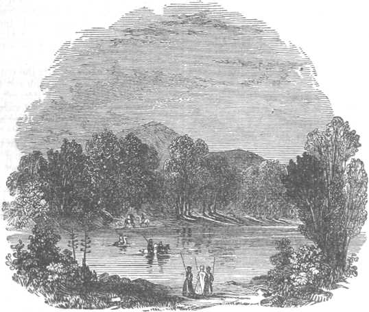
Fig. 286—Ford of the Jordan
The Lake Merom or Samochonitis, now called Huleh, the first of these, serves as a kind of reservoir to collect the waters which form the Jordan, and again to send them forth in a single stream. In the spring, when the waters are highest, the lake is seven miles long and three and a half broad; but in summer it becomes a mere marsh. In some parts it is sown with rice, and its reeds and rushes afford shelter to wild hogs.
The Lake of Gennesareth, called also the Sea of Galilee, and the Lake of Tiberias. After quitting the lake Merom, the River Jordan proceeds for about thirteen miles southward, and then enters the great Lake of Gennesareth. This lake lies very deep, among fruitful hills and mountains, from which, in the rainy season, many rivulets descend; its shape will be seen from the map. Its extent has been greatly over-rated: Professor Robinson considers that its length, in a straight line, does not exceed eleven or twelve geographical miles, and that its breadth is from five to six miles. From numerous indications, it is judged that the bed of this lake was formed by some ancient volcanic eruption, which history has not recorded. Its waters are very clear and sweet, and contain various kinds of excellent fish in great abundance. It will be remembered that several of the apostles were fishermen of this lake, and that it was also the scene of several transactions in the life of Christ. The borders of the lake were in the time of Christ well peopled, being covered with numerous towns and villages; but now they are almost desolate, and the fish and water-fowl are but little disturbed.
The Dead Sea, called also the Salt Sea, the Sea of Sodom, and the Asphaltic Lake (Lacus Asphaltites), is from its size the most important, and from its history and qualities the most remarkable, of all the lakes of Palestine. It is now thought probable that before the destruction of the cities of the plain, a lake existed, which, as now, received the River Jordan, but that an encroachment of the waters, southward, took place when these cities were destroyed, overwhelming a beautiful and well watered plain which lay on the southern border of the lake, and on which Sodom, Gomorrah, Admah, Zeboim, and Zoar were situated.
The Dead Sea is about thirty-nine or forty geographical miles long from north to south, and nine or ten miles wide from east to west; and it lies embedded very deep between lofty cliffs on the western side, which are about 1500 feet high, and mountains on the eastern shore, the highest ridges of which are reckoned to be from 2000 to 2500 feet above the water. The water of the lake is much saltier than that of the sea. From the quantity of salt which the water holds in solution it is thick and heavy, and no fish can live, or marine plants grow in it. Lying in its deep cauldron, surrounded by lofty cliffs of naked limestone rock, exposed for seven or eight months in the year to the unclouded beams of a burning sun, nothing but sterility and solitude can be looked for upon its shores; and nothing else is actually found, except in those parts where there are fountains or streams of fresh water; in all which places there is a fertile soil and abundant vegetation. Birds also abound, and they are observed to fly over and across the sea without being, as old stories tell, injured or killed by its exhalations.
On the borders of this lake is found much sulfur, in pieces as large as walnuts, and even larger. There is also a black shining stone, which will partly burn in the fire, and which then emits a bituminous smell: this is the ’stink-stone’ of Burckhardt. At Jerusalem it is made into rosaries and toys, of which great quantities are sold to the pilgrims who visit the sacred places. Another remarkable production found here, from which, indeed, the lake takes one of its names, is asphaltum, or bitumen. Josephus says, that ’the sea in many places sends up black masses of asphaltum, which float upon the surface, having the size and shape of headless oxen.’ From recent information it appears that large masses are rarely found, and then generally after earthquakes. The substance is doubtless produced from the bottom of the sea, in which it coagulates, and rises to the surface; or possibly the coagulation may have been ancient, and the substance adheres to the bottom until detached by earthquakes and other convulsions, when its buoyancy brings it to the surface. We know that ’the vale of Siddim’ (Gen 14:10) was anciently ’full of slime-pits’ or sources of bitumen; and these, now under the water, probably supply the asphaltum which is found on such occasions.
Climate and Seasons of Palestine
The variations of sunshine and rain which, with us, extend throughout the year, are in Palestine confined chiefly to the latter part of autumn and the winter. During all the rest of the year the sky is almost uninterruptedly cloudless, and rain very rarely falls.
The autumnal rains usually commence at the latter end of October, or beginning of November, not suddenly, but by degrees; which gives opportunity to the husbandman to sow his wheat and barley. During the months of November and December the rains continue to fall heavily; afterwards they return at longer intervals, and are not so heavy; but at no period during the winter do they entirely cease to occur. Rain continues to fall more or less during the month of March, but is afterwards very rare. Morning mists occur as late as May, but rain almost never. Rain in the time of harvest was as incomprehensible to an ancient Jew as snow in summer (Pro 26:1; 1Sa 12:17; Amo 4:7). The ’early’ and the ’latter’ rains, for which the Jewish husbandmen awaited with longing (Pro 16:15; Jas 5:7), seem to have been the first showers of autumn, which revived the parched and thirsty soil, and prepared it for the seed; and the later showers of spring, which continued to refresh and forward the ripening crops and the vernal products of the fields.
The cold of winter is not severe, and the ground is never frozen. Snow falls more or less, but even in the higher lands it does not lie long on the ground. Thunder and lightning are frequent in the winter.
In the plains and valleys the heat of summer is oppressive, but not in the more elevated tracts, as at Jerusalem, except when the south wind (Sirocco) blows (Luk 12:55). In such high grounds the nights are cool, often with heavy dew. The total absence of rain in summer soon destroys the verdure of the fields, and gives to the general landscape, even in the high country, an aspect of drought and barrenness. No green thing remains but the foliage of the scattered fruit-trees, and occasional vineyards and fields of millet. In autumn the whole land becomes dry and parched; the cisterns are nearly empty, and all nature, animate and inanimate, looks forward with longing for the return of the rainy season.
In the hill-country the season of harvest is later than in the plains of the Jordan and of the sea-coast. The barley harvest is about a fortnight earlier than that of wheat. In the plain of the Jordan the wheat-harvest is early in May; in the plains of the Coast and of Esdraelon it is towards the latter end of that month; and in the hills, not until June. The general vintage is in September, but the first grapes ripen in July, and from that time the towns are well supplied with this fruit.
The climate of Palestine has always been considered healthy, and the inhabitants have for the most part lived to a good old age (Tacit. Hist. v. 6). Jerusalem, in particular, from its great elevation, clear sky and invigorating atmosphere, should be a healthy place, and so it is generally esteemed; but the plague frequently appears among its ill-fed and uncleanly population; and bilious fevers, the result of great and sudden vicissitudes of temperature, are more common than might be expected in such a situation.
Inhabitants of Palestine
Under this head we present the reader with the following observations of Dr. Olin (Travels, ii. 438-439)—’The inhabitants of Palestine are Arabs; that is, they speak the Arabic, though, with slight exceptions, they are probably all descendants of the old inhabitants of Syria. They are a fine, spirited race of men, and gave Mohammed Ali much trouble in subduing them, and still more in retaining them in subjection. They are said to be industrious for Orientals, and to have the right elements for becoming, under better auspices, a civilized intellectual nation….The mercantile class is said to be little respected, and generally to lack integrity. Veracity is held very lightly by all classes. The people are commonly temperate and frugal, which may be denominated Oriental virtues. Their situation, with regard to the physical means of comfort and subsistence, is, in many respects, favorable, and under a tolerable government would be almost unequaled. As it is, the Syrian peasant and his family fare much better than the laboring classes of Europe. The people almost always appear well clothed. Their houses, too, though often of a slight construction and mean appearance, must be pronounced commodious when compared with the dark, crowded apartments usually occupied by the corresponding classes in Europe. Agricultural wages vary a good deal in different parts of the country, but I had reason to conclude that the average was not less than three or four piasters per day.’ With all these advantages population is on the decline, arising from polygamy, military conscription, unequal and oppressive taxation, forced labor, general insecurity of property, the discouragement of industry, and the plague.
Natural History of Palestine
As all the objects of natural history, mentioned in Scripture, are in the present work examined under the proper heads with unexampled care and completeness, by writers eminent in their several departments, it is unnecessary in this place to go over the ground which has been so advantageously preoccupied. It may suffice to mention the following facts in respect to the actual natural history of the country.—The olive certainly was, and still continues to be, the chief of all the trees of Palestine, which seems to be its natural home. Excellent oil is still obtained from the fruit. But although the pre-eminence among the trees of Palestine must be assigned to the olive, fig-trees also occur in great numbers, and the plantations sometimes cover large tracts which the eye can scarcely embrace. The fruit has a peculiarly pleasant flavor, and an aromatic sweetness, but is generally smaller than that of Smyrna. The vine, which is now only found in some districts of Palestine, is not surpassed by any on earth for the strength of its juice, and—at least in the southern mountains—for the size and abundance of the grapes.
The first tree whose blossoms appear prior to the period of the latter rains, and open in the very deep valleys before the cold days of February set in, is the Luz or almond-tree. In March, the fruit-trees are in blossom, among which are the apricot, the apple, and the pear; in April, the purple of the pomegranate flowers combines with the white of the myrtle blossoms; and at the same period the roses of the country, and the variegated ladanes (Cistus); the zukkim-tree (Elæagnus angustifolius), the storax-tree, whose flowers resemble those of the German jasmine (Philadelphus coronarius), emit their fragrant odors. The palm-tree is not now seen in the interior of the country; but it thrives well in the low lands near the coast. The tall cypress only exists in Palestine, as cultivated by man, in gardens, and in cemeteries, and other open places of towns. But as the spontaneous growth of the country, we find upon the heights and swelling hills the azarole (Cratægus azarolus), the walnut-tree, the strawberry-tree, the laurel-tree, the laurestinus, species of the pistachio and terebinth trees, of evergreen oaks, and of the rhamnus of the size of trees and shrubs, the cedrine juniper-tree, and some sorts of thymelæus; while on the formerly wooded heights various kinds of pine-trees, large and small, still maintain their ground. The sycamore, the carob trees, and the opuntia fig-trees, are only found as objects of cultivation in or near towns; and orchards of orange, and lemon trees occur chiefly in the neighborhood of Nabulus (Shechem).
The various kinds of corn grow spontaneously in great plenty in many districts, chiefly in the plains of Jezreel and the heights of Galilee, being the wild progeny of formerly cultivated fields, and bearing testimony by their presence to the fitness of the soil for the production of grain. In addition to wheat and barley, among this wild growth, the common rye was often seen. The present course of agriculture, which is but carelessly practiced, comprises nearly the same kinds of grain which are grown in Egypt. Fields are seen covered with the dhurah, or Holchus sorghum. Maize, spelt, and barley thrive everywhere; and rice is produced on the Upper Jordan and the marshy borders of the Lake Merom. Upon the Jordan, near Jacob’s bridge, may be seen fine tall specimens of the papyrus reed. Of pulse the inhabitants grow the chick pea, the blue chickling vetch, the Egyptian bean, the kidney bean, the gilban (Lathyrus sativus), together with the lentil, and the gray or field pea. Of esculent vegetables, the produce of the various species of hibiscus are much liked and cultivated. In some places the Christian inhabitants or Franks are endeavoring to introduce the potato. In the garden of the monasteries the artichoke is very common: in most districts, as about Nabulus (Shechem), the watermelon and cucumber are very common. Hemp is more generally grown in Palestine than flax; and in favorable localities cotton is cultivated, and also madder for dyeing.
Herds of black cattle are now but rarely seen in Palestine. The ox in the neighborhood of Jerusalem is small and unsightly, and beef or veal is but rarely eaten. But in the northern parts of the country the ox thrives better and is more frequently seen. The buffalo thrives upon the coast, and is there equal in size and strength to the buffalo of Egypt. Sheep and goats are still seen in great numbers in all parts of the country: their flesh and milk serve for daily food, and their wool and hair for clothing. The common sort of sheep in Palestine manifest the tendency to form a fat and large tail. The long-eared Syrian goat is furnished with hair of considerable fineness, but seemingly not so fine as that of the same species of goat in Asia Minor. Of animals of the deer kind, Schubert saw only the female of the fallow-deer; but several species of antelopes are met with in the country.
Camels are not reared to any extent worth mentioning. Palestine cannot boast of its native breed of horses, although fine animals of beautiful shape, and apparently of high Arabian race, are not infrequently seen. The ass of the country scarcely takes higher relative rank than the horse; asses and mules are still, however, much used for riding, as they afford a means of locomotion well suited to the difficult mountain paths of the country. Boars are very often observed upon Mount Tabor and the Lesser Hermon, as well as on the woody slopes of Mount Carmel. Among indigenous animals of the genus felis, we may name the common panther, which is found among the mountains of central Palestine; and in the genus canis there is the small Abul Hhosseyn, or Canis famelicus, and a kind of large fox (Canis Syriacus). In addition to these is the jackal, which is very injurious to the flocks. The hyena is found chiefly in the valley of the Jordan, and in the mountains around the lake of Tiberias, but is also occasionally seen in other districts of Palestine. Bears are said to be found in the Anti-Libanus, not far from Damascus. A hedgehog, procured near Bethlehem, was found to resemble the common European animal, and not to be the long-eared Egyptian species. The hare is the same as the Arabian. The porcupine is frequently found in the clefts of the rocks.
Among the larger birds of prey the common vulture and the kite are oftenest seen. The native wild dove differs not perceptibly from our own species, which is also the case with the shrikes, crows, rollers, and other species found in Palestine.
Tortoises are not uncommon. Serpents are rare, and none of those which have been observed are poisonous. The Janthina fragilis, which yields the common purple dye, has been noticed near the coast. Among the insects the bee is the most conspicuous. Mosquitoes are somewhat troublesome. Beetles are abundant, and of various species.
Denotes, in the Old Testament, the country of the Philistines, which was that part of the land of promise extending along the Mediterranean Sea on the varying western border of Simeon, Judah, and Dan, Exo 15:14 Isa 14:29,31 Joe 3:4 . Palestine, taken in later usage in a more general sense, signifies the whole country of Canaan, as well beyond as on this side of the Jordan; though frequently it is restricted to the country on this side that river; so that in later times the words Judea and Palestine were synonymous. We find also the name of Syria-Palestina given to the land of promise, and even sometimes this province is comprehended in Coele-Syria, or the Lower Syria. Herodotus is the most ancient writer known who speaks of SyriaPalestina. He places it between Phoenicia and Egypt. See CANAAN.\par
Pal’estine. (land of strangers). These two forms, [Palesti’na and Pal’estine], occur in the Authorized Version, but four times in all, always in poetical passages; the first in Exo 15:14 and Isa 14:29, the second in Joe 3:4. In each case, the Hebrew is Pelesheth, a word found, besides the above, only in Psa 60:8; Psa_ 83:7; Psa 87:4 and Psa 108:9. In all of which, our translators have rendered as "Philistia" or "Philistines." Palestine, in the Authorized Version, really means nothing, but Philistia. The original Hebrew word, Pelesheth, to the Hebrews signified merely the long and broad strip of maritime plain inhabited by their encroaching neighbors; nor does it appear that, at first, it signified more to the Greeks.
As lying next the sea, and as being also the high road from Egypt to Phoenicia and the richer regions, take note of it, but the Philistine plain became sooner known to the western world than the country farther inland, and was called by them, Syria Palestina (Philistine Syria). From thence, it was gradually extended to the country farther inland, till in the Roman and later Greek authors, both heathen sad Christian, it became the usual appellation for the whole country of the Jews, both west and east of Jordan. The word is now so commonly employed, in our more familiar language, to destinate the whole country of Israel that, although biblically a misnomer, it has been chosen here as the most convenient heading under which to give a general description of The Holy Land, embracing those points which have not been treated under the separate headings of cities or tribes.
This description will most conveniently divide itself Into three sections: -- I. The Names applied to the country of Israel in the Bible and elsewhere. II. The Land; its situation, aspect, climb, physical characteristics in connection with its history, its structure, botany and natural history. III. The History of the country is so fully given, under its various headings throughout the work, that it is unnecessary to recapitulate it here.
I. The Names. -- Palestine, then, is designated in the Bible by more than one name. During the patriarchal period, the conquest and the age of the Judges, and also where those early periods are referred to in the later literature (as in) Psa 105:11, it is spoken of as "Canaan", or more frequently, "the land of Canaan", meaning thereby, the country west of the Jordan, as opposed to "the land of Gilead", on the east.
During the monarchy, the name usually, though not frequently, employed is "the land of Israel". 1Sa 13:19.
Between the captivity and the time of our Lord, the name "Judea" had extended itself, from the southern portion, to the whole of the country, and even that beyond the Jordan. Mat 19:1; Mar 10:1.
The Roman division of the country hardly coincided with the biblical one, and it does not appear that the Romans had any distinct name for that which we understand by Palestine.
Soon after the Christian era, we find the name "Palestina" in possession of the country.
The name most frequently used throughout the middle ages, and down to our own time, is Terra Sancta -- The Holy Land.
II. The Land. -- The Holy Land is not, in size or physical characteristics, proportioned to its moral and historical position as the theatre of the most momentous events in the world’s history. It is but a strip of country about the size of Wales, less than 140 miles in length and barely 40 miles in average breadth, on the very frontier of the East, hemmed in between the Mediterranean Sea, on the one hand, and the enormous trench of the Jordan valley, on the other, by which it is effectually cut off from the mainland of Asia behind it. On the north, it is shut in by the high ranges of Lebanon and Anti-Lebanon, and by the chasm of the Litany. On the south, it is no less enclosed by the arid and inhospitable deserts of the upper pert of the peninsula of Sinai.
Its position. -- Its position on the map of the world -- as the world was when the Holy Land first made its appearance in history -- is a remarkable one.
(a) It was on the very outpost -- and the extremist western edge of the East. On the shore of the Mediterranean it stands, as if it had advanced as far as possible toward the west, separated therefrom by that which, when the time arrived, proved to be no barrier, but the readiest medium of communication: the wide waters of the "great sea." Thus, it was open to all the gradual influences of the rising communities of the West, while it was saved from the retrogression and decrepitude, which have ultimately been the doom of all purely eastern states whose connections were limited to the East only.
(b) There was, however, one channel, and but one, by which it could reach and be reached by the great Oriental empires. The rivals road by which the two great rivals of the ancient world could approach one another -- by which alone, Egypt could get to Assyria and Assyria to lay along the broad flat strip of coast which formed the maritime portion of the Holy Land, and thence, by the plain of the Lebanon to the Euphrates.
(c) After this, the Holy Land became, (like the Netherlands in Europe), the convenient arena on which, in successive ages, the hostile powers who contended for the empire of the East fought their battles.
Physical features. -- Palestine is essentially a mountainous country. Not that if contains independent mountain chains, as in Greece, for example, but that every part of the highland is in greater or less undulation. But it is not only a mountainous country. The mass of hills which occupies the centre of the country is bordered or framed on both sides, east and west, by a broad belt of Shefelah, or lowland, sunk deep below its own level. The slopes or cliffs, which form, as if it were, the retaining walls of this depression, are furrowed and cleft by the torrent beds, which discharge the waters of the hills, and form the means of communication between the upper and lower level.
On the west, this Shefelah, or lowland, interposes between the mountains and the sea, and is the plain of Philistia and of Sharon. On the east, it is the broad bottom of the Jordan valley, deep down in which rushed the one river of Palestine to its grave in, the Dead Sea. Such is the first general impression of the physiognomy of the land. It is a physiognomy compounded of the three main features already named -- the plains, the highland hills, and the torrent beds features, which are marked in the words of its earliest describers, Num 13:29; Jos 11:16; Jos 12:8, and which must be comprehended by every one who wishes to understand the countrym and the intimate connection existing between its structure and its history.
About halfway up the coast, the maritime plain is suddenly interrupted by a long ridge thrown out from the central mass, rising considerably to shove up the general level, and terminating in a bold promontory on the very edge of the Mediterranean. This ridge is Mount Carmel. On its upper side, the plain, as if to compensate for its temporary displacement, invades the centre of the country, and forms an undulating hollow right across it from the Mediterranean to the Jordan valley.
This central Shefelah, or lowland, which divides, with its broad depression, the mountains of Ephraim from the mountains of Galilee, is the plain of Esdraelon or Jezreel: the great battle-field of Palestine. North of Carmel, the Shefelah, or lowland resumes its position by the seaside till it is again interrupted, and finally put an end to, by the northern mountains, which push their way out of the sea, ending in the white promontory of the Ras Nakhura.
Above this is the ancient Phoenicia. The country, thus roughly portrayed, is, to all intents and purposes, the whole land of israel. The northern portion is Galilee; the centre is Samaria; and the south is Judea. This is the land of Canaan, which was bestowed on Abraham, -- the covenanted home of his descendants.
The highland district, surrounded and intersected by its broad Shefelah, or lowland plains, preserves, from north to south, a remarkably even and horizontal profile. Its average height may betaken as 1600 to 1800 feet above the Mediterranean. It can hardly be denominated a plateau; yet, so evenly is the general level preserved and so thickly do the hills stand behind and between one another, that, when seen from the coast, or the western part of the maritime plain, it has quite the appearance of a wall. This general monotony of profile is however, relieved at intervals, by certain centers of elevation.
Between these elevated points runs the watershed of the country, sending off on either hand -- to the Jordan valley on the east, and the Mediterranean on the west -- the long, tortuous arms of ifs many torrent beds. The valleys, on the two sides of the watershed, differ considerably in character. Those on the east are extremely steep and rugged, while the western valleys are more gradual in their slope.
Fertility. -- When the highlands of the country are more closely examined, a considerable difference will be found to exist in the natural condition and appearance of their different portions. The south, as being nearer the arid desert and farther removed from the drainage of the mountains, is drier and less productive than the north. The tract below Hebron, which forms the link between the hills of Judah and the desert, was known to the ancient Hebrews by a term originally derived from its dryness -- Negeb. This was the south country.
As the traveller advances north of this tract, there is an improvement; but perhaps no country equally cultivated is more monotonous, bare or uninviting in its aspect than a great part of the highlands of Judah and Benjamin, during the larger portion of the year. The spring covers even those bald gray rocks with verdure and color, and fills the ravines with torrents of rushing water; but in summer and autumn, the look of the country from Hebron up to Bethel is very dreary and desolate. At Jerusalem, this reaches its climax.
To the west and northwest of the highlands, where the sea-breezes are felt, there is considerably more vegetation. Hitherto, we have spoken of the central and northern portions of Judea. Its eastern portion -- a tract some nine or ten miles in width by about thirty-five miles in length, which intervenes between the centre and the abrupt descent to the Dead Sea -- is far more wild and desolate, and that, not for a portion of the year only, but throughout it. This must have been always what it is now -- an uninhabited desert, because uninhabitable.
No descriptive sketch of this part of the country can be complete which does not allude to the caverns, characteristic of all limestone districts, but here, existing in astonishing numbers. Every hill and ravine is pierced with them, some very large and of curious formation -- perhaps partly natural, partly artificial -- others mere grottos. Many of them are connected with most important, and interesting events of the ancient history of the country. Especially is this true of the district now under consideration. Machpelah, Makkedah, Adullam En-gedi, names inseparably connected with the lives, adventures and deaths of Abraham, Joshua, David and other Old Testament worthies, are all within the small circle of the territory of Judea.
The bareness and dryness which prevail more or less in Judea are owing partly to the absence of wood, partly to its proximity to the desert, and partly to a scarcity of water, arising from its distance from the Lebanon. But to this discouraging aspect, there are some important exceptions. The valley of Urtas, south of Bethlehem, contains springs which, in abundance and excellence, rival even those of Nablus. The huge "Pools of Solomon" are enough to supply a district for many miles round them; and the cultivation, now going on in that neighborhood, shows what might be done with a soil which required only irrigation, and a moderate amount of labor, to evoke a boundless produce.
It is obvious that, in the ancient days of the nation, when Judah and Benjamin possessed the teeming population indicated in the Bible, the condition and aspect of the country must have been very different. Of this, there are, not wanting, sure evidences. There is no country in which the ruined towns bear so large a proportion to those still existing. Hardly a hill-top of the many within sight that is not covered with vestiges of some fortress or city. But, besides this, forests appear to have stood in many parts of Judea until the repeated invasions and sieges caused their fall; and all this vegetation must have reacted on the moisture of the climate, and, by preserving the water in many a ravine and natural reservoir where now it is rapidly dried by the fierce sun of the early summer, must have influenced, materially , the look and the resources of the country.
Advancing northward from Judea, the country, (Samaria), becomes gradually more open and pleasant. Plains of good soil occur between the hills, at first, small, but afterward, comparatively large. The hills assume here a more varied aspect than in the southern districts, springs are more abundant and more permanent until at last, when the district of Jebel Nablus is reached -- the ancient Mount Ephraim -- the traveller encounters an atmosphere and an amount of vegetation and water which are greatly superior to anything he has met with in Judea, and even sufficient to recall much of the scenery of the West.
Perhaps the springs are the only objects which in themselves, and apart from their associations, really strike an English traveller with astonishment and admiration. Such glorious fountains as those of Ain-jalud or the Ras el-Mukatta -- where a great body of the dearest water wells silently but swiftly out from deep blue recesses worn in the foot of a low cliff of limestone rock, and at once, forms a considerable stream -- are rarely to be met with out of irregular, rocky, mountainous countries, and being such unusual sights can hardly be looked on by the traveler, without surprise and emotion.
The valleys which lead down from the upper level in this district to the valley of the Jordan are less precipitous than in Judea. The eastern district of the Jebel Nablus contains some of the most fertile end valuable spots in the Holy Land. Hardly less rich is the extensive region which lies northwest of the city of Shechem (Nablus), between it and Carmel, in which the mountains gradually break down into the plain of Sharon.
But with all its richness and all its advance on the southern part of the country, there is a strange dearth of natural wood about this central district. It is this which makes the wooded sides of Carmel and the park-like scenery of the adjacent slopes and plains so remarkable. No sooner, however, is the plain of Eadraelon passed than a considerable improvement is perceptible. The low hills which spread down from the mountains of Galilee, and form the barrier between the plains of Akka and Esdraelon, are covered with timber, of moderate size, it is true, but of thick, vigorous growth, and pleasant to the eye. Eastward of these hills, rises the round mass of Tabor dark with its copses of oak, and set on, by contrast, with the bare slopes of Jebel ed-Duhy, (the so called "Little Hermon") and the white hills of Nazareth.
A few words must be said in general description of the Shefelah, or maritime lowland, which intervenes between the sea and the highlands. This region, only slightly elevated above the level of the Mediterranean, extends without interruption from el-Arish, south of Gaza, to Mount Carmel. It naturally divides itself into two portions, each of about half its length; the lower one, the wider, and the upper one, the narrower. The lower half is the plain of the Philistines-Philistia, or, as the Hebrews called it, the Shefelah, or Lowland. The upper half is the Sharon, or Saron, of the Old and New Testaments.
The Philistine plain is on an average 15 or 16 miles in width, from the coast to the beginning of the belt of hills, which forms the gradual approach to the high land of the mountains of Judah. The larger towns, as Gaza and Ashdod, which stand near the shore, are surrounded with huge groves of olive, and sycamore, as in the days King David. 1Ch 27:28.
The whole plain appears to consist of brown, loamy soil, light, but rich, and almost without a stone. It is now, as it was when the Philistines possessed it, one enormous cornfield; an ocean of wheat covers the wide expense between the hills and the sand dunes of the seashore, without interruption of any kind -- no break or hedge, hardly even a single olive tree. Its fertility is marvellous; for the prodigious crops which if raises are produced, and probably have been produced. Almost year by year. For the last forty centuries, without any of the appliances which we find necessary for success.
The plain of Sharon is much narrower than the plain of the Philistines-Philistia. It is about 10 miles wide from the sea to the foot of the mountains, which are, here, of a more abrupt character than those of Philistia, and without the intermediate hilly region there occurring.
The one ancient port of the Jews, the "beautiful", city of Joppa, occupied a position central between the Shefelah and Sharon. Roads led from these various cities to each other to Jerusalem, Neapolis and Sebaste in the interior, and to Ptolemais and Gaza on the north and south. The commerce of Damascus, and beyond Damascus, of Persia and India, passed this way to Egypt, Rome and the infant colonies of the West; and that traffic and the constant movement of troops backward and forward must have made this plain, at the time of Christ, one of the busiest and most populous regions of Syria.
The Jordan valley. -- The chacteristics already described are hardly peculiar to Palestine, but there is one feature, as yet only alluded to, in which she stands alone. This feature is the Jordan -- the one river of the country. The river is elsewhere described; see Jordan, but it and the valley through which it rushes down its extraordinary descent must be here briefly characterized. This valley begins with the river at its remotest springs of Hasbeiya, on the northwest side of Hermon, and accompanies it to the lower end of the Dead Sea, a length of about 150 miles. During the whole of this distance, its course is straight and its direction nearly due north and south.
The springs of Hasbeiya are 1700 feet above the level of the Mediterranean and the northern end of the Dead Sea is 1317 feet below it, so that, between these two points, the valley falls with more or less regularity, through a height of more than 3000 feet. But though the river disappears at this point, the valley still continues its descent below the waters of the Dead Sea till it reaches a further depth of 1308 feet. So that the bottom of this extraordinary crevasse is actually more than 2600 feet below the surface of the ocean.
In width, the valley varies. In its upper and shallower portion, as between Banias and the lake of Merom (Huleh), it is about five miles across. Between the lake of Merom and the Sea or Galilee, it contracts, and becomes more of an ordinary ravine or glen. It is in its third and lower portion that the valley assumes its more definite and regular character. During the greater part of this portion, it is about seven miles wide from the one wall to the other.
The eastern mountains preserve their straight line of direction, and their massive horizontal wall-like aspect, during almost the whole distance. The western mountains are more irregular in height, their slopes less vertical. North of Jericho, they recede in a kind of wide amphitheatre, and the valley becomes twelve miles broad -- a breadth which it, thenceforward, retains to the southern extremity of the Dead Sea.
Buried, as it is, between such lofty ranges, and shielded from every breeze, the climate of the Jordan valley is extremely hot and relaxing. Its enervating influence is shown by the inhabitants of Jericho. All the irrigation necessary for the cultivation, which formerly existed, is obtained front the torrents of the western mountains. For all purposes to which a river ordinarily applied the Jordan is useless. The Dead Sea, which is the final receptacle of the Jordan, is described elsewhere. See Sea, The Salt.
Climate. -- "Probably there is no country in the world of the same extent which has a greater variety of climate than Palestine. On Mount Hermon, at its northern border, there is perpetual snow. From this, we descend successively by the peaks of Bashan and upper Galilee, where the oak and pine flourish, to the hills of Judah and Samaria, where the vine and fig tree are at home, to the plains of the seaboard, where the palm and banana produce their fruit, down to the sultry shores of the Sea, on which we find tropical heat and tropical vegetation." -- McClintock and Strong.
As, in the time of our Saviour, Luk 12:64, the rains come chiefly from the south or southwest. They commence at the end of October or beginning of November, and continue, with greater or less constancy, till the end of February or March. It is not a heavy, continuous rain, so much as a succession of severe showers or storms, with intervening periods of fine, bright weather. Between April and November, there is, with the rarest exceptions, an uninterrupted succession of fine weather and skies without a cloud. Thus, the year divides itself into two, and only two, seasons -- as indeed we see it constantly divided in the Bible -- "winter and summer;" "cold and heat;" "seed-time and harvest."
Botany. -- The botany of Syria and Palestine differs but little from that of Asia Minor, which is one of the most rich and varied on the globe. Among trees, the oak is by far the most prevalent. The trees of the genus Pistacia rank next to the oak in abundance, and of these there are three species in Syria. There is also the carob or locust tree (Ceratonia siliqua), the pine, sycamore, poplar and walnut.
Of planted trees and large shrubs, the first in importance is the vine, which is most abundantly cultivated all over the country, and produces, as in the time of the Canaanites, enormous bunches of grapes. This is especially the case in the southern districts, those of Eshcol being still particularly famous. Next to the vine, or even in some respects, its superior in importance, ranks the olive, which nowhere grows in greater luxuriance and abundance than in Palestine, where the olive orchards form a prominent feature throughout the landscape, and have done so from time immemorial. The fig forms another most important crop in Syria and Palestine.
(Besides these are the almond, pomegranate, orange, pear, banana, quince and mulberry among fruit trees. Of vegetables, there are many varieties, such as the egg plant, pumpkin, asparagus, lettuce, melon and cucumber. Palestine is especially distinguished for its wild flowers, of which there are more than five hundred varieties. The geranium, pink, poppy, narcissus, honeysuckle, oleander, jessamine, tulip and iris are abundant. The various grains are also very largely cultivated. -- Editor).
Zoology. -- It will be sufficient, in this article, to give a general survey of the fauna of Palestine, as the reader will find more particular information in the several articles, which treat of the various animals, under their respective names. Jackals and foxes are common; the hyena and wolf are also occasionally observed; the lion is no longer a resident in Palestine or Syria. A species of squirrel of which the term orkidaun, "the leaper", has been noticed on the lower and middle parts of Lebanon. Two kinds of hare, rats and mice, which are said to abound, the jerboa, the porcupine, the short-tailed field-mouse, may be considered as the representatives of the Rodentia.
Of the Pachydermata, the wild boar, which is frequently met with on Taber and Little Hermon, appears to be the only living wild example. There does not appear to be at present any wild ox in Palestine. Of domestic animals, we need only mention the Arabian or one-humped camel, the ass, the mule and the horse, all of which are in general use. The buffalo (Bubalus buffalo) is common. The ox of the country is small and unsightly in the neighborhood of Jerusalem, but in the richer pastures, the cattle, though small, are not unsightly. The common sheep of Palestine is the broadtail, with its varieties. Goats are extremely common everywhere.
Palestine abounds in numerous kinds of birds. Vultures, eagles, falcons, kites, owls of different kinds represent the Raptorial order. In the south of Palestine especially, reptiles of various kinds abound. It has been remarked that, in its physical character, Palestine presents on a small scale, an epitome of the natural features of all regions, mountainous and desert, northern and tropical, maritime and inland, pastoral, arable and volcanic.
Antiquities. -- In the preceding descriptions, allusion has been made to many of the characteristic features of the Holy Land; but it is impossible to close this account, without mentioning a defect which is even more characteristic -- its lack of monuments and personal relics of the nation, which possessed it for so many centuries, and gave it its claim to our veneration and affection. When compared with other nations of equal antiquity -- Egypt, Greece, Assyria -- the contrast is truly remarkable.
In Egypt and Greece, and also in Assyria, as far as our knowledge at present extends, we find a series of buildings reaching down from the most remote and mysterious antiquity, a chain of which hardly a link is wanting, and which records the progress of the people in civilization, art and religion, as certainly as the buildings of the medieval architects do that of the various nations of modern Europe.
But in Palestine, it is not too much to say that, there does not exist a single edifice, or part of an edifice, of which we can be sure that it is of a date, anterior to the Christian era. And as with the buildings, so with other memorials.
With one exception, the museums of Europe do not possess a single piece of pottery or metal work, a single weapon or household utensil, an ornament or a piece of armor of Israelite make, which can give us the least conception of the manners or outward appliances of the nation before the date of the destruction of Jerusalem by Titus.
The coins form the single exception. M. Renan has named two circumstances, which must have had a great effect in suppressing art or architecture amongst the ancient Israelites, while their very existence proves that the people had no genius in that direction. These are
(1) the prohibition of sculptured representations of living creatures, and
(2) the command not to build a Temple anywhere, but at Jerusalem.
"The holy land," Zec 2:12; Zec 7:14, "land of desire"; Dan 8:9. "the pleasant land"; Dan 11:16; Dan 11:41, "the glorious (or goodly) land"; Eze 20:6; Eze 20:15, "a land that I had espied for them flowing with milk and honey, which is the glory of all lands." God’s choice of it as peculiarly His own was its special glory (Psa 132:13; Psa 48:2; Jer 3:19 margin "a good land, a land of brooks of water (wadies often now dry, but a few perennial), of fountains and depths that spring out of valleys and hills (the deep blue pools, the sources of streams), a land of wheat, barley, vines, figtrees, pomegranates, oil olive, honey (
"The land of Israel" in the larger sense (1Sa 13:19); in the narrower sense of the northern kingdom it occurs 2Ch 30:25. After the return from Babylon "Judaea" was applied to the whole country S. and N., and E. beyond Jordan (Mat 19:1). "The land of promise" (Heb 11:9). "Judaea" in the Roman sense was part of the province "Syria," which comprised the seaboard from the bay of Issus to Egypt, and meant the country from Idumea on the S. to the territories of the free cities on the N. and W., Scythopolis, Sebaste, Joppa, Azotus, etc. The land E. of Jordan between it and the desert, except the territory of the free cities Poilu, Gadara, Philadelphia, was "Perea." From Dan (Banias) in the far N. to Beersheba on the S. is 139 English miles, two degrees or 120 geographical miles. The breadth at Gaza from the Mediterranean to the Dead Sea is 48 geographical miles; at the Litany, from the coast to Jordan is 20 miles; the average is 34 geographical or 40 English miles. About the size of Wales. The length of country under dominion in Solomon’s days was probably 170 miles, the breadth 90, the area 12,000 or 13,000 square miles.
The population, anciently from three to six millions, is now under one million. The Jordan valley with its deep depression separates it from the Moab and Gilead highlands. Lebanon, Antilebanon, and the Litany ravine at their feet form the northern bound. On the S. the dry desert of Paran and "the river of Egypt" bound it. On the western verge of Asia, and severed from the main body of Asia by the desert between Palestine and the regions of Mesopotamia and Arabia, it looks on the other side to the Mediterranean and western world, which it was destined by Providence so powerfully to affect; oriental and reflective, yet free from the stagnant and retrogressive tendencies of Asia, it bore the precious spiritual treasure of which it was the repository to the energetic and progressive W. It consists mainly of undulating highlands, bordered E. and W. by a broad belt of deep sunk lowland.
The three main features, plains, hills, and torrent beds, are specified (Num 13:29; Jos 11:16; Jos 12:8). Mount Carmel, rising to the height of above 1,700 ft., crosses the maritime plain half way up the coast with a long ridge from the central chain, and juts out into the Mediterranean as a bold headland. The plain of Jezreel or Esdraelon on its northern side, separating the Ephraim mountains from those of Galilee, and stretching across from the Mediterranean to the Jordan valley, was the great battlefield of Palestine. Galilee is the northern portion, Samaria the middle, Judaea the southern. The long purple wall of Gilead and Moab’s hills on the eastern side is everywhere to be seen. The bright light and transparent air enable one from the top of Tabor, Gerizim or Bethel at once to see Moab on the E. and the Mediterranean on the W. On a line E. of the axis of the country and running N. and S. lie certain elevations: Hebron 3,029 ft. above the sea; Jerusalem, 2,610; Olivet, 2,724; Neby Samwil on the N., 2,650; Bethel, 2,400; Ebal and Gerizim, 2,700; Little Hermon and Tabor, N. of the Esdraelon plain, 1,900.
The watershed sends off the drainage of the country in streams running W. to the Mediterranean and E. to the Jordan, except at the Esdraelon plain and the far N. where the drainage is to the Litany. Had the Jews been military in character, they would easily have prevented their conquerors from advancing up the precipitous defiles from the E., the only entrances to the central highlands of Judah, Benjamin, and Ephraim, from the Jordan valley; as Engedi (2Ch 20:1-2; 2Ch 20:16) and Adummim, the route between Jericho and Jerusalem by which Pompey advanced when he took the capital. The slope from the western valleys is more gradual, as the level of the plain is higher, and the distance up the hills longer, than from the eastern Jordan depression; still the passes would be formidable for any army with baggage to pass. From Jaffa up to Jerusalem there are two roads: the one to the right by Ramleh and the wady Aly; the other the historic one by Lydda and the Bethorons, or the wady Suleiman, and Gibeon.
By this Joshua drove the Canaanites to the plains; the Philistines went up to Michmash, and fled back past Ajalon. The rival empires, Egypt and Babylon-Assyria, could march against one another only along the maritime western plain of Palestine and the Lebanon plain leading toward and from the Euphrates. Thus Rameses II marched against the Chitti or Hittites in northern Syria, and Pharaoh Necho fought at Mefiddo in the Esdraelon plain, the battlefield of Palestine; they did not meddle with the central highlands, "The S. country" being near the desert, destitute of trees, and away from the mountain streams, is drier than the N., where springs abound.
The verdure and blaze of scarlet flowers which cover the highlands of Judah and Benjamin in spring, while streams pour down the ravines, give place to dreary barrenness in the summit. Rounded low hills, with coarse gray stone, clumps of oak bushes, and the remains of ancient terraces running round them, meet one on each side, or else the terraces are reconstructed and bear olives and figs, and vineyards are surrounded by rough walls with watchtowers. Large oak roots are all that attest the former existence of trees along the road between Bethlehem and Hebron. Corn or
The tract, nine miles wide and 35 long, between the center and the sudden descent to the Dead Sea, is desolate at all seasons, a series of hills without vegetation, water, and almost life, with no ruins save Masada and one or two watchtowers. (On the caves, see CAVES.) No provision is made in the S. for preserving the water of the heavy winter and spring rains, as in Malta and Bermuda. The valley of Urtas, S. of Bethlehem, abounding in springs, and the pools of Solomon, are exceptions to the general dryness of the S. The ruins on every hill, the remains of ancient terraces which kept the soil up from being washed into the valleys, and the forests that once were in many parts of Judea until invasions and bad government cleared them away, and which preserved the moistness in the wadies, confirm the truth of the Bible account of the large population once maintained in Judah and Benjamin. The springs and vegetation as one advances N. toward Mount Ephraim especially strike the eye.
Such springs as Ain Jalud or Rasel Mukatta, welling forth as a considerable stream from the limestone, or Tel el Kady forming a deep clear pool issuing from a woody mound, or Banias where a river issues roaring from its cave, or Jenin bubbling from the level ground, are sights striking by their rarity. Mount Ephraim (jebel Nablus) contains some of the most productive land in Palestine. Fine streams, with oleanders and other flowering trees on their banks, run through the valleys which are often well cultivated. N.W. of Nablus is the large, rich, grain abounding, and partly wooded district toward Carmel, which reaches to where the mountains slope down to Sharon plain under Mount Carmel. Extensive woods there are none, and the olives which are found everywhere but little improve the landscape. This absence of woods elsewhere makes their presence on Carmel’s sides, and parklike slopes, the more striking. N. of Esdraelon the Galilee hills abound in timber, the land round Tabor is clad in dark oak, forming a contrast to jebel ed Duhy (Little Hermon) and Nazareth’s white hills.
Oaks, terebinths, maples, arbutus, sumach, etc., cover the ravines and slopes of the numerous swelling hills, and supply the timber carried to Tyre for export as fuel to the seacoast towns. The hills throughout Palestine are crowned with remains of fenced cities, scarcely a town existed in the valleys. Inaccessibility was their object, for security; also the treacherous nature of the alluvial sand made the lower position unsafe in times of torrent floods from the hills, whereas the rock afforded a firm foundation (Mat 7:24-27). Unlike ordinary conquests, the Israelite conquerors took the hills, but the conquered Canaanites kept the plains where their chariots could maneuver (Jdg 1:19-35). Appropriately a highland coloring tinges their literature (Psa 72:3; Psa 72:16; Isa 2:2; Eze 36:1,; 1Ki 20:28). The hills were the sites also of the forbidden "high places." The panoramic views from many hills, trodden by patriarchs, prophets, and heroes, as Olivet, Bethel, Gerizim, Carmel, Tabor, etc., are remarkable for their wide extent, comprising so many places of historic interest at once, owing to the clearness of the air.
The seacoast lowland between the hills and sea stretches from
Its undulations are crossed by perennial streams from the central hills, which instead of spreading into marshes, as now, might be utilized for irrigation. The ancient irrigatory system, with passes cut through the solid wall of cliff near the sea for drainage, is choked up. The rich soil varies from red to black, and on the borders of the marshes and streams are rank meadows where herds still feed, as in David’s days (1Ch 27:29). The white sand is encroaching on the coast. In the N. between Jaffa and Caesarea sand dunes are reported to exist, three miles wide, 300 ft. high. The Jews, though this region with its towns was assigned to them (Jos 15:45-47; Jos 13:3-6; Jos 16:3 Gezer, Jos 17:11 Dor), never permanently occupied it. The Philistines kept their five cities independent of, and sometimes supreme over, Israel (1 Samuel 5; 1Sa 21:10; 1Sa 27:2; 1Ki 2:39; 2Ki 8:2-3).
The Canaanites held Dor (Jdg 1:27) and Gezer until Pharaoh took it and gave it to his daughter, Solomon’s wife (1Ki 9:16). Lod (Lydda) and Ono were in Benjamin’s possession toward the end of the monarchy and after the return from Babylon (Neh 11:34; 2Ch 28:18). Gaza and Askelon had regular ports (majumas, Kenrick, Phoen. 27-29). Ashdod was strong enough to withstand the whole Egyptian force for 29 years. Under Rome Caesarea, (now a ruin washed by the sea) and Antipatris in this region were leading cities of the province. Joppa between Philistia and Sharon. is still the seaport for travelers from the W. to Jerusalem, and was Israel’s only harbor. They had no word for harbor, so unversed in commerce were they; yet their sacred poets show their appreciation of the phenomena of the sea (Psa 104:25-26; Psa 107:23-30). Bedouin marauders and Turkish misrule have closed the old coast route between N. and S., and left the fertile and to be comparatively uncultivated. The Jordan valley is the special feature of Palestine.
Syria is divided, from Antioch in the N. to Akaba on the eastern extremity of the Red Sea, by a deep valley parallel to the Mediterranean and separating the central highlands from the eastern ones. The range of Lebanon and Hermon crosses this valley between its northern portion, the valley of the Orontes. and its main portion the valley of Jordan (the
The climate of the Jordan valley is tropical and enervating, and the men of Jericho a feeble race. "The region round about Jordan" was used of the vicinity of Jericho (Mat 3:5). The Jordan is perennial, but most of the so-called "rivers" are mere "winter torrents" (
Hebron; "going down" to Jericho, Gaza, Egypt. "The mountain of Judah," "of Ephraim," "of Naphtali," designate the three great groups of highlands. In these the characteristic names occur, Gibeah, Geba, Gibeon (hill), Ramah, Ramathaim ("brow"), Mizpeh, Zonhim (watchtower, watchers). The lower hills and southern part of the seacoast plain is the "
ANTIQUITIES. In contrast to Egypt, Assyria, and Greece, Palestine does not contain an edifice older than the Roman occupation. There are but few remains left illustrating Israelite art. The coins, rude and insignificant, the oldest, being possibly of the Maccabean era, are the solitary exception. The enclosure round Abraham’s tomb at Hebron we know not the date of Solomon’s work still remains in some places. Wilson’s arch is probably Solomonic, and the part of the sanctuary wall on E. side.
GEOLOGY. Palestine is a much disturbed mountainous tract of limestone, of the secondary or jurassic and cretaceous period. It is an offshoot from Lebanon, much raised above the sea, with partial interruptions from tertiary and basaltic deposits. The crevasse of the Jordan is possibly volcanic in origin, an upheaval tilting the limestone so as to leave a vast split in the strata, but stopping without intruding volcanic rocks into the fissure. The basins of the sea of Galilee and the Dead Sea resemble craters. Others attribute the chasm to the ocean’s gradual action in immense periods. The hills range mainly N. and S. The limestone consists of two groups of strata. The upper is a solid stone varying from white to reddish brown, with few fossils, and abounding in caverns; the strata sometimes level for terraces, oftener violently disarranged, and twisted into various forms, as on the road from Jerusalem to Jericho.
This limestone is often topped with flint-abounding chalk, as on the western side of the Dead Sea, where it has many salt and sulfurous springs. Dolomite or magnesian limestone, a send-crystalline rock, white or brown with glistening surface, blends with the mass of limestone, near Jerusalem. The lower limestone group has two series of beds: the upper darkish, cavernous, and ferruginous; the lower dark gray, solid, abounding in the fossil cidaris, an extinct echinus, the spines of which are the "olives" of the convents. This is the substratum of the whole country E. and W. of Jordan. The ravine from Olivet to Jericho affords an opportunity of examining the strata through which it cuts. After the limestone had assumed its present outline, lava burst, from beneath and overflowed the stratified beds, as basalt or trap, long before historic times. These volcanic rocks are found in the cis-Jordanic country, only N. of the Samaria mountains, e.g. S.W. of Esdraelon plain and N. of Tabor. The two centers of eruption were:
(1) The older about Kuru Hattin, the traditional mount of beatitudes, from whence the lava flowed forming the cliffs at the back of Tiberius; the disintegration of the basalt formed the fertile black soil of the plain of Gennesaret.
(2) The more recent, near Safed, where three craters have become the lakes el Jish, Taiteba, and Delata.
The earthquake in Uzziah’s time (Zec 14:5), which injured the temple and brought down a mass of rock from Olivet (Josephus, Ant. 9:10, section 4), shows that volcanic action has continued in historic times. From the 13th to the 17th centuries A.D. earthquakes were unknown in Syria and Judaea, but the Archipelago and southern Italy suffered greatly. Since than their activity has been resumed, destroying Aleppo in 1616 and 1822. Antioch in 1737, and Tiberius and Safed in 1837. See Amo 4:11; compare Mat 27:51; Psa 46:1-2. The hot salt and fetid springs at Tiberias,
Here and E. of the upper Jordan the most remarkable igneous rocks are found; the limestone lies underneath. The Lejah, anciently Argob or Trachonitis, has scarcely anything exactly like it on the earth.
It chokes the streams in places, and forms marshes which might be utilized for promoting fertility. The plain of Gennesaret is richer land, owing to the streams flowing all the year round, and to the decay of volcanic rocks on the surrounding heights. Esdraelon plain is watered by the finest springs of Palestine, and has a volcanic soil. Asphalt or bitumen is only met with in the valley of the Jordan, and in fragments floating on the water or at the shore of the Dead Sea. Bituminous limestone probably exists in thick strata near neby Musa; thence bitumen escapes from its lower beds into the Dead Sea, and there accumulates till, becoming accidentally detached, it rises to the surface. Sulphur is found on the W., S., and S.E. shore of the Dead Sea, a sulfurous crust spreading over the beach. Niter is rare. Rock salt abounds. The Khasm Usdum, a mound at the S. of the Dead Sea, is five miles and a half long by two and a half broad, and several hundred feet high; the lower part rock salt, the upper Sulphate of lime and salt with alumina.
BOTANY. Palestine is the southern and eastern limit of the Asia Minor flora, one of the richest in the earth, and contains many trees and herbs as the pine, oak, elder, bramble, dogrose, hawthorn, which do not grow further S. and E. owing to the dryness and heat of the regions beyond hilly Judaea. Persian forms appear on the eastern frontier, Arabian and Egyptian on the southern. Arabian and Indian tropical plants of about 100 different kinds are the remarkable anomaly in the torrid depression of the Jordan and Dead Sea. The general characteristics, owing to the geographical position and mountains of Asia Minor and Syria, are Mediterranean European, not Asiatic. Palestine was once covered with forests which still remain on the mountains, but in the lower grounds have disappeared or given place to brush wood.
Herbaceous plants deck the hills and lowlands from Christmas to June, afterward the heat withers all. The mountains, unlike our own, have no alpine or arctic plants, mosses, lichens, or ferns. Volney objected to the sacred history on the ground of Judaea’s present barrenness, whereas Scripture represents it as flowing with milk and honey; but this is strong testimony for its truth, for the barrenness is the fulfillment of Scripture prophecies. Besides our English fruits, the apple, vine, pear, apricot, plum, mulberry, and fig, there are dates, pomegranates, oranges, limes, banana, almond, prickly pear, and pistachio nut, etc.; out no gooseberry, strawberry, raspberry, currant, cherry, Besides our cereals and vegetables there are cotton, millet, rice, sugar cane, maize, melons, cummin, sweet potato, tobacco, yam, etc. Three principal regions are distinguishable:
(1) the western half of Syria and Palestine, resembling the flora of Spain;
(2) the desert and eastern half, resembling the flora of western India and Persia;
(3) the middle and upper mountain regions, the flora of which resembles that of northern Europe. The trans-jordanic region stretching to Mesopotamia is botanically unexplored.
(1) In western, Syria and the commonest tree is the
The
(2) The difference of the flora of eastern Syria and Palestine from the western appears strikingly in going down from Olivet to the Dead Sea. In the valleys W. and S. of Jerusalem there are dwarf oaks, pistacia, smilax, arbutus rose, bramble, and
On the Jordan banks the
(3) Middle and upper mountains region. Above the height of 5,000 feet the
ZOOLOGY. Palestine epitomizes the natural features of all regions, mountain and desert, temperate and tropical, seacoast and interior, pastoral, arable and volcanic; nowhere are the typical fauna of so many regions and zones brought together. This was divinely ordered that the Bible might be the book of mankind, not of Israel alone. The bear of Lebanon (
Of 322 species of birds noted by Tristram, 79 are common to the British isles, 260 are in European lists, 31 of eastern Africa, 7 of eastern Asia, 4 of northern Asia, 4 of Russia, 27 peculiar to Palestine. He obtained a specimen of ostrich (
The buffalo is used for draught and plowing. The ox is small. The sheep is the broad tailed. Of reptiles: the stellio lizard, which the Turks kill as they think that it mimics them saying prayers; the chameleon; the gecko (
CLIMATE. January (temperature average 49 degrees F., greatest cold 28 degrees F.) is the coldest month; July and August the hottest (average 78 degrees F.; greatest heat in shade, 92 degrees F.; in sun, 148 degrees F.). The mean annual temperature is 65 degrees F. The temperature and seasons resemble California. A sea breeze from the N.W. from 10 a.m. to 10 p.m. mitigates the four months’ midsummer heat. The khamsin or sirocco blows in February, March, and April. When it comes from the E. it darkens the air and fills everything with fine dust. Snow often falls in January and February (Psa 68:14; Isa 55:10; 2Sa 23:20); but plants do not need shelter from the frost. The average fall of rain at Jerusalem is 61.6 inches; whereas the London mean is only 25. Rain comes most from S. or S.W. (Luk 12:54) It begins in October or early in November, and continues to the end of February or middle of March, rarely to the end of April.
Not a continuous rain, but a succession of showers or storms with intervals of fine weather for a few weeks in December and January. A drought of three months before harvest is fatal to the crops (Amo 4:7). None falls from April to October or November. Thus but two seasons are specified, "winter and summer," "cold and heat," "seedtime and harvest." But heavy saturating dews fall in summer, and thick fogs often prevail at night. In Jericho and the Ghor, sunk so deep below the sea level, the heat is much greater, owing to the absence of breeze, the enclosure by heights, the sandy soil, and the earth’s internal heat; the harvest is a month in advance of that of the highland. The seacoast lowland has the heat mitigated by sea breeze, but it is hotter than the uplands. The Bible nomenclature of places still exists almost unchanged. Israel accepted it front the Canaanites; as is proved by the correspondence between it as recorded in Joshua and the nomenclature in the lists and conquests of Thothmes III. Thus the modern fellaheen seem to be the mixed descendants of the old Canaanites.
Palestine (păl’es-tîne), land of sojourners. Joe 3:4; comp. Exo 15:14; Isa 14:29; Isa 14:31. A small country east of the Mediterranean Sea, sacred alike to Jew, Mohammedan, and Christian. In length it is about 140 miles, in average breadth not more than 40 between the Mediterranean westward, and the deep Jordan valley to the east, while to the north it is closed in by Lebanon and Anti-libanus, and bordered on the south by the desert. It lay on the direct route between the great ancient empires of Asia and northern Africa, and exposed to peril from both. The physical structure of Palestine is peculiar. It is mountainous, but among these mountains are plains and valleys and torrent-beds. The mountain mass which occupies the central part is bordered on each side east and west by a lowland belt. On the west the plains of Philistia and Sharon lie between the Mediterranean and the hills, interrupted by a ridge which, shooting out from the main highlands, terminates in the bold promontory of Carmel. To the north of this ridge the low plain widens and extends in one part its undulating surface quite across the country to the Jordan. And still farther to the north is Phœnicia with headlands down to the sea. The eastern depression is most remarkable. It is a deep cleft in which lie a chain of lakes connected by the Jordan. And the bottom of this cleft is, in its lower part, far below (1300 feet) the level of the Mediterranean Sea. Owing to this extraordinary depression, the slopes on the eastern side of the central elevated land are much more abrupt and rugged than on the west. The southern hill country is dry and bare. There is little wood; it is near upon the desert, and possesses few springs of water. The hill tops are rounded and monotonous—the eastern part of the tract being but an arid wilderness. And a noteworthy feature in these hills is the abundance of caverns, partly natural, partly, perhaps, artificial. Northward the country improves. There are more fertile plains winding among the lulls, more vegetation and more wood, till in the north the swelling hills are clothed with beautiful trees, and the scenery is pleasing, oftentimes romantic. In central and north Palestine, too, there are gushing fountains of water, imparting fertility to the valleys through which they pour their streams. The Philistine plain is one vast grainfield, yielding the most abundant increase. And dry and barren as are many of the hills at present, there is evidence enough that in earlier happier days they were terraced, wooded, and productive: "a good land, a land of brooks of water, of fountains and depths that spring out of valleys and hills; a land of wheat, and barley, and vines, and fig trees, and pomegranates; a land of oil olive and honey... a land whose stones are iron, and out of whose hills thou mayest dig brass." Deu 8:7-9. Palestine was early inhabited by seven tribes—as, Hittites, Gergashites, Amorites, Canaanites, Perizzites, Hivites, and Jebusites, Deu 7:1; and other tribes are also noted as occupying adjacent regions. Gen 10:15-19; Gen 15:18-21; Num 13:28-29. It became afterwards the land of Israel; but, when judgment fell upon the Hebrews for their sins, they were removed, and there was at different times a large influx of foreign population, eastern nations, 2Ki 17:24; Ezr 4:9-10, Greeks, etc.; so that even in our Lord’s time the inhabitants of Palestine were of a mixed character; and in later ages additional foreign elements were introduced. See Judæa, Galilee.
PALESTINE.—The tendency, represented by historians like Buckle and his school, to write history in terms of environment, is one of those remarkable exaggerations of a valuable truth in which the 19th cent. was prolific. Every age which produces elemental theories and sweeping changes in the most widely accepted and venerable views, is liable to this kind of exaggeration. New ideas first stagger and then captivate men’s minds, and the new names which these theories introduce assume magic powers for a time. The next generation smiles at the omnipotence of the catchwords of the first years of evolutionary doctrine, and remembers that other words—‘sympathy’ and ‘perpetual motion’ among the rest—had a similar vogue in their day. Most of all has the power of environment received undue emphasis and been credited with an influence far in excess of the facts, in the case of Jesus Christ. There is nothing which has doomed the work of His purely naturalistic biographers to premature obsoleteness so much as this. Nowhere was Carlyle’s protest in favour of the effect of great personalities so applicable as here. If anything in history is certain, it is that here we have a case in which a unique personality is seen mastering circumstances, rather than one in which circumstances are seen creating a conspicuous personality.
Yet the influence of Palestine on Jesus is equally unquestionable.
‘We must not isolate the story,’ says Dr. Dale, ‘from the preceding history of the Jewish race … Many people seem to suppose that they may approach the subject as if the Lord Jesus Christ had appeared in Spain or in China, instead of in Judaea and Galilee’ (Living Christ and the Four Gospels, 89). ‘If, negatively,’ says Hausrath, ‘it be self-evident that Jesus’ mission would have assumed another character had He grown up under the oaks of Germany instead of under the palms of Nazareth, that the subject of Arminius or Maroboduus would have been different from that of Antipas, that the opponent of the Druids would have differed from the opponent of the Rabbis, so, positively, it is indisputable that for Jesus Himself the facts of His consciousness were given Him under those forms of viewing things in which Jewish thought in general was cast. Only by a freak of the imagination can it he supposed that an historical personality becomes conscious of the facts of its own inner life by conceptions other than those in which the thought of the age in general finds expression’ (Hist. of NT Times, ii. 225).
Thus we may take it that there is no sentence in the Gospels which can be fairly understood if it be regarded merely as the remark or question of a member of the human race who might have belonged to any nationality. Every word derives something of its significance from the place and time at which it was spoken. Jesus is the Son of Man, but He is also a Syrian teacher. It is Syrian landscape, Syrian history, and Syrian human nature with which the Incarnation works; and we of the West are confronted at every turn by the need to Orientalize our conceptions as we study these records.
In this article we shall consider the influence on Jesus (1) of Syria as a whole; (2) of the Gentile elements in the land; (3) of the open field and of Nature as seen in Syria; (4) of the town and village life with which He was familiar; (5) of the city of Jerusalem.
1. Syria as a whole.—Syria is an Eastern land, and the relations and differences between East and West are the first aspects of this subject which demand attention. No phenomenon of the kind is so remarkable as the combination of Eastern and Western characteristics in the thought and work of Jesus. Such books as Townsend’s Asia and Europe and Fielding Hall’s The Soul of a People (to mention two out of many popular accounts of East and West), though their generalizations are not always convincing, are full of suggestive illustrations of this. ‘Though Asiatic in origin,’ says the former writer, ‘Christianity is the least Oriental of the creeds.’ To find lives most typically Christian, we have to look chiefly to Western nations, France and Germany, Britain and America. Indeed, the astonishing fact is evident that in certain respects we have in Jesus an Oriental too Western for Asiatics, so that to a certain extent they have to Occidentalize their conceptions in order to become Christian. This strange fact has commonly been brought as a charge against the methods of Christian missionaries in the East. But there can be no doubt that in some measure it is due to the mind of Jesus Himself. His doctrine of personal immortality, e.g., and still more the triumphant and glad spirit in which He proclaimed it, have a far more congenial appeal to the West than to the East. ‘Eternal consciousness!’ exclaims Townsend: ‘that to the majority of Asiatics is not a promise but a threat.’ Similarly, the prominence given in Christianity to the command to love our neighbour as ourself, in the West will always find at least a theoretical assent, for it will be backed by the sentiment or at least the conscience of sympathy between man and man as such. The East, whose religion is fundamentally a matter of saving one’s own soul, or at widest a matter of tribal loyalties, will find that a hard saying, and indeed has always so found it. Again, everyone must have noticed that in the battles of Jesus against the unintelligent and conventional doctrines of the Pharisees, His constant appeal was to commonsense and the facts of the case obvious to every unprejudiced observer. But that in itself was an instance of the Western type of intellect pitted against the Oriental.
Yet, at the depths, Christianity rests upon distinctively Oriental foundations. The very publicity of Eastern life has had its effect upon the Gospels. The whole ministry of Jesus was performed among crowds, in public places of assembly and on thronged highways. His thoughts were flung at once into the arena of public discussion, and even His protests and His disregard of ritual in such matters as hand-washing, fasts, etc., were made under the scrutiny of innumerable eyes. The whole Gospel shows traces of this lack of privacy, and the emphasis of its teachings is often fixed by the angle at which its detail was seen by the onlookers. Again, the great Christian doctrine of renunciation is essentially an Oriental doctrine, typical of Hebraism as contrasted with Hellenism; so much so, that it is to the surprise with which that doctrine broke upon the West that its conquest was in part due. The Oriental has been kept from perceiving how Divine self-sacrifice is, by his familiarity with it as a commonplace of human life. ‘The qualities which seemed to the warriors of Clovis so magnificently Divine, the self-sacrifice, the self-denial, the resignation, the sweet humility, are precisely the qualities the germs of which exist in the Hindu’ (Asia and Europe, 69). Consequently, ‘the character of Christ is not … as acceptable to Indians as to Northern races,’ the former seeking in the Divine a contrast rather than a complement to their human thoughts. Again, that free play of imagination touching even the most everyday subjects, that direct statement of truth, unguarded by qualifications and unbuttressed by proofs, are Eastern rather than Western characteristics. These are but random instances, a few out of very many, and varying in importance from the most casual to the most fundamental, yet they are enough to prove that the thought of Jesus was cast in an essentially Oriental mould.
The geographical features of Palestine are strongly marked; and they include, in a very small field, mountains, rivers, plains, lakes and sea-coast. The story of Jesus brings Him in contact with each of these; but the only ones which can be said to have left very distinct traces are the mountains. The Bible is full of mountain scenery, and it owes much to that. The religious thought of the great plains of the world is one thing, that of sea-girt islands is another, and that of mountain-land is a third. The long ranges of Lebanon throw off their southern spurs in Galilee, and the range ends suddenly in the line of steep mountain-side which runs along the northern edge of the Plain of Esdraelon. Not far from this edge, nestling in hollows or crowning heights, lay the towns and villages among which Jesus spent His early years. Hermon is the one great mountain which Anti-Lebanon rises to, standing off to the south, and detached from the continuous range by the deep-cut gorge of the Abana, but sending on the ridge again unbroken, though rugged in outline, past the Sea of Merom on the eastern side, to the shores of the Sea of Galilee. Samaria lies to the south of Esdraelon, a region of finely sweeping valleys and hills of soft and rounded outline. But these hills grow less distinct as the road strikes southward through Judaea. The general level rises to a bare and lofty table-land, from which, near Bethel, rounded heights rise like huge breasts of grey stone from the upheaved bosom of the land. South of that, sheer gorges (geological faults, or the work of flooded winter-torrents) slash across the land from east to west, and open grim and sombre through precipices upon the sunken valley of the Jordan, where Jericho lies steaming in the heat, 6 miles west of the Jordan’s channel-groove, chiselled deep below the level of the valley. Soon Jerusalem is seen, like a round nest among low mountains—a city thrust up from the summit of the land, and moated by deep valleys on two sides. South of that, through the pasture-lands about Bethlehem and the wilderness of Judaea to the east of them, the land slopes down the rolling ‘South Country’ to the Arabian desert.
The traveller to-day is often disappointed in the emotions he had expected at sacred sites. The belief in miracle is nowhere so difficult as on the spot, where every detail of the scene seems so uncompromisingly earthly. If, however, he will follow the example of the Psalmist, and ‘lift up his eyes unto the hills,’ he will find the realization of Christ an easier matter. The great sky-lines are for the most part unchanged, and the same edges and vistas are to be seen which filled the eyes of Jesus. This is not merely the result of the fact that local tradition and foolish ways of honouring sacred places have disfigured and stultified so many spots of Palestine. It recalls the fact that Jesus came from the highlands of Galilee, and that He chose to associate many of the most outstanding events of His life with mountains. From the hill above Nazareth He looked abroad on an endless field of mountain tops. Hermon dominated the landscape on the north-east, and Tabor thrust its irrelevant cone, conspicuous and unique, over the undulating sky-line of the mountains between Nazareth and the Lake—a gigantic intruder which had reared its huge head to look down into Nazareth from over the wall of mountains. It was there, with countless mountain summits of familiar name about Him, that the Youth first encountered those tremendous thoughts which finally led Him to the Jordan. Driven thence by the Spirit into the wilderness, He fought His long fight with rival schemes of greatness, in the tract which Judaea thrusts high into the air from the depth of the Jordan Valley, and holds balanced upon the edge of cliffs. Jericho looks up at that mountain of Quarantania, and sees its angular and tilted platform of a summit as a black space cut out of the brilliance of a living, starry sky. From the edge He looked down on Jericho (Mat 4:1 etc.), and knew the power of worldliness as He saw the palacelife of Herod there, and the glimmer of festive lamps among the palm-groves that had been Cleopatra’s. Mountains were the congenial places for His great utterances in which the Old Law changed to the New, and the freshness as well as the exaltation of these words remind us from beginning to end of them that they are a Sermon on the Mount (Mat 5:1). Similarly, by a sure instinct, it was to the heights that He went to find by night the fullest sense of converse with His Father (Mat 14:23 etc.). Probably it was on some of the slopes of Hermon that such a season of communion brightened to the wonder of Transfiguration (Mat 17:1 etc.). Hermon’s summit is always white, and many a ‘bright cloud overshadows’ it, until it shines upon the plain for miles around, in a white glory of frosted silver. It is not without significance that Matthew gives as the trysting-place between Jesus and His disciples ‘a mountain of Galilee’ (Mat 28:16). There is a perceptible air of relief in the words, as if after all those stifling days in Judaea—days of judgment-halls and shut doors in upper rooms, of clouded cross and sealed sepulchre—an irresistible longing had seized Him for the sunlight and the wind-swept heights of His happier early days. Nothing fostered the patriotism of Israel so much as her mountains. From time immemorial they had been her defences in war, and the platforms of her worship. In the story of Jesus they are seen in both these uses, and the feel of the heights is upon much that He has said.
Palestine is a little and compressed country, where not only geographical features, but the facts and associations of national history are gathered, so close as to force themselves upon the attention at every step. While travelling there, it is a constant source of wonder that so much could have happened in so small a place. These continual reminders of the past history of the nation, which thrust themselves upon Israelites everywhere, and kept patriotism vehemently alive, had their effect also upon Jesus. The heroes of the past were much in His thought, and His journeys from place to place reminded Him of them continually, Elijah and Elisha, Solomon, David, and Isaiah, were figures not merely remembered from reading in the sacred books. They were the unseen inhabitants of the places where once they dwelt in the flesh, peopling for Him tracts over which He led His disciples. His patriotism is evident continually (Luk 19:9; Luk 13:16). It was a great thing in His eyes to be a son or a daughter of Abraham. Jerusalem, for Him as for the Psalmist, is the ‘city of the great King’ (Mat 5:35). The waysides are hallowed by the footsteps of the dead. The tombs of the prophets are conspicuous monuments to His imagination (Mat 23:29). He lived among the dead, and they lived unto God and unto Him in the land where their bones had long crumbled to decay. He receives and is taunted with the title ‘King of Israel’ (Joh 1:49, Mat 27:42 etc.). The accusation on the Cross is ‘Jesus, the King of the Jews’ (Mat 27:37 etc.).
Two aspects of the land, taken as a whole, must be remembered, especially if we would understand what it meant to Jesus—Palestine as an oasis, and Palestine as a focus.
Palestine as an oasis.—It is shut off from the rest of the world by a complete ring of natural barriers. Mountains on the north; a vast desert on the east, with the deep and long trench of the Jordan Valley set as a second and inner barrier like a moat; desert again on the south; and the west wholly bounded by the alien sea which so few understood—these are the boundaries of Israel. And there was also a double ring of national barricades. At a distance had stood the great empires of the East, the Parthians having taken in His time the place of ancient Nineveh and Babylon. To the south-west lay Egypt. An inner ring of wild Arabian tribes wandered over the eastern desert, and now and then raided the land. Formerly an unbroken belt of neighbouring heathen enemies encircled Israel, and even cut her off from the sea by the Philistine wedge driven along her western coast, stretching from the Pillar of Egypt to the Phœnician seaports. All this was modified, and much of it broken up, in the time of Jesus; but the religious meaning of it all was thus being only the better understood.
The whole meaning of the land in OT times had been the isolation of Israel for religious ends. For her, ‘to act like men’ (i.e. to imitate the nations round about her) was denounced by her prophets as a betrayal (Hos 6:7). As a matter of fact, every experiment which she made in such imitation of ‘men’ was a failure. Under Solomon she had adopted the ‘Policy of Orientalism’ of the great world-empires. Under Jeroboam she had sought to conform to the secular ideas of ritual then fashionable, and had even attempted something in the way of a democratic system of government. Under many kings she had sought greatness in aggressive wars. Under Omri she had, by her alliance with Phœnicia, tried for the position of a great commercial power. In every one of these attempts she had found herself defeated, and driven back on the one thing she could do as no other nation could. That one thing was religion, and the meaning of Israel’s isolation was that worship of Jehovah which grew up with her institutions, and of whose revelations she was the destined recipient and repository.
For Jesus also Palestine was an oasis. It is indeed true that the Palestine of His time was no longer the ‘garden enclosed’ which the prophets had striven to keep it. All its hedges were by this time broken down and driven through by the resistless march of Rome. In the heart of the invaded country Jerusalem remained bitterly exclusive and hostile to all the world, so far as the Pharisees could keep it so. Galilee was much more open to the wider thought of the time than Judaea, and Jesus was in sympathy rather with the Galilaean than with the Judaean spirit. Yet, so far as His own work went, He retained and utilized the oasis view of His land. His three temptations were an epitome of the nation’s temptations—‘to act like men’ for bread, or for fame, or for power. In resisting them He was thrusting from His Kingdom the ideals of commercial prosperity, military conquest, and political empire, just as the prophets of Israel had fought against these as national ideals. He remained, and set His speech and His works, among those relationships where God had placed Him. He confined His own ministry and the earlier ministry of His disciples to the land of Israel (Mat 10:5); and that land was still sufficiently isolated from the thought and life of the world to provide a true cradle and fostering-place for those thoughts which formed the nucleus of the Kingdom of heaven. Thus, in the earliest years, they were sufficiently aloof to gain intensity.
Palestine as a focus.—If Palestine was no longer an oasis in the full sense in which it had been so in OT times, it was more a focus than it had ever been before. In the Church of the Holy Sepulchre, a little hollow place with a flattened ball in it is still exhibited to the incredulous visitor as the centre of the world. The cosmography of the Middle Ages took this as serious science, Jerusalem being the antipodes of the island of Purgatory at the other pole. No doubt some such conception was in the minds of many who looked in early Christian times for new heaven and a new earth and a new Jerusalem. Such thoughts were true in a wider sense than the thinkers knew. At the time of Jesus, Palestine was the meeting-point of East and West.
For many centuries Israel had been a buffer State between the conflicting powers of Egypt and Mesopotamia. Now instead of Egypt there was Rome, at the height of its military power, and armed also with the spiritual weapons of Greece, whose national power it had destroyed and by the deed had set free its spirit. The eastern empires of Nineveh and Babylon were gone, and instead of them were those changing hosts of Persian and Parthian warriors who were soon to dispute the world with Rome. And behind them, more clearly visible since the campaigns of Alexander the Great, though still dim in the mists of vast distances, lay India and the Far East.
The Roman conquest of Syria had brought into immediate and hostile contact two nationalities whose whole history and thought placed them irreconcilably apart. Rome’s ideal of secular empire confronted the Jewish hope of the universal reign of Messiah. Down to the minutest detail of life the two ideals were opposed. To Rome tribute was the obvious consequence of conquest; the theatre was at once a politic and a generous enrichment of the life of the conquered State. To Israel tribute was a sacrilege, and the theatre which rose in Jerusalem a blasphemy. So hateful was the Roman to the Jew, that Jews were a worthless commodity in the Roman slave-market. So unintelligible was the Jew to the Roman, that Tacitus speaks of the nation as ‘given over to superstition, disinclined to religion’ (Hausrath, i. 173–86). These facts are but illustrations of the wider principle, that when a nation with intense national sentiments encounters a nation with strong imperial sentiment, trouble of the most violent kind always ensues. For confirmation of this, one has only to remember the history of Switzerland, of Ireland, or of the Transvaal. In Israel the struggle was only the more acute and inevitable, because the Romanizing policy of the Herods had lent to it the additional aspect of a civil war. Nothing could be imagined more explosive than this state of affairs—a fact which was very clear to the enemies of Jesus (Joh 11:48).
That Jesus also saw this clearly there can be no question; and this, among other things, must have been in His mind when He spoke of Himself as sending a sword (Mat 10:34), and scattering fire on the earth (Luk 12:49). Towards the Roman power He, in contrast with such revolutionaries as Judas of Galilee, maintained a strictly neutral attitude. It is probable that no words ever uttered showed such consummate diplomatic skill as those in which He answered the question about the tribute money (Mat 22:17 etc.). His prophecies (Mat 24:2 etc.) show how patent to Him was the coming explosion of the forces then at play. His policy was to set the word of the Kingdom so fully at the explosive centre, that when the crash came it would send Christianity across the whole world.
For that diffusion everything was ready. Great roads had long been open by land and sea for trade and commerce. Even then the Romans were laying down those indestructible causeways by which they united land with land. The Sadducees, who in some respects read skilfully the signs of their times, did all they could to encourage trade in Syria, and to break down the Pharisaic restrictions which hampered it; and in this Jesus was their powerful ally. From the heights of Nazareth He had seen the march of the legions on the Roman road across Esdraelon from Acre to the Jordan, and watched the long lines of laden camels moving slowly from the coast to Damascus and back, along the road that lies like a flung ribbon along the hillsides to the north. When in after years St. Paul utilized the Roman roads for the spread of the gospel, he was but carrying out the work which Jesus initiated when He placed that gospel within the charged mine of Palestine.
In the light of one further consideration we see the extraordinary Providence which watched over the situation then. It is a commonplace of history, that civilization and all higher developments of human life spring forward at a bound at the meeting-point of national currents. ‘The great civilizations have always arisen in the meeting-places of ideas’ (Martin Conway, The Dawn of Art, 76). The Norman Conquest offers one of the most conspicuous illustrations, but it is only one of many. The supremely influential meeting of national forces has always been that between the East and the West. ‘The contact between East and West has always been the prolific source of the advancement of humanity’ (op. cit. 59, 60). It was from this contact, induced by the Pilgrimages and the Crusades, that the Renaissance arose. But Christianity itself had arisen at that earlier point of contact, when the Eastern factor was the Hebrew religion, and the Western was Greece and Rome. At the focus of the world Jesus set the light of the world.
2. The relations of Jesus with Gentiles.—Not only was Palestine in close proximity with Gentile neighbours in the time of Jesus; the land itself was overrun with Gentiles, and no account of the meaning of Palestine for Jesus can ignore that fact.
His home in Galilee must have given from the first a very different outlook on the Gentile world from any that would have been possible in Jndaea. Far from the centre of Jewish exclusiveness, crossed by great high roads from the sea to the east, and actually inhabited by multitudes of Gentiles from various lands, Galilee was the most open-minded and tolerant part of the land. Commercial and other interests made the Galilaeans acquainted with foreigners, and established much friendly human intercourse. Thus at the outset it must be borne in mind that Jesus was from His childhood accustomed to a more or less cosmopolitan world, and to the ideas current in such a society. The temptation of ‘the kingdoms of the world, and the glory of them’ (Mat 4:8), indicates no new discovery of worldly grandeur, but a knowledge which had been gathering during the experience of thirty years.
One fact of great significance in the life of Palestine was that it had to be lived in constant view of the desert tribes to the east of it. Kinglake has described the Jordan as the boundary-line between roofs and tents; and besides the tents of nomad tribes there were also those cities of Edom and the Hauran, where, in a rude kind of civilization, Arab kings ruled their kingdoms. The terror of the desert Bedawîn and the barbaric splendours of these kingdoms both contributed a romantic element, which was enforced by the eternal mystery of the desert, in which all things are seen in a strong light which magnifies their significance and fascinates the imagination. Most of Jesus’ parables of kings and their wars (Mat 18:23 etc.), and certainly His picture of a strong man armed guarding his house against a stronger (Luk 14:31; Luk 11:21-22 etc.), tell of just such a condition of unsettled government and expectation of surprise as existed on the borderline between Arabian and Israelite territory.
In this border region stood the cities of the Decapolis, in which a wealthy and strongly defended Greek life held its own, by force of Roman garrisons, against the desert and the south. The marvellous ruins of J, the two theatres and ornate tombs of Gadara, and the débris of carved stones above the dam which retained water for the naumachiai at Abila, tell an almost incredible tale of luxurious and ostentatious grandeur. The blend of civilization and savagery which such places produce is a phenomenon of the most startling kind. The fact that Jesus visited the Decapolis (Mar 7:31; cf. Mat 4:25 and Mar 5:20), bearing His high and pure spirituality into that region of the Syrian world, suggests some of the strongest and most dramatic situations which it would be possible to conceive. In this light we see the extraordinary realism of the story of the Gadarenes and their swine and their devils (Mat 8:28 etc.). It was inevitable that they should have besought Him to depart out of their coasts. And the reaction on His own thought was equally inevitable. He saw the ideals for which He lived and was to die, not as spiritual visions remote from the actual world, or as an advance on its honest endeavours after holiness, but against the background of a life whose gilded swinishness threw it up in all the high relief of the holiness of heaven against earth at its most sordid. And yet it was to this region that He often retired for refuge from the Galilaeans of the western shore, and through this region that He chose to travel on His last journey to the Cross. The relief He sought in it was not wholly that of solitude. Even these degenerate races called for His sympathy; and being unprejudiced by religion, they at least let Him be alone.
The sea-coast comes little into the story of the Gospels, Afterwards, in the lives of Peter and Paul, Joppa and Caesarea were to assume an important place. But, so far as we know, Jesus visited it only once, when He retreated to the coasts of Tyre and Sidon from the Pharisees who had followed Him from Jerusalem. The few references which He made to the sea appear to be all subsequent to that visit. They are in every case characteristic of the inland Israelite’s thought of the sea as a place of horror rather than of beauty (Mat 18:6; cf. art. Poet below, p. 375b). It was natural that the part of the sea-coast to which He went for concealment should have been that of Tyre and Sidon. We are not, indeed, told that He visited those towns, and the word ‘coasts’ may even refer to the landward district near them. Yet, obviously, no place could offer Him better hiding than a manufacturing: seaport town, where He would be easily lost in the crowds of workmen which came and went about the dye-works and the glass-works and the shipbuilding yards, or in the many-coloured throngs of native and foreign sailors on the quays, It is characteristic of Jesus that the record of that visit ignores the whole splendour of the wealthy life of Phœnicia; its temples with their sun-pillars, its markets, and its ships might have been non-existent for all the notice given to them. The one fact that has been found worthy of commemoration is that story where, in inimitable sprightliness and vivacity, we see for a moment the foreign mother, and hear her tale of human sorrow assuaged.
Samaria (wh. see) divided Galilee from Judaea by the alien race that is supposed to have originated in a cross between Mesopotamians and Israelites after the first captivity. During the centuries that had intervened there had been time for this nation to settle into a fixed and distinct type of its own, but the race still bore all the marks of its bastard origin. Luxurious and soft morally, with the fertility of the land encouraging the effeminacy, they seem to have relaxed their standards of purity in all directions, and the life of the woman of Sychar (Joh 4:18) was probably typical of current views of sexual relations. The palace life of Herod at the central city of Samaria, and his intercourse with Rome at Caesarea, upon which he had spent fabulous sums, must have intensified the Bohemian and foreign elements in the national character. The tragedies of the palace, the wild story of the murder of Mariamne and what happened after it, and the subsequent strangling of her two sons in that same palace, were matters within the memory of living men. These, and the whole effect of Herod upon the place, must have been all on the side of those primitive and half-savage elements which entered largely into the Samaritan character. In religion the Samaritans had adopted a kind of blend of heathen and Israelitish worship, in which the centre of enthusiasm was a rival group of holy places set over against those of Jerusalem, and a passion for relic-hunting which, in Christ’s time, took the form of a search for hidden treasure in Gerizim. This, too, reveals the primitive, in its frank blending of the greed of gold with worship, and it took so deep a hold as to draw the vengeance of Pilate upon a Samaritan religious assembly (Keim, ii. 334). The claims of Samaritan religion, and its compromise with relaxed morality, are reflected in the conversation of the woman at the well (Joh 4:16 ff.).
The Jews of the time were always ready for vigorous hatreds, and in their relations with the Samaritans they showed that extreme rancour which religious bigots keep, not for opposition, but for compromise. The attitude of Jesus to Samaritans is one of the most illuminative of all the sidelights thrown upon His mind and character by the Gospels. On more than one occasion He took the unpopular direct route through Samaria while journeying between Jerusalem and Galilee (Joh 4:4). In religion, when it comes to be a question of localities, He holds by Jerusalem, and refuses to admit that any other shrine can rival its claims (Joh 4:22). Yet the error calls for no anger in Him, inasmuch as His thought of worship transcends all place-limitations, and is as wide as the human spirit and truth (Joh 4:23). He allows for the unthinking brutality of inhospitable villages, and sharply rebukes disciples who would meet it in a like spirit (Luk 9:54). There is a most pleasant sense of tolerant and kindly interest in the alien Samaritans and their ways of thinking, which, while it asserts the higher morality (Joh 4:17) and the higher worship, is yet ever friendly and gentle. He even goes out of His way to show how much nobler as a man a Samaritan may be than those Jews who professed superior nobility of faith. The parable of the Good Samaritan (Luk 10:33), and Jesus words about the grateful leper (Luk 17:17 f.), are direct protests in the name of fairness against the common judgment and attitude of His countrymen.
A few words on the attitude which Jesus assumed to Rome and the Romans are necessary to complete the view of Palestine as He knew it. Rome thrust itself then upon the inhabitants of Palestine in two forms. In such governors as Pilate it was seen directly, as the hostile imperial power governing the province of Syria. From Antioch its roads and armies had subdued the land, yet had never broken the spirit of its people, or quenched their fierce hopes of reprisals and of deliverance. At every centre its tax-gatherers had their stations. Its Praetorium in Jerusalem was occupied by the palace of the hated Pilate, whose cruelties were held in check only by his fear of the still more cruel emperor, and whose desire to quell revolutions was hindered by the fear of complaints on the score of his financial crimes. On the other hand, there were the Herods, Idumaean princes whose policy was that of Romanizing. With them, to a great extent, were the Sadducees, and under them the outward face of the country had rapidly assumed the appearance of a Western land. Architecture, commerce, amusements, and worship all showed the work of Rome through the Herodian house. There was a Roman theatre in Jerusalem, with lavishly appointed games; and a Roman eagle was set up on the Temple gates. Fortresses had risen along all the frontiers and in every part of the land, and it was Herod the Great who had cleared out the robbers from the Valley of Doves in Galilee, and so had opened Gennesaret and created Capernaum, thus unconsciously building the platform for a great part of the ministry of Jesus. At Jericho the palace-life was unrestrained in its luxury and licentiousness; in Jerusalem, Herod’s palace overlooked the city from the Jaffa gate. Tiberias rose by the shore of the Galilaean sea; but as it was built on an old graveyard it was avoided by religious Israelites, and Jesus never visited it, so far as our records tell. But all round the lake, villas had been built, and the shores of Galilee seem to have been a fashionable watering-place for Romans, a development which every Herod must have found to his own heart. The disciples, who were Galilaean fishermen, must have found a market for their fish in many a Roman household.
The attitude of Jesus towards Rome is very clearly depicted in the Gospels. From first to last every point at which His life touches any of the Herods shows hostility of relations (Mar 8:15, Luk 13:31-32; Luk 23:9, etc.). He appears studiously to have avoided Tiberias, Caesarea, and the city of Samaria. Herodism and its effects He accepted without further protest as the actual state of the world in which He had to live; but for that Herod with whom He had most to do He showed open contempt. To the popular mind, Herod was the murderer of John, who would also kill Jesus unless He sought escape (Luk 13:31). To Jesus he was but ‘that fox,’ by no means of sufficient importance to make Him change His plans (Luk 13:32). He manifested no admiration for the great stones and buildings of Herod the Great in the Temple which he had erected (Mar 13:1-2). This scorn of Jesus reached its climax in His silence under Herod’s examination at Jerusalem, and the contemptible revenge of the purple robe and crown of thorns (Luk 23:9).
Towards the actual Roman Empire Jesus assumed another attitude. Galilee in Jesus’ time was full of revolution. Along with its tolerant cosmopolitanism there always were elements of the most violent fanaticism there,—a combination by no means unusual in the history of nations. Judas of Galilee was the popular patriot and hero, and the sons of Judas, who grew up as boys near Jesus, were to perish on crosses after Him, for vain attempts against the Roman sway. Thoughts of such revolution may have been involved in the third temptation; but if so, they were immediately rejected. Pilate’s eager question, ‘Art thou a king?’ (Joh 18:37), met with no response which could be used against Jesus as a serious charge. His payment of tribute, and the words He spoke about it on various occasions, show no sense of resented injury (Mat 22:21). His absence of bitterness towards the tax-gatherers, and His calling of one of them to be a disciple, were among the bitterest sources of the hatred borne to Him by the Pharisees (Mat 9:9-11). He saw the publicans as human beings, and not as renegades and traitors. The absence of prejudice which enabled Him to adopt this attitude has been explained on the ground that He took ‘no interest whatever in the burning questions of the times’ (Hausrath, ii. 210). It would be more accurate to say that, so far as the political conditions were concerned, He accepted the facts and their inevitable consequences. He saw the coming destruction of Jerusalem with deep emotion (Mat 23:37), and He spoke of it as about to be trodden down by the Gentiles (Luk 21:24), but He put forth no effort politically to change the course of events. The words in which He spoke of Pilate’s slaughter of the Galilaeans, who were no doubt a band of revolutionary patriots, are certainly very remarkable. Not only did He refrain from any comment on the tragedy, or any tribute to their daring or their sacrifice; all He had to say of them was that they were not sinners above other Galilaeans (Luk 13:4).
By gathering these and other considerations together, we may gain a fairly accurate idea of the feeling of Jesus towards the Gentiles, who played so important a part in the Syrian world of His time. Around Him there was the Herodian attitude of Romanizing, and the Pharisaic and patriotic attitude which delighted in branding Gentiles with such names as ‘dogs’ and ‘swine’; while between these two a considerable mass of the general opinion of the time regarded them neither with emulation nor with hatred, but simply accepted them as facts—‘uncomfortable, unaccountable works of God,’ as the Hindus are said to regard the English (Asia and Europe). To none of them all had it ever occurred to say, ‘Suppose I were a Gentile?’ and to try to look upon the world earnestly from the Gentile point of view—a quite different matter from imitating Gentile ways in the Herodian manner.
Was this the attitude adopted by Jesus? Whatever answer we give to that question, it is quite clear that His attitude was a different one from any of the three above indicated. Unlike the Herodians, He showed no interest in Gentile architecture or commerce, literature or art. He accepted their institutions in so far as these formed part of the ordinary life of the land, but He passed no judgment either of approval or of disapproval on them. He almost exclusively, and evidently with deliberation, confined His ministry, and that of His disciples during His lifetime, to Israel. While not going out of His way to avoid Gentiles, He did not cultivate them. On almost every occasion they came to Him, not He to them. On the other hand, He expressly forbade His disciples to go into ‘the way of the Gentiles,’ i.e. to utilize for the spread of the gospel, as St. Paul afterwards did, those great roads in which the ends of the earth met. He even forbade them to enter any village of the Samaritans (Mat 10:5). In His initial words to the Syrophœnician woman He contrasts the children of the Promise with the Gentile dogs (Mat 15:26), though probably there was that in His manner which encouraged her to her clever repartee. To the woman of Samaria He pointedly asserted that ‘salvation is of the Jews’ (Joh 4:22). He saw the failings of the Gentiles, and spoke of them as a warning to Christians. His disciples were to avoid their vain repetitions in prayer (Mat 6:7), their greedy search and labour for food and clothes (Mat 6:32), their servility with princes, and their desire of honour (Mat 20:25). There is little doubt that His words (regarding John) about those who are clothed in soft raiment and who live in kings’ houses, were meant to be understood in scorn of Herod (Mat 11:8).
On the other hand, it is equally clear that He refused to countenance the virulent spirit of antagonism, either religious or patriotic. Nothing met with more frequent or more unsparing condemnation than the sanctimonious exclusiveness of the Pharisees, who made a religion of avoiding their fellow-men. Nor did He intermeddle with the revolutionary politics or methods of His day. On the contrary, He paid tribute; and when the servants of the high priest came to seize Him, He strongly condemned the use of weapons even in defence, and with a quiet request permitted Himself to be bound. The general impression which the narratives give is certainly one of kindly feeling for Gentiles. His interest and appreciation were always frank and open. He shielded His Roman judge from ‘the greater sin’ in His condemnation (Joh 19:11), and pleaded the ignorance of His actual murderers in His dying prayer (Luk 23:34). He evidently liked to point out cases of Gentile superiority to Jews. At the outset of His ministry He offended the Nazarenes by His words about Naaman and the widow of Sarepta (Luk 4:26-27); and on a later occasion He made the men of Nineveh and the queen of Sheba a foil to the unbelief of His generation (Mat 12:41-42). The phrase which He used on several occasions of Gentile believers has become proverbial, ‘I have not found so great faith, no, not in Israel’ (Mat 8:10 etc.). The impression which such conduct must have produced was certainly one of strong Gentile sympathies, and Matthew aptly quotes regarding Him the words of Isaiah, ‘in his name shall the Gentiles trust’ (Mat 12:21).
From this it is already evident that Jesus cannot be placed in the third class, with those who merely accepted the Gentiles as facts in the situation. Politically, that was His attitude towards them, but as individuals He often delighted in them. He appreciated their broader outlook and want of Pharisaic narrowness. He was frankly relieved by their unconventionality and naturalness, which gave Him air to breathe after the stifling atmosphere of Rabbinism. To Him, in general, they stood for human nature, plain and unsophisticated.
When we inquire into the reasons for that Jewish exclusiveness against which Jesus thus protested, we come upon a fact of far-reaching significance. The Pharisees had much to justify their narrow views and practices in the fear of heathenism. The dearly won victory of the prophets over idolatry seemed to be in danger of being undone by the Graeco-Roman invasion of a new heathenism. The old struggle renewed itself, and in Jesus’ time the religious men of Israel were keeping back the encroaching worship of idols with both hands. In Samson’s country the new Philistines (for so the followers of Epiphanes seemed to the faithful) had built an altar to Zeus (Hausrath, i. 29). Herod was known to have taken part in the completion of Jupiter’s temple at Athens (ib. ii. 4). Much of the modern style, with its pictured art, must have savoured of idolatry to men who still took the Second Commandment literally, and the religious men of Israel were filled with the gravest apprehensions as they watched the advancing tide. In the whole speech of Jesus there is no attack upon heathenism to be found, nor any sense of serious danger from it. At Caesarea Philippi He had seen the temple raised by Herod to Augustus, and the rock-cut niches dedicated to Pan and the nymphs where Jordan issued from its cave, yet no word of His is recorded in protest. True, He might upon occasion use such a current expression as ‘Let him be unto thee as a heathen man and a publican’ (Mat 18:17), but His own attitude to publicans would be sufficient commentary upon that for His enemies. Evidently He was not in the slightest degree afraid of heathenism as a real danger, and He set Himself systematically against those maxims and practices as to clean and unclean things in which the Pharisaic spirit saw one of its best safeguards.
The explanation must be found in His further doctrine of the Kingdom of God, and the methods of its coming. There are two ways of opposing heathenism. The Pharisaic way was the negative one of denouncing it and withstanding its encroachment. Jesus chose the positive method of supplanting it by the Kingdom of heaven. That strong leaven He cast into the lump of humanity, well knowing that it must work eventually far beyond the Jewish regions. This is the ultimate point in His relations with the Gentile world. When He spoke to Pilate of His Kingdom, the Roman was relieved to hear that it was ‘not of this world,’ and at once set Him down as a dreamer. But Jesus was no dreamer. He was deliberately setting an actual Kingdom over against the existing empire, and history was soon to show that this was in the region of the practical and effective forces of the world. The consequences of this Leaven of the Kingdom could not possibly be confined to the sphere of religion. They must eventually take political shape, and indeed affect every department of human life and interest, and spread throughout every nation of the world.
All this was in the mind of Jesus. The Book of Jonah was a favourite with Him, and it is the OT manifesto of the imperial and world-wide power of faith. His parable of the judgment of the nations (Mat 25:32), and His prophecies of the coming of the East and West and North and South to the Kingdom of God (Mat 8:11), showed plainly His ultimate designs upon the Gentile world. He spoke of other sheep beyond those of the Israelite fold (Joh 10:16), and finally commanded His messengers to go out into all the world and teach all nations (Mat 28:19). When He spoke of Himself as the Light of the world (Joh 8:12), and of His life as given for the world (Joh 6:51), it was the world that He was speaking of, and His hearers understood that it was so (cf. also Mat 16:21; Mat 13:38; Mat 5:5; Mat 5:13-14).
At times there may have crossed His mind a thought of making the wider appeal in person before His death. The most striking instance is that of the coming of the Greeks shortly before the end (Joh 12:20). It may be, as has been held by high authorities, that He saw in that event the invitation to address to the Greek world the message which the Hebrew world was rejecting. He refused it, proclaiming, in the wonderful saying about the corn of wheat (Joh 12:24), His knowledge that it was through death that life must come. Yet He rejoiced in it with a sudden glory (Joh 12:23), and recognized in it the fulfilment of His life’s far-reaching purpose. He rejected it only that He might attain it. His own light, like that of His disciples, must be set upon a candlestick if it was to give light to all that were in the house; and He reached the Gentiles most effectually by concentrating His ministry upon Israel.
3. The open field.—In order to estimate the influence of Nature upon the mind of Jesus, it is necessary, first, to distinguish between the various ways in which Nature has been conceived in relation to humanity. At the two extremes stand materialistic realism and the purely spiritual and idealistic views. The former sees in nature mere masses of living or dead matter, arranged in various shapes, quantities, and combinations, and moved by forces variously conceived. The latter sees in it the visual and sensuous revelation of the Divine life. It is ‘the garment of God,’ whose line drapery at once hides and reveals the Spirit of the universe.
Between these extremes there are three main points of view. Art, searching for beauty, has discovered landscape, in which the detailed objects are grouped into larger unities invested with a larger and more composite character of their own. The experience of individuals and the history of nations have added to the facts of landscape or of single objects certain associations which give them their human interest. Thought, emotion, and imagination have discovered (some would say invented) a mysterious spirituality in Nature, variously described or confessed to be indescribable, but perceived or felt as in some way a haunting presence, a ‘something more’ than meets the eye or ear.
Often we find more than one of these ways of regarding Nature combined in the mind of a single thinker. St. Paul, e.g., seems to have had singularly little feeling for Nature in the modern sense. There is no landscape and hardly any reference to detail in his writings, though his travels had showed him much of the finest scenery of the Mediterranean and of Asia Minor. For him the open field apparently represented nothing but a set of distances to be traversed before reaching cities. Yet at times the mystery comes upon him, and he invests Nature with a.dim life of her own, groaning and travailing in pain towards some grand event (Rom 8:22). Dante, amid much of the grandest scenery of Europe, sees only obstacles to the foot of the traveller. But for him every place has historical associations, in whose light it lives in his mind. Gray is the poet who discovered English landscape. Wordsworth reaches the highest point in spiritualizing nature:
‘Great God! I’d rather be
A Pagan, suckled in a creed outworn,
So might I, standing on this pleasant lea,
Have glimpses that would make me less forlorn;
Have sight of Proteus rising from the sea;
Or hear old Triton blow his wreathéd horn.’
Wordsworth, Miscellaneous Sonnets.
The age of Jesus was divided between the Greek and the Hebrew view of Nature, and both of these must have been familiar in Syria. The Greek view was devoid of landscape properly so called. It saw brilliant and well-defined masses of detail—the temple white on its hill, reeds in the river-bed, the numberless laughter of waves. Greece not only saw but felt these, as charged with a spiritual significance which could be apprehended only in fragmentary hints and glimpses, with more wistfulness than understanding. She sought to capture and retain that spiritual significance in the exquisite imagery of her mythological creations of nymph and faun, the dryad of the forest and the goddess of the fountain. Yet these delicate incarnations did not suffice for her expression of Nature. Behind them lay those unaccountable moods of delight and misgiving which Nature awoke in her soul. The unsolved mystery of ‘the beauty and the terror of the world’ emphasized in the main the misgiving, and produced ‘the melancholy of the Greeks.’ Death and change oppressed her spirit, and seemed to be ever the last word that Nature strove to say. The voice heard by the steersman had been heard by Greece before—‘Great Pan is dead.’
How much of this may have directly presented itself to Jesus, we cannot tell. His answer, however, to the Greeks who came to Him in Passion Week, seems to be an answer to the spirit of their nation (Joh 12:4). It is to Nature that He leads them in His reference to the corn of wheat, and to the element of death in Nature. But He reveals in Nature what they had not strength to find, the promise of resurrection, and the assurance of life enriched and fructified by death.
The Hebrew view of Nature differs from the Greek somewhat as Browning’s differs from Wordsworth’s. To the Greek, Nature has a spirituality which is no doubt reflected, in part, from the soul of her observer, yet is conceived as residing in herself in one or other of many fashions of personification. To the Hebrew, Nature in herself is dead, and has no soul of her own. She is the tool of Jehovah or His weapon, according as He is working or warring against His enemies; or she is visible as a background over against human life, or at least as accessory to man and his needs or works in some way. In either case the point is that Nature for the Hebrew has no independent life or spirituality of her own. She shines ever in the borrowed light of human or Divine interest.
The Hebrew view of Nature, in its three main aspects, has been admirably described in the three expressions—(1) A stage for God, the ‘place of His feet’; (2) a home for man; (3) the assessor at the controversy between God and man (Isa 1:2, Mic 6:2), a view in which the solemnity and austerity of Nature found a fitting metaphor to express them. Of each of these three aspects many instances might be quoted; but at present it concerns us only to remark that in none of them is Nature seen in herself, but always dependent on an inhabitant, Divine or human, who gives her soul. The third view, indeed, seems to conceive of Nature as independent, her mountains judging between God and man. But the personification does not go deep, nor is the consciousness of its figurativeness lost. The mountains, the heavens and the earth, are witnesses in much the same sense as a pillar set up by one who has made a vow. They are called upon to listen, to rejoice, to break forth into singing, not because they are conceived as living an independent life, but because the human or Divine event is conceived as of such vast import that even dumb Nature must feel its thrill, and for once awake from her inertness to do homage to the higher forms of being.
There is, properly speaking, no landscape in the Bible. Objects are seen in detail, or groups of objects, in connexion with the events or circumstances narrated. Through a cleft fissure in a mountain range a glimpse is caught of a ‘land that is very far off’; but it is as a destination rather than as a picture that it is seen. The language spends its strength on those sharp and clear-cut names for natural phenomena which express so much—Jordan, the down-rusher; Ghór, the scooped-out; Gilgal, the circular, and so on. The Song of Solomon is full of exquisite detail, with the aromatic scents of the East lingering about its voluptuous gardens and glades. But that is pre-Raphaelite art, of the same sort as those descriptions which are so common in the OT of a single tree or plant, a vine, an olive, or a gourd. It is characteristic of the Hebrew view of Nature that the Feast of Tabernacles, with its booths and illuminations, seemed to the Hebrew mind satisfactory as a piece of genuine rural life.
The life of Jesus was much spent in the open air, and His thought was full of the breezy freshness of the hills and fields; but they were Syrian and not European hills and fields, and their effect is that of Eastern nature, not Western. Samaria and Lebanon strike the traveller from England as most familiar. But there is no word of Lebanon in the Gospels, and Samaria was seen but casually in passing through. It was in one of Samaria’s richest and broadest valleys that He told His disciples to lift up their eyes and look upon the fields white already to the harvest (Joh 4:35). The regions with which He was most familiar were the hills and Sea of Galilee, and the rocky heights of Judaea. These are the very regions where the scenery is most typically Oriental. The main difference between a Syrian and an English landscape is that in Syria there is none of that ‘atmosphere’ which softens outlines and tones down a wide stretch of country into a unity of vision. The colouring is faint, in delicate shades of grey and brown and lilac, broken by the most violently brilliant splashes of high colour, where a water-spring flings a patch of lush green vegetation upon the pale mountain side, or where in springtime a long thin flame of oleander blazes along the winding depth of a washed-out river-bed. The general impression of wide views either in Judaea or Galilee is that of a land sculptured out of tinted stones. In Judaea the hills are bare grey limestone, whose stoniness is intensified rather than softened by sparse and dingy olives. Along the sides of many valleys the strata run in many-coloured parallel bands, giving the effect of a gigantic but faded mural decoration; while the plateau on the heights round Jerusalem and on to the north lies bare in whitish grey. Galilee has more woodland, and some thin remains of what may once have been forests, but it also owes its general effect to rock rather than to vegetation. Allowing for the denudation caused by so many centuries of war and neglect, it is likely that even at its best the prevalent note of the land was that of sharp outline in faint colour, and its general impression that of huge-scale sculpture-work. Arriving from the West upon the edge of the hillside above Tiberias, the traveller catches his first sight of the Sea of Galilee. The writer may be permitted to quote a former description of his impression:
‘This is not scenery; it is tinted sculpture, it is jewel-work on a gigantic scale. The rosy flush of sunset was on it when we caught the first glimpse. At our feet lay a great flesh-coloured cup full of blue liquor; or rather the whole seemed some lapidary’s quaint fancy in pink marble and blue-stone. There was no translucency, but an aggressive opaqueness, in sea and shore alike. The dry atmosphere showed everything in sharpest outline, clear-cut and broken-edged. There was no shading or variety of colour, but a strong and unsoftened contrast. To be quite accurate, there was one break—a splash of white, with the green suggestion of trees and grass, lying on the water’s edge directly beneath us—Tiberias.’
Of course, the colour changes with the seasons, and we know that Jesus sat upon green grass upon the slopes at the north end of the Lake. Wild flowers of all shades cover the land with richest colours in their season. By the shore, close to Capernaum, lies the wonderful garden of Gennesaret, a reserve of shelter and of fountains filling a level fold of the hills, some three miles by one and a half in area, with exuberant fertility.
Such were the fields where the feet of Jesus trod. His speech of Nature has no landscape in it, but much clear vision of detail. There is singularly little mention of colour. He speaks of white sepulchres and a red sky (Mat 16:2). He refers to the purple in which the rich man is clad (Luk 16:19); and those lilies of the field of which He said that Solomon in all his glory was not arrayed like one of them (Mat 6:28 etc.), were purple irises. In the East every shadow turns to this colour, and it may perhaps have been a favourite of His. If so, the robe with which Herod’s soldiers mocked Him gains a new and pathetic irony. His references to flowers (cf. art. Poet) are pre-Raphaelite in their detail and delicacy. No Greek nymph was ever conceived more daintily than Christ’s lily. He often refers to single trees, such as the fig-tree, but especially to the vine, from which He draws symbolic lessons in great detail (Joh 15:1). Thus He is true to that characteristic of Palestine which has given to it the true and happy epithet of ‘the land of the single tree.’
But it was as a stage for human activities that Jesus chiefly viewed the earth. His delights and His interests were with the sons of men. Sometimes the exigencies of His own life force thoughts of Nature upon Him, as when the stones of the wilderness suggest loaves of bread (Mat 4:3), or the holes of foxes and the nests of birds are contrasted with His own homelessness (Mat 8:20). He speaks much of those trees which grow fruit for the use of man, and acquiesces in their doom when they are barren. Yet there is a note of compassion in the parable of the Barren Fig-tree (Luk 13:8) which reminds us of Jonah’s ‘pity’ for his withered gourd (Jon 4:10), and there is a sudden and striking description of a tree bursting into the full glory of its leafage. These, however, are exceptions. Man is almost always doing something to Nature as Jesus sees it,—ploughing, sowing, reaping; fishing, tending sheep, protecting them against wolves. Hot journeying and refreshing cups of cold water, wayside incidents of all kinds, abound in His parables. He sees the operations of the husbandman and fisher in minute detail, touches of nature everywhere telling of the keen eyes that let nothing escape their observation. Gennesaret (Mar 6:53, Mat 14:34) itself may have furnished Him with many of those vivid pictures of agricultural life and its occupations in which His parables abound.*
The open-air character of His ministry lends a sense of freedom and of roominess to much of His thought. There is a feel of wandering in it, and a clean scent of cornfields and flowery meadows. There are references to the weather (Mat 16:2), and He overhears His disciples remarking that in four months it will be harvest time (Joh 4:35). In such phrases as ‘the birds of the air’ (Mat 8:20) and ‘the lilies of the field’ (Mat 6:28), there is the delight in sky-space and field-breadth. Nothing could better express the leisurely and detached mood of the wanderer, in sympathy with wide open spaces, than such words as ‘sufficient unto the day is the evil thereof’ (Mat 6:34). While His days were spent in crowded thoroughfares of men, He felt the need of retreat and the refreshment of solitary places (Mat 14:13). When no wider space was available, He frequented the Garden of Gethsemane. But that was at a time when the world had closed in upon His life, shutting Him in with men and human tragedy. There, in full view of the lights of Jerusalem, and with its murmur in His ear, He still found among olive trees a certain solitude. Earlier, there must have been many quiet days of retreat among the mountains or across the lake, when He felt the soothing and healing effect of Nature in all its power.
Yet the message of the open field was not for Himself alone. In contrast with modern views of Nature, the freedom and the beauty of the world filled Him with the most childlike and delightful thoughts. There was no shadow of separation between the Creator and His works, no sense of cruelty or savagery, no philosophizing consciousness of the tormenting questions of scientific doubt. In all simplicity, with the eyes of a child, He saw in Nature the handiwork of the Father. The heaven is God’s throne, and the earth His footstool (Mat 5:34 etc.). Across the whole field of the world the Father’s care is lavished, on birds (Mat 10:29) and beasts and the children of men. As to the mysteries of Providence, Jesus refused to admit the popular view of God’s interference in such accidents as the fall of a tower in Siloam (Luk 13:4). On the contrary, though without pursuing the subject to further consequences, He reminds us that the Father makes His sun to rise upon the evil and the good, and sends rain upon the just and the unjust (Mat 5:45).
There is a mysterious fact of sympathetic response between Nature and Humanity which has been variously explained, and yet never satisfactorily understood. It would seem as if Nature and Humanity had some mysterious understanding with one another, some subtle and occult system of signalling to one another across the gulf which separates the living world from the dead. In all the ancient religions of Asia this was a familiar idea. Baal-worship, in all its varieties, spread it across the Semitic world. The OT is full of references to spiritual presence associated especially with certain places or natural objects, or spiritual agency passing over from the deeds of man to the locality associated with them. The ground is cursed for man’s sake in the story of Eden (Gen 3:17); the place on which Moses stands is holy ground (Exo 3:5). A ‘hill of Jehovah’ may often have been so called in rhetorical religious speech when all that was intended was emphasis on height or greatness; yet there can be no doubt that the words originally were meant of literal and peculiar possession. The whole ritual concerning clean and unclean animals is an instance of the same habit.
It would be enough, to prove that Jesus felt and utilized this strange and intimate connexion between Nature and the supernatural, to point to the miracles which He openly performed and professed. The Jews have a name for Him which is very significant in this connexion. By many of them He has been called ‘The Good Magician.’ This interesting fact throws light on the taunt of His enemies that He was a Samaritan, and had a devil (Joh 8:48). Samaria was famous for its magicians, who were for the most part addicted to sorcery and necromancy. Such mistaken interfusion of the material and spiritual world was regarded by His enemies as of the same kind as that which they saw and heard in Him. His prophecies of future judgment (Mat 25:31 etc.) mingle the material facts of the world with spiritual forces and thoughts in very much the same fashion as they are blended in those flame-pictures which so interested Him in the Book of Daniel. His miracles involved the blending of the two spheres in every instance. On the other hand, He cut through the doctrines of ‘clean and unclean’ with a ruthlessness which stirred up the animosity of His enemies (Mat 15:11 etc.). Regarding the food provisions of the Jewish law, He said nothing, though it is unmistakably His spirit that we recognize in the vision of Peter a few years after His death (Act 10:9-16). But as for the curse of uncleanness which the Pharisees saw everywhere falling like a shadow over the whole life of man, He would have none of it, and (proclaiming eloquently His belief in the fresh wholesomeness of Nature) declared all things clean (Luk 11:41).
Galilee was very superstitious, though in a more naïve and less repulsive form than the necromancy of Samaria. On two occasions we hear of the disciples mistaking Jesus for a spirit (Mat 14:26, Luk 24:37),—in the former, apparently for the angry spirit of the Lake. On both these occasions Jesus reassures them, but says nothing to dispel or ridicule their views. On the other hand, there can be no doubt that He accepted the universal belief in demons, who haunted not men only, but places as well (Mat 12:43 [‘dry places’], cf. Mat 8:28, Mar 5:5).
Thus for Jesus Nature was indeed ‘haunted.’ The worlds of spirit and matter were, in His thought, full of interchange. Yet it is very remarkable how entirely He differs from the spirit of contemporary magic, as we know its development in the Rabbinical doctrines of the time, and in the later Asiatic and Egyptian schools. There is at once a reserve and a freshness about the narratives of the miracles of Jesus. They are not the dark ultimate result of fearsome dealing with the occult. They are the inevitable effect of the Divine love set free on the earth and in full play upon the facts of Nature—that same love which in less startling fashion He has already recognized in sunrise and rainfall (Mat 5:45). Consequently in Him the unwholesomeness of magic and spiritualism is entirely absent. He calls the dead as simply, and they obey as naturally, as we call the living and they come. He heals the sick just as a mother might caress her child.
One more note must suffice for this brief account of His connexion with Nature as Palestine showed it to Him. We have already referred in passing to some of His parables. It is very noteworthy that in so many of them He saw and used the symbolism of Nature. It would seem as if for Him every process of the field, the life of trees, the springs of ‘living water,’ the softness of sand and the stability of rocks, the saltness of salt, the shining and the quenching of lights, were constantly suggesting symbols of that spiritual life of which He was at once the creator and the exponent. The earth was interesting to Him in its own right, but it was doubly interesting on account of its analogy with the Kingdom of heaven. Seeds of the earth, birds of the air, wind and flowing water and burning fire, were all unceasingly rehearsing under His eyes the operations of the Kingdom.
Nor did the analysis stop there. When the busy and thoughtful work of man had touched the natural world, new symbols sprang forth for His use on every hand. We shall understand better such a saying as ‘I am the way,’ when we remember how through His childhood He had watched the life of the great world passing along a Roman road and a caravan route in the north. We are reminded of more than one of His sayings (Joh 15:1 etc.) when we find that in vine-growing parts of Syria to-day the vine-plants are dug round and exposed to the depth of more than a foot, and all rootlets are cut off from the main root to that depth. If this were not done, the sun would scorch the roots near the surface, or the passing plough would bleed them. It is the deep roots only that are safe. At Hebron, a few years ago, a traveller noticing the fact that the sheepfolds were circles of stone wall broken by a gap in which there was never any door, asked a shepherd for the reason, and was answered, ‘I am the door.’ The shepherd lies down in the open space, and no wolf can enter nor can any sheep stray except across his body. That was a symbol worthy of the use of Jesus!
4. Towns and Villages.—For the understanding of anything connected with the life and history of a Semitic nation, nothing is of such importance as to study the growth and character of towns, and the changes which they produce upon those who exchange a nomad for a settled existence. To realize the times of Jesus, and still more those of the OT, we have to disabuse our minds of all that the modern world means by a city when we meet the word in the ancient writings. It is not without a feeling of amused surprise that one comes to identify those grotesque hamlets with the ‘cities’ of the Bible, and to recall the fact that their ‘kings’ must have often occupied a humbler station in the body politic of their times than the chairman of a parish council may occupy in ours. Of course, there have been incalculably great changes in a land which has been under the ploughshares of war for so many centuries, yet the sites remain, and it is often possible to rebuild the past. The very forces that have consigned so many of them to ruins have kept the rest alive through everything. The want of good roads, the uncertainties of government, the ancient feuds and avoidances, have preserved village communities apart and with little alteration.
Of cities in the Western sense, there were none in Syria. Yet Damascus, Beyrout, and Jerusalem stand out from the towns of Syria as places worthy of the name. Jerusalem we shall consider at a later stage. There is no record of any visit of Jesus to Berytus or Damascus, but Tyre and Sidon must have rivalled if not surpassed them in His time. G. A. Smith has suggested that in the story of the Prodigal Son we may have a reference to the fast city life where boys from country homes might be seen then, as in Beyrout they may be seen now, ‘wasting their substance with riotous living’ (Luk 15:13). It was in Beyrout, only a year or two ago, that an American, trying to persuade a lad to come to America, received the answer, ‘Suffer me first to bury my father’—the father standing by and acquiescing in the filial sentiment.
With several of the towns Jesus was familiar. They have changed more than the villages, and yet there is much in them still which enables us to reconstruct the life He saw. There are about a dozen of them, and they shine from far, white splashes on the hill-tops, like Jaffa, perched with a conscious pose above the rocks of its seashore; or Jenin, gleaming like a white bird from its nest of palm-trees. The streets are usually aggressively irregular, at once ancient and unfinished in their appearance. The wider spaces, where tents are pitched and camels and horses tethered, are full of noise and colour, a patchwork of brilliant and crowded human life. There are narrower streets, which often become tunnels, in which laden asses brush the wares of shopkeepers with their burdens, and the shrill talk of men and women intensifies the disagreeableness of the smells. Closely huddled together from the first, and kept from lateral expansion by their walls and gates, and the dangers of the open country outside, the houses are forced upwards for expansion, and the sky of townsfolk is a narrow strip seen between lofty precipices of stone.
The villages are charming at a distance, but full of disillusion as one approaches. The difference between the distant view and the interior reminds one of the words of Jesus about the outward and inward appearances of whited sepulchres (Mat 23:27). They are usually well set, on picturesque heights or hillsides, and the angular outline of flat roofs and walls lends them a suggestion of military fortification. Cultivated oliveyards or gardens give the promise of quiet prosperity, and groups of trees seem to have arranged themselves for a picture. But, on nearer approach, the trees appear to detach themselves and stand apart, and the houses to decay before the eyes of the spectator into ruinous heaps of débris. This is due partly to poverty, and partly to the pretence of poverty as a device for avoiding the rapacity of the tax-gatherer or of the robber. Even in the time of Jesus ostentation was dangerous. Those towns of which He speaks were walled and guarded. Towns and villages were eagerly watched by the tax-gatherers and sometimes ruined and burned by banditti, especially in outlying or frontier regions. When He spoke of an angry lord coming to avenge the murder of his son and destroy the city of the murderers (Mat 21:41), the words would awaken no surprise.
Jesus was a dweller in towns. His longest homes on earth were Nazareth and Capernaum, both of them among the larger towns of Galilee. The significance of this fact is noteworthy. Most of the Syrian towns are to-day the mingling-places of the land, the crucibles wherein a composite race is molten out of many elements. One or two towns, indeed, like Nablus and Hebron, are fanatically Mohammedan, and the unwelcome alien elements of the population are kept apart, while the life of the whole community stagnates, immune to the infection of their uncleanness, but unprogressive as cities of the dead. But the other towns are open to the world. It is said that the sanitary conditions are such that if it were not for the freedom of intercourse the population would die off. The inhabitants often emigrate, and there is much intermarriage with people of other towns, so that the life is varied and has other than purely local interests.
From the earliest times the population of these towns was recruited by Canaanites, Arabs, and Israelites from other districts. In the days of Jesus, Graeco-Roman life was pouring into them, and there was always the presence of the imperial military contingent. The great roads and the Eastern campaigns of Rome had opened up and greatly developed foreign commerce, which found markets in all the larger centres. Jesus was a child and a man of the town. It was not, as in the case of John the Baptist, in desert places that He chose to teach, but in the crowded synagogues, clad in ordinary townsman’s tasselled dress.
Urban communities arose from three main causes, viz. commerce (especially commerce in connexion with agriculture), war, and worship. In its various phases, town life bears marks of its threefold origin through all time. Christ touched this life on all its sides, and came into relation with each of these three aspects of it.
Commerce Jesus knew from the first in Nazareth. The town lies in the oval hollow of a high mountain valley. The carpenter’s shop there led Him doubtless to a knowledge of house building, and He knew the reasons why some houses stood the underwash of rainstorms and some did not (Mat 7:24). Tradition mentions ‘yokes and ploughs’ as among the chief objects which He manufactured as a carpenter; and there can be little doubt that this is correct. For Nazareth was just the place in which commerce was most sure to be closely connected with agriculture; and He who said, ‘Take my yoke upon you’ (Mat 11:29), and spoke of the light burden and the easy yoke, had doubtless in His mind much experience of the choice of timber and of ace irate fitting of yokes to the necks of oxen. He knew the marckets, and may not only have seen children playing in them, but have played there Himself as a child. Capernaum was a place of importance for the collection of revenue, being situated at an important point on a great Roman road. Jericho, famous for its rich trade in balsam, was a still more important tax-collecting centre, where a leading publican could gather many of his friends to a feast (Luk 5:29). Matthew and Zacchaeus are links connecting Jesus with the receipt of custom. Capernaum also had its fishing fleet, and its extensive fish-market, and Peter’s family resided there (Mat 8:14). The traveller coming in from the eastern desert towards the Lebanon is astonished by the aspect of the town of Homs (Emesa), whose high square blocks of masonry and many chimney-stalks give it a striking resemblance to a Midland English manufacturing town. No doubt that is a product of modern industry. Yet, as He looked southward from His disciples’ boat, Jesus must have often seen the cloud of smoke rising from Taricheae, at the southern end of the Lake, where in His time a large trade in fish-curing was carried on.
War, also, had left its traces. As one advances farther and farther to the north-east from Damascus, one is struck to find the walls of oasis-towns grow thicker and higher, and to note the pierced loopholes in them, testifying to the nearness of the raiding Bedawin, and the precarious terms on which town life is possible there. Many such fortress-towns Jesus must have visited on His journeys. Ever visible from Nazareth itself, the crest of Tabor, to which some have seen an allusion in the ‘city set on an hill’ (Mat 5:14), was crowned by a fort and occupied by a Roman garrison. The centurions whom Jesus met, and who impressed Him so favourably, were in command of detachments of Roman soldiers, who formed an important feature in all the town life of Syria, mingling at times in friendly intercourse with their neighbours (Luk 7:4-5), and lending to the life of the place that unmistakable air of distinction which is ever to be found about the army of a great empire.
Worship, too, was an ancient and ineradicable feature of town life. Many towns owed their first origin to some holy place, whose associations were lost in the most remote antiquity, and many were glorified by historical associations of the religious past. Such holy places were scattered up and down the land, but the history of Jesus brings us into contact chiefly with two of them—Jacob’s Well, near Shechem, and Bethlehem, the city of David. The concentration of the religious life of the nation in Jerusalem tended to discourage the attention paid to local shrines, and it is striking that to visit the former of the two above mentioned, Jesus had to journey into the heart of Samaria; while, as regards Bethlehem, we never hear of it after the stories of His birth. It was the synagogue which gave its religious aspect to the town life which Jesus knew. The first beginning of His ministry was in the synagogue of Nazareth. It is in connexion with the ruins of a costly synagogue that the controversy about the site of Capernaum still centres (cf. Sanday). While the Temple still gathered round it the national religious sentiment, the actual religious life of the people owed more to the synagogues than to the Temple. In them religion was surrounded by individual memories and family associations. In them the Scriptures grew familiar, and the Law was expounded and applied to the details of actual life. While the Temple revealed to every true Israelite Jehovah as the God of his nation, the synagogue kept about him the thought and presence of Jehovah as God of his home. Thus the idea of the city was more and more a religious idea in Israel, and her God was a city dweller. There is an Eastern proverb which speaks of homeless strangers as ‘going to God’s gate,’ and the idea of the City of God, fostered indeed by Jerusalem, yet hallowed every city of Israel. Not of the capital only, but of all her towns she sang that ‘unless the Lord keep the city, the watchman waketh but in vain’ (Psa 127:1).
There can be no question that the city conception entered largely into Jesus’ view of His Kingdom. Josephus describes (perhaps in exaggerated terms) the Essene conception of the Kingdom of God as a spot beyond the ocean ‘which is oppressed neither with storms of rain nor snow, nor with intense heat, but soft, cooling, zephyr west winds always blow’ (cf. Hausrath, i. 164). That was Utopia seen from the wilderness—the Kingdom of God seen from the desert. But for Jesus the desert was but an occasional resort. It was the crowded streets of towns that set His point of view; and the life—not the retreat from life—of men and women, was the ideal of His Kingdom. In every parable and prophecy of His which describe it, we hear the hum of man’s activity, and see him busy with human business.
The town life, however, which Jesus knew in Syria was very far from the ideal. Of course, in estimating such matters, a large allowance must always be made for the different tastes of Easterns and Westerns, so that many things which impress us as disadvantages may have been either unnoticed or actually enjoyed by Orientals. Nothing, for instance, strikes the traveller more than the constant publicity of life in the East, to which reference has already been made. There seems, at first sight, to be no private life at all. Every one knows everything about everybody. The intimacy of family life appears to be everywhere, but without its affection, and the unceasing sound of speech keeps up an unbroken and unseemly exposure of private affairs. That Jesus felt this oppressive at times is proved by those periodic retreats to desert places and to mountains which are so familiar to readers of the Gospels. The note of intimacy, the personal quality of intercourse even in crowded thoroughfares, appear in countless touches of the narrative. He Himself refers to it when He gives it as a thing to be counted on, that that which is told in the chamber will be proclaimed on the housetop (Mat 10:27, Luk 12:3), (from which at least ten families would hear it). There is, behind the main speech of the Gospels, the sound of an eternal chatter among the ‘rustling crowds.’ Remarks of disciples and bystanders are often overheard either by Jesus or by the reporter (Mat 13:55-56, Joh 4:35 etc.). Sins of speech are more frequently referred to and rebuked than other sins.
This publicity, however, is but one part of the general sense of comfortlessness which depresses the Western visitor in the East. At one time, when Jesus was homeless, He evidently felt this, contrasting His own wandering life with that of foxes and of birds (Mat 8:20). But the homes themselves are often such as to seem very comfortless to the traveller. Of course, comfort is a matter which very largely depends upon custom, and the apparent want of it is often illusory. The streets are filthy and often untidy in detail; but the inhabitant seem to have a singular lack of sensitiveness to smells, and the sordid litter of odds and ends appears not to distract their eye from appreciation of the fine building that rises out of it. In many houses the floor is on two levels, the upper portion being for the human inhabitants, and the lower for cattle, whose mangers are hollowed out of the raised Floor along its edge. Even in better houses the rooms are bare; and jars for olives, oil, or water, along with corn-baskets and agricultural implements, give to the reception-rooms the appearance of outhouses. The main desiderata seem to be heat in winter and coolness in summer, so that the interiors are generally dark—a state of matters which is not conducive to cleanliness. There is no glass, and the strong sunlight penetrates the rooms in shafts which end in brilliant jewel-like flames of colour where they strike upon a garment or a piece of coloured pottery, and throws the rafters and walls into shadows of the richest brown and indigo, while all recesses and much of the floor are in darkness unrelieved. That this was the state of matters with which Jesns was familiar, is strikingly borne out by His parable of the Lost Coin, where the woman lights a candle and searches the house (Luk 15:8). That He is thinking of daylight is proved by the fact that the candle has to be lighted. It is narrated by Conder of a visitor to the cave of the Holy House at Nazareth, the reputed home of Jesus in His boyhood, that he remarked to the monk who showed him it, that it was dark for a dwelling-house. The monk answered that ‘The Lord had no need of much light.’ Yet it is evident from many sayings that Jesus was peculiarly sensitive to the contrasts of light and darkness. The ‘outer dark’ (Mat 22:13) of unlit streets affected Him with a sort of horror; and He gloried in the claim, which He often repeated, that He was the ‘light of the world,’ or the light of men. In the still more striking phrase, ‘the light of life,’ we see something of what light meant to Him. It may have been suggested by the contrast of the dark interior of a tomb with the sunshine that struck upon its whitewashed outer walls. But these words could have been used only by One to whom light meant quickened and exhilarated vitality.
However much custom and race may have mitigated the trials which these matters would impose on Westerns, we know that there were other characteristics of town life which were wholly distasteful to Him, and which He denounced. From His speech we can gather that He was often in conflict with that sophisticated provincialism which was the besetting sin of country towns. Mingling-places of the national varieties, the towns were yet sufficiently complete in themselves, and apart from one another, to foster jealousy and local conceit. In places like Caesarea Philippi, for instance, where to this day any passer-by may pick up large fragments of Roman mosaic floors or panels, the wealthy and luxurious life had given rise to a system of servility. Jesus had noted this, and warned His disciples against the Gentile practice of encouraging sycophants to address them as ‘sweet lords’ (Luk 22:25). Nor are the objectionable ways and manners of the town confined to the Gentiles. There are the local hypocrites among the natives, who love to pray standing at the corners of streets (Mat 6:2). There is that feature of country-town life which appears to be ineradicable,—that excessive love for litigation (Mat 5:24),—the combined result of leisure and petty interests. Nothing is more striking in the narratives of the Evangelists than the frequency with which litigation is referred to, both by Jesus and His hearers. Again, the littleness and personal character of the habitual outlook on the world are illustrated by the fluency with which the Nazarenes enumerate the relatives of Jesus (Mat 13:55-56)—the speech this of tongues practised in the eloquence of local gossip. And it throws light on the meaning of Jesus when He spoke of Capernaum as ‘exalted to heaven’ (Mat 11:23). Capernaum physically was on the level of the Lake shore, and 682 feet below sea-level. It was the self-importance of the small provincial town of which He spoke. Jerusalem had its own sins, and the villages had theirs; but it probably was especially to the towns that He referred when He warned the forth-going Apostles of supercilious rejection, and instructed them to meet it by a symbol of still more emphatic rejection, shaking the dust of them off their feet (Mat 10:14 etc.).
Still worse, and still more obvious and common in these narratives, are the tokens of the violent contrasts of avarice and misery in the town life. The selfishness of the town is there, in all its heartlessness, portrayed in such parables as those of Lazarus and Dives (Luk 16:20), the rich man and his barns (Luk 12:18), and many others. Prosperity and adversity are in shameless and pitiless sight of one another. Cruelty and oppression have become the recognized convention of the powerful classes. Disease is rampant, and a class of rapacious quack doctors has sprung up to prey upon its victims (Mar 5:26). The moral tone of the town is such as to permit a prostitute to enter the feast of a wealthy Pharisee, and it is only when it appears that she is penitent that any one is shocked by the incident (Luk 7:37). The preference of Jesus for the town is part of His principle that the true physician goes where the sick are thickest, and the true saviour where sin is most unblushing.
The villages of Syria are a class of communities of a quite different order. The sheikh dwells in his ruined tower, overlooking the huddle of brown walls and roofs, and keeping his audience-hall open for the elders to assemble in and discuss the news of the countryside. They are inhabited now, as they have been largely all along, by fellahin, said to be to a considerable extent the descendants of the ancient Canaanites, practically unmixed in blood, owing to the almost unbroken custom of intermarriages. With these Jesus must have talked that Aramaic tongue which some five or six villages in the Kalamun mountain valleys still use as their vernacular, and which is heard to-day among the bakers of Damascus who come down to the city from the Syriac village of Ma’alula. So conservative is village life in Syria, that it is to village communities alone that we look to-day, in the assured confidence that we are seeing the very kind of life which Jesus saw. One result of this conservatism is, that extraordinary combination of ignorance and pride, superstitious fears and contemptuous effrontery, which is often the first impression produced on strangers. They preserve self-government of a kind, a hereditary rule within an imperial; but they appear to be very helpless against both nature and man. Usury and oppression cow the inhabitants, the insecurity of property lenders them suspicious. The writer has accidentally roused a man sleeping through the night upon his haystack in an open field, and seen others sitting upon the top of the grain piled upon a truck on the railway. They are almost exclusively agricultural in their way of life, and their methods are primitive and leisurely. They leave their hardest work to be done by their women, and spend many hours of each day in absolute idleness. Over them hangs the acrid-smelling smoke of fires whose fuel is camel-dung, that has been dried by being plastered over the outside of ovens, which break the monotony of flat roofs by their rounded shape, and appear like blisters in the fierce heat of summer. The dirtiness of the streets and of some houses is incredible. The simple food and habits of life produce healthy bodies, but disease comes upon its victims unprotected by any skill of medicine, and the sick and the whole dwell together and mingle everywhere. The first impression is one of universal gloom, and the faces of the people are sullen and contemptuous. But that is in many cases but the first instinct of self-preservation in those who are accustomed to ill-treatment. A very little tact and kindliness soon changes the aspect of things, and threatening looks give place to a smiling childishness.
Such were the villages with which Jesus was familiar, although their life was then more prosperous, and at least some of their homes more habitable. To their inhabitants He spoke His parables of simple life, such as that of the Friend at Midnight (Luk 11:5). In one of them He blessed the children whom village mothers brought to Him (Mar 10:13). In another He brightened the wedding feast with good wine (Joh 2:1). In the gathering dusk, the two villagers at Emmaus recognized Him in the act of breaking bread at their table (Luk 24:28 ff.). From a village gate was heard the sound of swift footsteps, when a rich young ruler, within sight of the squalor which had enriched him, asked the question about eternal life, and was answered that he must sell all that he had and give to the poor (Mar 10:17). Beside another village gate He stopped the funeral procession of an only son of his mother, and gave her back her dead restored to life (Luk 7:11). That was at Nain, one of the villages of that hill of ‘Little Hermon,’ on whose sides Endor and Shunem also cling—a hill of villages of resurrection. Bethany hardly counts among the villages, being almost a suburb of Jerusalem, and differing from the rest in consequence. But of all the villages of Palestine none brings Jesus so near as the little hamlet of Ephraim, perched far off on its hill in the lonely uplands to the east of Bethel. It was perhaps the remotest of the inland villages of Israel, and its rustic inhabitants dwelt alone. It was to it that He retired for His last retreat before the Passover of Death (Joh 11:54). To Him the sickness and helplessness of the villages of His native land appealed, and drew forth compassion and healing. The sullenness that sometimes rejected Him and would have none of His love awakened no resentment, but only a great and pitying distress (Mat 11:20 ff. etc., Luk 9:52 ff.). The childlikeness of the villagers refreshed Him after the sophisticated life of towns, and found response in His constant speeches in praise of children and the childlike spirit (Mat 18:3).
5. Jerusalem.—For good or evil, no city in the world has exercised so strong and constant an influence on the world as Jerusalem. Some of her visitors have been filled with an unbounded enthusiasm, others have been depressed with a shattering disappointment; but in one way or other the city has influenced all comers. It has been the usual fate of sacred cities to gather to themselves much of the worst along with much of the best of earthly life. Jerusalem is no exception to the rule. It is the most sacred and the most sinister spot on earth.
From the day when David took it, the last stronghold of the Jebusites, and the battle-beaten old fortress-walls of rough stone opened their gates to the God of Israel, it had been the focus of the nation’s life (2 Samuel 6, Psalms 24). Solomon glorified it as the secular and religious centre, drafting into it the wealth and nobility of Israel until the land became hydrocephalous—its metropolis magnificent and the rest shrivelled and impoverished. In a far more real sense Josiah made Jerusalem great; and now at length, after countless changes of fortune, Jesus found it a city of such unique importance and significance that it stood over against all the rest of the land, dividing the nation into ‘dwellers in Jerusalem’ and ‘others’—a more effective division than any other of the time.
In the visits paid by Jesus to Jerusalem, from those of His infancy and the memorable first remembered visit—that paid when He was twelve years old—to the triumphal entry and the night journey as a captive from Gethsemane, there is an increasing intensity of interest. His arguments here are more of the nature of pitched battles than in the country (John 6, etc.); His acts of authority more decisive and dangerous (Mat 21:12); even His healing of the sick more of the nature of a challenge (Joh 5:10). Thus the history of Jesus fully confirms our sense of the importance of Jerusalem. The thrill of patriotic enthusiasm in such a word as His reference to ‘the city of the Great King’ (Mat 5:35) has already been alluded to. But more and more irrevocably that loyal sentiment changed its aspect as the facts thrust themselves upon Him. It was the impossible spirit of the city more than any other thing that changed Jesus’ speech from the Sermon on the Mount to the terrible denunciations and warnings of the closing days. The sacred city, which at the first had been for Him, as for every religious man of Israel, the goal of pilgrimage and the embodiment and incarnation of spiritual thought and dream, came to be the arena of His life’s supreme conflict, where spirituality would fight out its great battle with ‘the world, the flesh, and the devil.’ Here love would try the final issue with hate, and life with death. It is by a happy inspiration that Langland, in his Piers the Plowman, tells of Jesus ‘going to a jousts in Jerusalem.’ Nothing could more exactly describe His own view of the case during His later journeys (Mat 16:21, Joh 11:16). His spirit as He journeyed was that of one who, having fought the battle of the Spirit across the whole field, is now going on to the storming of the citadel.
Such was the change in His own feeling as He approached the capital. Not less striking is the expression of His thought of its meaning and its fate. For the pious Jew, Jerusalem was Utopia; and the mediaeval view, expressed in such enraptured poems as ‘Pearl’ (cf. Gollanez’s translation ) and the Crusading dreams of Gerusalemme Liberata, were the natural continuation of the ideas of which Ezekiel’s visions and the Apocalypse are the expression. Jesus accepted this estimate of its importance when He deliberately chose it as the one place on earth where the Messianic claim must be publicly made (Joh 5:19 etc.), but He did this in the full consciousness that when it had served this purpose it would pass away. To Him it was a doomed Utopia, doomed beyond all hope of recovery. Had it known (Luk 19:42), had it understood the day of its visitation, it might have endured; as things were, it was for Him but a city of might-have-been. Yet, in the very hour when it was rushing to its doom, He seized upon it and forced it to fulfil the purpose towards which it had blindly struggled through all its eventful history. It linked on His work and Person with the past, and in crucifying Him sent on to the future the completed drama of redemption.
Subsequent history, with ruthless and terrific irony, has confirmed His view. The efforts of the Crusades to revive Jerusalem have only the more hopelessly marked it as the doomed Utopia. Every traveller is impressed with the same sense of its infinite loneliness and stony desolation. It looks like a gigantic fortress that has stood dismantled for ages, but retains for ever a weird air of petrified gallantry. It is a fossil city, fossilized when far gone in decay. The savage liveliness of the bugles which now shriek across its streets and houses, only adds to the sense of ancient death. Built for eternity, setting the pattern for men’s dreams of the New Jerusalem, it stands for the sarcasm of promises unfulfilled, a city with a great future behind it. ‘What,’ we cannot but ask, ‘has this relic to do with a blessed future for mankind?’ History and religion seem to mourn here together, reiterating the lament of Jesus. One sees in every remembrance of it those two weeping figures, the most significant of all for its secular and religious life,—Titus, who gazed. upon Jerusalem from Scopus the day before its destruction, and wept for the sake of the beautiful city so near its doom; and Jesus Christ, who, when things were ripening for Titus, foresaw the coming of the legions as He looked upon Jerusalem from Olivet,—‘And when he was come near he beheld the city, and wept over it’ (Luk 19:41).
The appearance of the city, as seen from such a lofty vantage ground as that which the approach from Bethany gives from the shoulder of the Mount of Olives, must always have been to a considerable extent the same as it is to-day. It is true that there are now two Jerusalems side by side, the ancient city packed together firmly, and the more loosely scattered masonry of the new Levantine city that has risen to the south and west of the Jaffa Gate. Yet to the north there is still the mound of ashes said to have been carried thither from the Temple sacrifices of old; and ancient tombs fill the valleys and stretch along the northern plain. It is easy for the imagination to detach the modern buildings, and to regain the ancient impression. It has been pointed out (Hausrath, i, 38, 39) that Athens stands on an unfruitful cliff; Rome between a marsh and a wilderness; Jerusalem on a barren tongue of stone, where ‘the mountain land gathers itself as to a natural centre.’ The ‘mountains stand round about Jerusalem,’ but they lift her up to their height, and she stands as a mural crown upon the mountain land. The surrounding peaks are but little elevated above her level, and she is the climax as well as the centre of the land, set up to be ‘the mountain throne and the mountain sanctuary of God.’ And that tongue of land is so stony that even the denudation of sieges and of centuries cannot very greatly have changed the general aspect of the scene. There is no river in her landscape to redeem the hardness of the outlines. She is ‘a city of stone in a land of iron, with a sky of brass’ (Disraeli’s Tancred). She has nothing in common with the villages of Judaea, the variety of her buildings differentiating her from the rectangular sameness of theirs. As if to accentuate the contrast, the village of Siloam still lies on the eastern slope of the Kidron valley, a drift of square hovels seen across a field of artichokes. Jerusalem ‘sitteth solitary,’ as she has always sat; unique in the land as she is lonely in history. The colours of her walls and buildings change in the changing lights from grey with a touch of orange to grey with a touch of blue. For there is no one colour of Jerusalem. In the changing lights of sunrise, noon, afternoon, and evening, its colour changes. At one time it hangs, airy and dream-like, over the steep bank of the Valley of Jehoshaphat; at another time it seems to sit solid on its rock, every roof and battlement picked out in photographic clearness; again, in the twilight of evening all is sombre, with rich purple shadows.
We have noted in the towns of Syria those moral defects of petty quarrelsomeness and provincial self-importance which appear constantly in the records of Jesus’ ministry. The metropolitan pettiness which confronted Him at Jerusalem—the tenfold provincialism of the capital city, whose modern counterpart is so familiar in many lands to-day—was a much more serious matter. All the dreams of Utopia, religious and secular, had run into personal pride and vanity; all those Divine promises and guarantees on which the glorification of Jerusalem rested were interpreted by the citizens as a species of flattering Divine favouritism shown to themselves.
In spite of much disappointment, there were still many things which must have seemed in some sort the fulfilment of the ancient hopes for Jerusalem. ‘The dromedaries of Midian and Ephah’ had come to her, indeed, and they from Sheba bringing gold and incense. The flocks of Kedar and the glory of Lebanon were swelling her trade. Ships were flying as a cloud and as doves to their windows, making for her seaport with wealth for her (Isa 60:6). And with that wealth came men also from east and west, from north and south. The Dispersion of the Jews had already made her Passover feasts almost as cosmopolitan as Mecca afterwards became. The Roman road, while it brought humiliation, brought also much else to Jerusalem. Feeling its way inland from the sea across the mountains of Judaea, it ended in the Jaffa Gate. It was but one of many roads from all points of the compass which, as they approached the city, grew broader and more thronged with passengers. From the account of Pentecost given in the Acts (Act 2:9-11), we can see that at certain times the polyglot crowds must have been like those which are now seen in the Meidan of Damascus to welcome the return of the Haj.
The wealthy and luxurious inhabitants were obviously spoiled by all this grandeur, and in all the shamelessness of Eastern cities paraded it in the face of the poverty they should have sought to help. Those who favoured the Roman domination, and sought to make capital out of it, like the Herodians, prided themselves openly in Jerusalem as a Roman city, and did all they could to make it so. Those who simply acquiesced, like the Sadducees, in what their superior intelligence comvinced them was inevitable, found enough in their wealth and in their pride in their old city and family connexions to keep alive their aristocratic spirit. Those who, like the Pharisees, stood for the ancient religious and national claims, fostered a still more bitter fashion of bigotry and exclusiveness. From Jerusalem they too, in their surreptitious way, tried to manage the world. They spent their strength in making proselytes (Mat 23:15), and they sent out deputations to interfere in local questions as far off as Capernaum (Mar 7:1, Joh 1:19). The crowd, who watched and copied the great ones from below, readily caught their tone, and, in an ignorant sense of superiority, were ready at any moment to raise a tumult at their instigation, and to shout for the crucifixion of a selected victim (Mar 15:13 etc.). Altogether, so mighty was the self-importance of this little metropolis, that for its inhabitants the rest of the world was practically non-existent; and, as happens in all poorly equipped moral natures, their consciousness of their own better privileges and good fortune ran neither to interest nor to compassion, but only to scorn.
Of the more vulgar aspects of this metropolitan superciliousness the narratives present abundant examples. The contempt of Jerusalem for Galilee is everywhere apparent. It was not only on the ground of Messianic tradition, asking whether it were likely that Christ should come out of Galilee (Joh 7:52). The proverb was ready on their lips about no good thing coming out of Nazareth (Joh 1:46, Joh 7:41). The facility for inventing opprobrious names, and the unsparing use of them, had developed with them into a fine art (Joh 8:48). A man was an ignoramus, a blasphemer, a lunatic, if he brought any new thing among them from the provinces. The maid in the palace of the high priest did not show any originality in laughing at the accent of country people (Mat 26:73). If a provincial gathered crowds of a morning to hear his preaching, and men felt in him the advent of the Spirit of God, Jerusalem coarsely explained it all by the supposition that he was intoxicated (Act 2:13). Any traveller might have retorted that while they were managing the world from a distance, they were neglecting it at their own doors. The fishermen of Galilee were probably far less rude, either in speech or manner, than the semi-barbarous shepherds of the Judaean mountains. But that was no concern of theirs. Their world was within their walls, and the curious and shameful result of their extravagant exclusiveness was that every Israelite was a foreigner in the capital city of his own country. Not Jesus of Nazareth alone, but every countryman was in Jerusalem ‘despised and rejected of men’; and every son of man felt homeless when he entered the Holy City’s gates.
The first impression made upon a stranger visiting the city in those days must have been that of an extraordinarily Roman city. Herod, the greatest of Romanizers, had utterly disregarded the lessons of past history, and repeated the mistaken policy of Solomon, which neglected the land to glorify the city. His architecture must have been as extravagant in costliness as it was poor in art. One of the grandest of all his palaces crowned the hill of Zion; his temple blazed forth its splendours from the grand platform on which it stood along the hillside of Moriah. The famous Tyropœon way spanned the ravine between the two, entirely Roman in its construction and design. Here stood a theatre whose Roman audiences listened to plays on such themes as Susanna and the Elders; there an amphitheatre at whose games rich prizes were offered. There was much barbaric splendour of a kind in the aspect of the city, but it was Roman splendour; and everything that caught the eye as impressive, led it back to the barracks and the courthouse near the tower of Antonia.
It was this aspect of Jerusalem which one might have expected Jesus to be most greatly influenced by. One of the most famous of the many would-be Messiahs, some years after this, went with a multitude of followers to blow his trumpets as the priests had blown their horns at Jericho. Jesus acted on principles directly the opposite of these. He saw the Roman buildings without either admiration or protest. His certainty of the end of all was no less positive than that of Theudas and such rash men, but it only made Him the more calm in His acquiescence until the providential moment should arrive. That was so sure—that day when the Rome which had glorified the city would destroy it—that the thought of hastening the doom, or of preventing it, never occurred to Him. Yet that very fact embittered and terrified His enemies. They did not, indeed, approve of the rebellious patriots; but that was because they regarded them as Galilaean bunglers who undertook work whose gravity they did not understand. Had any of them succeeded, Jerusalem would have welcomed him with shouts. But here was a far more serious offence. Macaulay’s New Zealander on London Bridge represents to British readers a familiar and a quite legitimate kind of speculation. To Pharisees of Jerusalem such an idea was sheer treason even to think of, far more to discuss in public.
Not less directly did the attitude of Jesus to the Temple draw the nets of death around Him. Like all religious Israelites, He directed His steps to the Temple as to the natural seat and centre of His religious life. From the first it was in His Father’s house that the Son of God found His appropriate home (Luk 2:46). But the pleasantness of that boyish visit yielded in later years to slow and deepening bitterness, as the accepted meaning of the Temple became more and more unmistakable. The Jews have a legend that in the sacred rock now covered by the Mosque of Omar there was inscribed the mystic name of Jehovah, and that Jesus alone of men had been able to discover and to read it. The heart of every Christian understands the unsuspected truth of that legend. Jesus ever went to that Temple as one going to His Father’s house.
All the more tragic is the contrast, as it must have come upon Him, between the real and the ideal Temple of the Lord. The priestly families were Sadducees, men in whom the national hope had largely died out, and in whom His acquiescent attitude to Rome would awaken neither anger nor surprise. Indeed, it is probable that they mistook His views, and carelessly classed Him among the other revolutionaries of the time. At least the high priest frankly avowed that it was necessary that He should perish, to avert the Roman anger and revenge. But if it was only by mistake or by pretence that they found this ground of accusation against Jesus, there were other grounds on which they and He stood in plain and deadly opposition. The Sadducaean priestly families were the chief representatives of a spirit of scepticism regarding spiritual things (in reaction from the Pharisaic spirit) which had lapsed into a kind of hard secularism, a lax morality, and an unconcealed worldliness which were indifferent alike to the glory of worship and to the shame of its degradation. The shadow of Herod had fallen across the Temple and its services. Herod, who at one time had thought of himself posing as Messiah, had built the Temple; and while the Roman idolater Agrippa had offered sacrifice there, Herod had sacrificed to Roman gods at Rome. With such a patron at its head, secular life flowed into the Temple unchecked. The courts were made into a market where fraudulent bargains were driven with country-folk in connexion with the very rites of their religion, and we see how Jesus resented this in the strange outburst of holy anger with which He drove these merchants forth (Mat 21:12). A large number of synagogues had arisen within the precincts, but there is no record of His visiting them. By preference He chose the streets for preaching in, or He spoke in the open Temple court. In the East, religion tends ever to degenerate into ritual pure and simple, devoid alike of meaning for the intellect and of emotion for the heart (W. R. Smith, Rel. Sem.
From all these points of view, Jerusalem had become a place of sinister prospects for Jesus. From the populace He had to expect the usual reception given to all provincials, and if more powerful enemies should require their aid, they might be counted on for darker deeds. By the orthodox religionists He would be treated as a heretic, disloyal alike to the traditions of the past and the pressing needs of the hour. By the latitudinarian priests He must be regarded with the double antagonism of worldly men to spiritual aspiration, and of ritual to spiritual reality. So Jerusalem came to be seen by Jesus under a death-cloud. Rome was free in her use of crucifixion for the better ordering of Eastern affairs, and Jesus must have seen many of His countrymen hanging on crosses beside village gates. So the certainty of the end would force itself upon Him, and the shadow of the cross fall ever more deeply. Tombs of prophets were everywhere to be seen, and many of them were martyrs’ tombs (Mat 23:29). But it was round the walls of Jerusalem that such tombs were thickest, and for Him also Jerusalem was seen as the place for perishing in. From the far North He saw it so, saying at Caesarea Philippi that He must go to Jerusalem to be killed (Mat 16:21). The final journey, eager and yet deliberate, had death for its goal in the Holy City. The disciples felt a horror in the thought of Jerusalem, as if the City of the Great King had changed to a shambles (Joh 11:8). Thomas, more ready than the others to face the worst, boldly urged them to go on and die with Him (Joh 11:16). When He came near, and seeing the city realized its hopelessness, and felt the flood of old associations sweep over Him, He wept over it (Luk 19:41). But He went on, nevertheless, when for Him Jerusalem meant Calvary.
It is true that, in the memory of the early Church, Jerusalem was the place of rising again as well as the place of death, and of the New Evangel that had the city for its starting-point. Yet as far as the earthly life of Jesus is concerned, the associations of Jerusalem are of almost unrelieved antagonism, sorrow, and shame. The modern aspect of the city seems to the imagination of lovers of Jesus profoundly symbolic. What the first eye-shot gives, as one sees it from Olivet, is this: a sharp angle formed by the two valleys of Jehoshaphat and Hinnom; steep banks rising from their bottoms to the walls, which they overlap in an irregular and wavy line; within the walls, glancing back from the angle which they form above the junction of the valleys, the eye runs up a gradually rising expanse of close-packed building, which is continued more sparsely in the long rolling slope beyond, to the ridge of Scopus in the north, and to the distant sweep of long level mountain-line to the west. It is as if the whole city had slid down and been caught by that great angle of wall just before it precipitated itself into the gorges.
These gorges themselves are part and parcel of the city, and they stand for the overflow of her sad and desolate spirit. Their sides are banks of rubbish—the wreckage and débris of a score of sieges, the accumulation of three thousand years. One looks from the lower pool of Siloam in the valley of Hinnom up a long dreary slope of dark grey rubbish, down which a horrible black stream of liquid filth trickles, tainting the air with its stench. Far above stands the wall, which in old days enclosed the pool. Here the city seems to have shrunk northwards, as if in some horror of conscience. The Field of Blood and the Hill of Evil Counsel are just across the gorge to the south. The valleys are full of tombs.
The impression of this is overwhelming, and there is one point in the view which appears more than all else to embody and explain it. Right in front, as one looks from Olivet, is the line of the Temple wall, and it is broken by a double gate, built up with closely mortared masonry. That is the ancient ‘Beautiful Gate’ of the Temple, by which the scapegoat, bearing the nation’s sins, was led forth to the wilderness. It was built up because of a Jewish tradition that Messiah would return and enter the city by it. So Jerusalem has indeed built up the exit for her sins and the entrance for her Saviour. The land seems, as one travels over its desolate mountains and valleys, still inhabited by Jesus; but He has forsaken Jerusalem.
Cf. also separate articles, such as Galilee, Judaea, Samaria, Jerusalem, Nazareth, Capernaum, Jordan, etc.
Literature.—Schürer, HJP
John Kelman.
By: Joseph Jacobs, Immanuel Benzinger, Judah David Eisenstein
The Name.
The portion of Syria which was formerly the possession of the Israelites. It includes the whole of the country between the River Jordan and the Mediterranean as well as the country immediately to the east of the Jordan. The word represents the Greek form,  (Ex. xv. 14; Isa. xiv. 29, 31; Ps. lx. 10 [A. V. 8]), although in the Old Testament
 is applied only to the land of the Pelishtim (
 ), or Philistines, and hence denotes merely the coast district south of Phenicia. It was the Greeks who began to denote the inland country as well by this term; such an application, by a foreign people, of the name of the coast to the interior is no rare phenomenon. As early as Herodotus, who is followed by other classical writers, as Ptolemy and Pliny, the phrase
 ), while the Arabic "Filasṭin" is more restricted in meaning, denoting only Judea and Samaria.
Canaan.
Although there was no inclusive name in antiquity for the country of the Israelites and the coast, the designation "Canaan" ( ) is applied in the Old Testament to Palestine west of the Jordan. The meaning of the word "Canaan" (on the El-Amarna tablets "Kinakhni" or "Kinakhkhi"; Greek,
This "entrance of Hamath" must be located a little south of the city, which corresponds to the present Ḥama on the Al-'Aṣi (the ancient Orontes). The natural boundary in this region is the Nahr al-Kabir, which separates the Lebanon from the Nuṣairi mountains on the north and forms the ascent from the coast to Ḥimṣ and Ḥama, thus corresponding in all probability to the boundary as indicated by the ancient statements, if these were based on the physical conformation of the country and not on a difference in the population or merely on a theory. Within these limits the west-Jordan district, or Canaan, was regarded as a country promised to the Israelites by God, as their possession in the Messianic time, although they never occupied it entirely. There are other passages, however, in which the boundaries of Canaan are described as less extensive, and from them all mention of the Lebanon is frequently omitted (comp. Gen. x. 19; Deut. i. 7; Josh. xi. 17, xii. 7). Canaan, as a matter of fact, had no definite boundaries, and opinions differ regarding the extent of territory promised to the Israelites.
Gilead.
The east-Jordan country, at least in so far as it was Israelitic, is called "Gilead" in the Old Testament. This name also was originally applied to a smaller territory, and has various connotations in the Bible. It designates, in the first place, a small mountainous region, the "mountains of Gilead," the modern Jabal al-Jal'ud, south of the Jabbok (Nahr al-Zarḳa). In a wider sense the name is applied to the region extending to the Yarmuḳ in the north, while the east-Jordan district is divided into Gilead and Bashan (Deut. iii. 10; Josh. xiii. 11; II Kings x. 33), and the term is finally used to designate the east-Jordan country in general, which otherwise had no special name (Gen. xxxvii. 25; Josh. xxii. 9; II Sam. ii. 9; II Kings x. 33; Amos i. 3; et al.).
As the country of Palestine was neither a geographical nor, in pre-Israelitic times, a political unity, the Egyptians and Assyrians had no special term to designate the region. The Egyptians borrowed the name of Canaan from the Semitic Syrians, however, and used it to denote all Egyptian Asia, including Phenicia, so that its application was very similar to that found in the Old Testament. Southern Syria was usually called "Kharu" by the Egyptians, and this term applies on the whole to the Israelitic territory of the west-Jordan district, including the coast of the Philistines, while the northern plateau, especially Lebanon, Cœle-Syria, and the region of the Orontes, was called "Rutennu." The oldest Assyrian name for the district was "Amurru," which included Palestine, Phenicia, and its inland region, as well as Cœle-Syria. Later, in the El-Amarna letters, the term "Kinakhkhi" (= "Canaan") was used, especially for southern Syria, while "Amurru," in a more restricted sense, was applied to the Lebanon and Phenicia. After the time of Tiglath-pileser III., Syria, beginning with the Taurus and including Palestine, was called the "Land of the Khatti" (the Hittites), this term, like that of Canaan, being an amplification of the original meaning of the name, since there were no Hittites in Phenicia or Palestine. The various names applied to the country and its different parts under Roman rule will be discussed below.
Boundaries and Extent.
The region now called Palestine is the southern-most part of Syria, and is included between two lines drawn from the Mediterranean eastward—the lower from the southeast corner of the Mediterranean through the southern end of the Dead Sea, and the upper from Tyre to the southern foot of Mount Hermon. This portion of Syria has certain natural boundaries to justify its historical individuality: the sea to the west, the Syrian desert to the east, and the desert of Al-Tih to the south. The desert boundary-lines vary, however, since these regions are not sandy wastes, like those in Egypt, but partially arable steppes. The line of habitation has, therefore, varied greatly, especially to the east, so that at times a settled population has advanced, under the influence of a strong and well-ordered polity, for a considerable distance into the steppes, only to be ultimately pushed back by the more powerful Bedouins. In the north the deep and wild Liṭani (called Nahr al-Ḳasimiyyah in itslower course) separates the upper Lebanon range from the lower hill-country of Galilee, and in the east Mount Hermon closes the country to the north. The sources of the Jordan are on the southern spur of this mountain.
Palestine extends, therefore, from 31° to 33° 20′ N. latitude. Its southwest point (at Raphia = Tell Rifaḥ, southwest of Gaza) is about 34° 15′ E. longitude, and its northwest point (mouth of the Liṭani) is at 35° 15′ E. longitude, while the course of the Jordan reaches 35° 35′ to the east. The west-Jordan country has, consequently, a length of about 150 English miles from north to south, and a breadth of about 23 miles at the north and 80 miles at the south. The area of this region, as measured by the surveyors of the English Palestine Exploration Fund, is about 6,040 square miles. The east-Jordan district is now being surveyed by the German Palästina-Verein, and although the work is not yet completed, its area may be estimated at 4,000 square miles. This entire region, as stated above, was not occupied exclusively by the Israelites, for the plain along the coast in the south belonged to the Philistines, and that in the north to the Phenicians, while in the east-Jordan country the Israelitic possessions never extended farther than the Arnon (Wadi al-Mujib) in the south, nor did the Israelites ever settle in the most northerly and easterly portions of the plain of Bashan. To-day the number of inhabitants does not exceed 650,000. Palestine, and especially the Israelitic state, covered, therefore, a very small area, approximating that of the state of Vermont.
Situation; Roads.
Palestine lies at the juncture of Africa and Asia, and its geographical position has determined its entire history, development, and culture. At the time of the earliest historical knowledge of Palestine great kingdoms with a high degree of civilization flourished on the banks of the Nile and the Euphrates. Since it was vital for a state on the Euphrates to have access to the Mediterranean and consequently to be in possession of the coast districts, Egypt had previously seized the only neighboring country amenable to culture. From that early period down to the days of the successors of Alexander the Great, Palestine was the bone of contention between Egypt and the power dominant in Syria; it was seldom entirely independent and free, but nearly always was subject to one of these two powers. Thus the formation of a great Palestinian polity was rendered impossible by its situation, which, on the other hand, offered all the advantages of close contact with the two great civilizations of ancient times. Palestine was traversed by the highways of antiquity, the great military and commercial roads leading from Egypt to the Euphrates and northern Syria passing through its territory. The highway from Egypt led along the coast to a point south of Mount Carmel; there it divided. One branch followed the coast-line across the "Syrian stair" north of Acre into Phenicia, to the Dog River (Nah ral-Kalb, north of Beirut)—where its course is marked by tablets cut into the rocks with inscriptions of Assyrian and Egyptian kings—and thence farther north. The other branch traversed the eastern end of Mount Carmel and the plain of Esdraelon, going along the side of Mount Tabor and Ḳarn Ḥattin to the Lake of Tiberias, crossed the Jordan south of Baḥrat al-Ḥulah, and thence led along the southern and eastern sides of Mount Hermon to Damascus and the Euphrates. At Ḳarn Ḥattin it met a road from Acre, called "Derek ha-Yam" (the Way of the Sea; Isa. viii. 23 [A. V. ix. 1]), which formed the shortest and most important connection between Damascus and the sea.
Another branch of this great road from Egypt ran north through the Jordan valley, leading through the Biḳa' (Cœle-Syria) and the valley of the Orontes by way of Ribla to Hamat and northern Syria. Another highway led from Damascus directly south through the east-Jordan district to southern Arabia and to Elath on the Red Sea.
Foreign culture entered with the armies and caravans which traversed the country along these highways. Too small and too poor, and also too disrupted politically, to produce an important culture of its own, middle and southern Syria willingly accepted the elements of foreign civilization brought to it, fusing them to suit its own requirements. The predominance of Babylonian culture in Palestine even as early as 1400 B.C. is indicated by the fact that in the El-Amarna letters the scribes of Palestinian vassal kings wrote to their suzerain, the Pharaoh of Egypt, in the Babylonian language and script. The statements frequently made in regard to the seclusion of Palestine by natural barriers can not, therefore, be substantiated. Only the southern part of the country, which later was called Judah had this character of seclusion, since it was not traversed by the highways already mentioned, but was closed in to the east by the deep basin of the Dead Sea, while the mountain slopes on the same side were steep and impassable. The country would be more accessible on the south were it not for the desert, which cuts off all commerce and gives approach only to a barren plateau that offers no inducements to settlers. Entry from the west is impossible except through narrow valleys flanked by steep mountains. Judea is really accessible only on the north; the single road connecting the southern with the northern country runs along the ridge of the mountain, almost on the watershed line between the Mediterranean and the Jordan valley. Judea is thus secluded by its physical conformation, so that a small state was able to maintain an independent existence there for a long time.
Physical Features.
Palestine, being really a part of Syria, presents the same physical features as that country. The chief topographic characteristic of the district is a great chasm running from north to south through the entire length of the great chalk-bed abutting on the Syrian desert. This deep and rather wide chasm divides the country into an eastern and a western part. It begins to the northeast of the ancient Antioch and forms in its southern course first the Orontes valley (Al-Aṣi), then the depression between Lebanon and Anti-Lebanon (Cœle-Syria), and finally the valley of the Jordan. Even a little south of Lebanon, at Lake Ḥulah, it is barely 2 meters above the level of the Mediterranean, and thence it descends rapidly to its greatest depth inthe Dead Sea. It then rises southward, continuing through the 'Arabah, and ending at the Gulf of Aila in the Red Sea. The rift dates from the end of the Tertiary period, but the view formerly held that the Dead Sea was once connected with the Red Sea, and that the sea flooded the valley, is now disproved, since the watershed in the 'Arabah, between the Red Sea and the Dead Sea, rises to 250 meters above the level of the Mediterranean. The water in the Dead Sea, however, was formerly about 426 meters higher than now, and 32 meters above the present level of the Mediterranean. At this altitude has been found sediment left by the water, which was not so saline then as now. The rift divides the country into three longitudinal zones which differ widely in their conformations: the eastern mountain district, the chasm itself, and the western mountain district. The coastal plain, of varying width, although contained in the territory of Palestine, forms a fourth division.
The Coastal Plain.
This coastal plain is of relatively late origin. In some prehistoric period the level of the sea was at least 60 or 70 meters higher than at present, as may be seen by the deposits on the mountainsides in which are embedded the same varieties of Conchifera as are found in the Mediterranean, whose waves washed also the foot of the mountains in southern Palestine. The old coast-line was part of the great system of faults of the entire country. When the sea receded to the present coast-line the plain emerged, although it is covered by late deposits of the diluvial sea. It can not be determined whether the line has changed within historical times, but in several places, as at Tyre, Acre, and Gaza, it has been moved farther out to sea by alluvial deposits of Nile mud. The coast forms almost a straight line from the southeastern corner of the Mediterranean to the headland of Carmel, and is a continuous strip of flat coast with neither promontories nor indentations. Along this line the depth of the sea increases as gradually as the elevation of the country; and along a large part of the coast, frequently separating marshy strips from the sea, run dunes which reach a width of 6 kilometers between Gaza and Jaffa. North of Carmel the character of the coast changes, and plains and bluffs alternate. Thence the low coast extends to Acre, and in a straight line to the Ras al-Naḳura. From that point, as far as the Ras al-Abyaḍ, the rocks run down to the sea, and travelers along the coast were obliged to pass by way of the "Stairway of the Tyrians." Then follows a low coast with a small plain. Here also the formation of the sea-bottom corresponds to that of the coast. At the bluffs of Carmel and the Tyrian Stairway the height-line of 100 meters, which, at Gaza, is more than 30 kilometers distant from the land, approaches the coast to within 13 or even 10 kilometers, while shallow water is again found along the beaches north of Carmel and of the Tyrian Stairway. In consequence of this conformation of the coast there are no good harbors, and ships find no adequate anchorage, since the shallow water does not permit them to approach the land closely, and they have no protection against winds, especially against those from the west. Although the bluffs at Jaffa are nearly 300 meters long and form a natural breakwater, they also close the entrance to the harbor basin. The harbor of Ḥaifa, next to that of Beirut, is the best on the entire Syrian coast, being protected against the south and west winds. The formations at Acre, Tyre, and Sidon are unfavorable, and all ships are obliged to anchor in the offing.
The Plain of the Shefelah.
The coastal plain south of Carmel is divided by its conformation into two parts, which were distinguished as early as Old Testament times, the dividing line being the Nahr Rubin, immediately south of Jaffa. The southern part, the land of the Philistines, is the "Shefelah" lowland of the Old Testament (Deut. i. 7; Josh. ix.1, x. 40; Judges i. 9; et al.). This country is a rolling plain; and between the numerous ranges of hills running from the mountains toward the west and northwest are other plains of varying size and a number of wadis, including the Wadi Ghazzah, Wadi al-Ḥasi, Nahr Sukrair, and Nahr Rubin, the two last-named being perennial brooks in their lower courses. The boundary on the east is much less sharply defined than that in the northern part of the plain, since the hill-country rises very gradually to the mountain district proper. The Shefelah has, therefore, often been regarded as the hill-country adjoining the mountains, in contrast to the plain of Philistia itself. This view is incorrect, however, for the designation includes both the plain and the hill-country, as the conformation itself shows. South of Gaza the plain ends in the desert, and the Wadi al'Arish (the river of Egypt, mentioned above) traverses only a waste. The most southerly city on the plain is Gaza, a great oasis in the desert, which, although it has no harbor, since it was on the great highway from the Euphrates to the Nile has always been an important commercial center. It was important, moreover, strategically, both as a defense against Egypt and as the key to Syria. The other Palestinian cities of Ashkelon ('Asḳalan) and Ashdod (Asdud), on the coast, as well as Ekron ('Aḳir) in the interior, which once were prominent, are now insignificant, while the very site of Gath is unknown. The Shefelah is a fertile region except for a few districts on the sea; Gaza exports much barley, and the date-palm grows in the southern part of it, in addition to the other fruit-trees of Palestine. Altogether, the plain is to-day as it was in antiquity—populous and well cultivated.
Plain of Sharon
Map of Palestine.(From a Passover Haggadah printed at Amsterdam, 1695.)
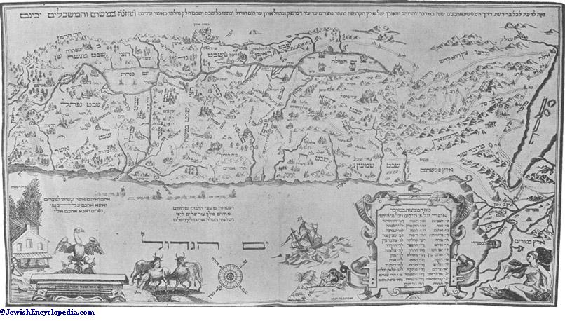
The northern part of the coastal plain, called the plain of Sharon in the Old Testament, extends from the Nahr Rubin to Mount Carmel and is much more level than the southern part. It has few considerable elevations, one of these being the hill of Jaffa, which rises from the sea. The plain is about 100 kilometers long. On the north, along the ridge of Carmel, it is very narrow, and about 30 kilometers south of the edge of Carmel, on the Nahr al-Zarḳa, it has a width of only 3 or 4 kilometers, but from this point it widens suddenly, being 12 kilometers broad at Cæsarea and 20 kilometers at Jaffa. It ascends gradually toward the mountain on the east. It is well watered, since the streams from the mountains drain into it, and it is irrigated in the north by the rivers from Mount {-}Carmel, as well as by a series of perennial brooks. The Nahr al-Zarḳa is the Crocodile River mentioned by Pliny, and its marshes still harbor some of those reptiles. The Nahr Iskandarunah forms the outlet of the large valley leading from Nablus, and the short Nahr al-Falik was made by the water collected their piercing the sand-hills on the coast for an outlet. The Nahr al-'Auja, two hours north of Jaffa, is, despite its short course, the most copious river in Palestine, next to the Jordan. Sanddunes along the greater part of the coast, however, have closed the outlet of the streams coming from the mountains and have formed marshes in many places. More important than all these rivers is the abundant supply of good water which may be obtained everywhere a short distance below the surface, and which is used for irrigation both in the orange groves of Jaffa and in the Jewish colonies in the plain.
In consequence of this abundant supply of water the plain has always been a very fertile one, although no humus has formed on the alluvial land. The plain of Sharon was famous in antiquity for its rich vegetation (comp. Isa. xxxiii. 9, xxxv. 2), and was considered good pasture-land (I Chron. xxvii. 29), while in the spring it was brilliant with flowers (comp. Cant. ii. 1). The southern part of the plain is well cultivated, and there are famous orange groves extending for many miles around Jaffa. The German colony of Sarona and several Jewish agricultural colonies are in this part of the plain. In the northern portion there are still many acres of untilled land, which is used as pasture. Among the coast towns was the ancient Dor (the modern Ṭanṭurah), the most southern settlement of the Phenicians (Josh. xi. 2, xii. 23, et al.); it now lies in ruins, as well as Cæsarea, which, built by Herod the Great, was for a time the capital of Palestine, and in whose remains, still termed Ḳaiṣariyyah, a small colony of Circassians has settled. Jaffa alone has retained its importance as the port for Jerusalem and the entire southern part of Palestine, and is steadily developing, containing more than 40,000 inhabitants in 1904.
The most northern part of the coast-line is the plain of Acre, which extends for about 35 kilometers north from Carmel to the promontory Ras al-Naḳurah of the Jabal al-Mushaḳḳah. The southern part, between the cities of Ḥaifa, at the northern foot of Carmel, and Acre, on the northern end of the finely curved Bay of Acre, extends with a width of 6 kilometers along the bay, being separated from the plain of Esdraclon only by a slight elevation. This is traversed by the Kishon (the modern Nahr al-Muḳaṭṭa'), which, like the Nahr Na'man farther north (the ancient Belus), empties into the Bay of Acre. The greater part of this region is marshy and unhealthful, and only the more elevated edges are cultivated. The smaller, northern portion of the plain north of Acre is very narrow, but fertile and well cultivated.
The West-Jordan Mountain District.
The west-Jordan mountain district extends almost in a straight line from south to north as the connecting-link between the table-land of Al-Tih, in the Sinaitic Peninsula, and the Lebanon. In consequence of the rift described above, which caused the bed of the Jordan to sink, the cretaceous layer that was originally horizontal has taken the form of a flat arch, which declines much more steeply on the east than on the west. In distinction from a mountain ridge and a level plateau, the west-Jordan mountain district may be described as a table-land of highly irregular and diversified conformation. Its most important characteristic is in the fact that the axis of the mountain range lies much nearer to the Jordan than to the sea, so that about two-thirds of the west-Jordan country lies west of the watershed. This is highly important for the hydrographic conditions of the region, since it permits the development of longer and richer valley systems westward toward the sea, some of which widen into small though fertile plains. The descent toward the east, on the contrary, is much too steep to permit such conformations. The difference in the elevation is, moreover, much greater, in view of the low level of the Jordan valley. Thus, between Hebron and Jerusalem the elevation of the ridge is from 800 to 1,000 meters, while the level of the Dead Sea is 393 meters below that of the Mediterranean, so that the entire difference is between 1,200 and 1,400 meters, although the ridge is only about 25 kilometers distant from the Dead Sea. This makes a fall of 48 or 50 meters per kilometer.
Toward the north the conformation is somewhat more favorable as regards the difference in elevation, but toward Nablus the watershed approaches to within 15 or 20 kilometers of the Jordan. Naturally, the water can not sink into the ground there, and no level valleys can be formed; the torrents carry the soil and smaller rocks down with them while rushing through the deep and nearly perpendicular cañons which they have cut out. The force of these streams should not be underestimated, although these cañons were cut in remote prehistoric times, when more rain fell in Palestine than at present. The mountain ridge is the center of the country from a physical as well as a cultural point of view, for there all the important cities were situated: Hebron, Bethlehem, Jerusalem, Beth-el, Shechem, and Samaria; and along this ridge ran the principal, or rather the only, commercial highway of the Israelitic kingdom. This circumstance, which seems strange at first sight, is easily explicable from the conformation, for there is no valley running from the north to the south, and numerous wadis, some of which are deep, run east and west from the ridge. This renders it difficult, if not impossible, to have roads north and south on the mountainsides, for they would be forced to either cross or go around the valleys; furthermore, access to the wadis was very difficult in the east and west, especially in the southern part of the country.
The Negeb.
The west-Jordan mountain district is divided into two unequal parts by the plain of Esdraelon—the mountain district of Galilee to the north, and that of Judea and Samaria to the south. A peculiarity in the conformation corresponds to this geographical division, Galilee, the northern country, being morediversified than the bare and monotonous southern part. The Judean mountains rise in the south from a bare plateau, which extends on the west side of the 'Arabah southward from the Dead Sea for about 100 kilometers. The Canaanitic portion of this area is called in the Old Testament the Negeb, or "Barren Country," a territory of indefinite boundaries. On the east the declivities toward the Dead Sea southward are comprised in the "wilderness of Judah" (see below), so that the "Salt City" (the modern Khirbat al-Milḥ), only 25 kilometers east of Beer-sheba, is occasionally included in the desert of Judah. In the north the Negeb extends as far as the mountain district proper, about half-way between Beer-sheba and Hebron, where the mountains at Al-Dahariyyah and Khirbat 'Attir (Jattir) reach an elevation of 600 or 650 meters, this entire region being much more inviting in character on account of the vegetation resulting from the greater abundance of water.
The Negeb is rightly called "barren land." Today it is a steppe on which some small cattle are raised. Only Bedouins, the Azaziwah Arabs, pitch their tents here. In ancient times it was more populous, and a number of its cities are mentioned in the Old Testament (Josh. xv. 21-22, xix. 2-8; comp. I Chron. iv. 20-33). The best known is Beersheba, the famous old sanctuary (Gen. xxi. 33, xxvi. 33, xlvi. 1), which was still a place of pilgrimage in the time of Amos, visitors coming even from the Northern Kingdom (Amos v. 5, viii. 14). This city is regarded as the southernmost frontier city of the Israelites, since no Israelites were living in places farther south in the Negeb. The city derives its name from its wells, which were of great importance in antiquity and were an object of contention between Israel and the Philistines (Gen. xxi. 30, xxvi. 34). Beer-sheba was still an important place at the time of Jerome and Eusebius, and had a Roman garrison. The old name has been preserved in its modern appellation, Khirbat Bir al-Saba'. The city of Ziklag, on the other hand, mentioned in the story of David (I Sam. xxvii. 6), has not yet been definitely identified. There are many evidences, such as terraced slopes, and dams for water-works in the valleys, that this region was formerly cultivated, at least in part.
The Judean Plateau.
The characteristic features of the west-Jordan mountain district (see above) are most prominent in Judea. This region is a plateau with a compact mass of mountains whose ridge runs in an approximately straight line northward from Hebron to Baitin, with larger or smaller plateaux to the west. There are no definite natural boundaries separating the northern part of this district from the mountains of Samaria, although the traditional boundary, set for political reasons, finds its justification in the geographical conformation. Within the Judean hill-country the group of mountains about Hebron in the south and those of Baitin in the north are marked by an elevation which sometimes reaches 1,000 meters, while the less lofty mountain district of Jerusalem does not exceed 800 meters. In the group of mountains surrounding Hebron the ridge rises in the Ṣirat al-Balla', somewhat north of the city, to an elevation of 1,027 meters, being the highest point in southern and middle Palestine. The mean elevation of the plateau is 900 meters. There are two fertile plateaux of considerable size on the west close to the watershed: in the south the plateau of Hebron, with the famous old city of Hebron, the modern Al-Khalil; and farther north the plateau of Ḥalḥul and Bet Ṣur (the Halhul and Beth-zur of Josh. xv. 58; see II Chron. xi. 7; I Macc. iv. 29, 61, et al.; Beth-zur was an important fortress during the wars of the Maccabees). The latter plateau is drained by the Wadi 'Arrub, whose source fed the aqueduct leading to the so-called "Pools of Solomon" and to Jerusalem.
Jerusalem.
The middle district of the hill-country of Jerusalem is much lower, its highest point being the Nabi Samwil, northwest of Jerusalem, 895 meters high (perhaps the ancient Mizpah in Benjamin and Samuel's seat of judgment; Josh. xviii. 25; I Sam. vii. 5 et seq.; see Ramah). At Jerusalem the watershed sinks to 817 meters, but to the north rises again to 881 meters at Baitin, where the fertility of the country is due to a number of smaller plateaux west of the watershed, as at Bethlehem and Bait Jala (a large, flourishing Christian village, half an hour northwest of Bethlehem, where the country still justifies its name [Bait Laḥm = "house of bread"]). Southwest of Jerusalem lies the plateau of Al-Biḳa', probably the plain of Rephaim, fertile in grain (Isa. xvii. 5).
Farther north from Jerusalem, somewhat more distant from the watershed, is the plain of Yalo (the Ajalon of Josh. x. 12; I Sam. xiv. 31, etc.). The water from this plain collects on the north in the Wadi Bet Ḥaninah, and on the south in the Wadi al-Ward, both of which join the Wadi al-Ṣarar, the principal valley of Judea. The railway between Jaffa and Jerusalem runs through this valley. The cities of Bethlehem and Jerusalem lie somewhat east of the watershed, while farther north, on the ridge of the mountain, are the following well-known places: "Gibeah of Saul" (I Sam. xi. 4), on the hill Tall al-Fal; Ramah in Benjamin (I Kings xv. 17; see Ramah), the modern Al-Ram; Beeroth (II Sam. iv. 2), probably the modern Al-Birah; and finally Beth-el, the pre-Israelitic sanctuary (Gen. xxviii. 11, 19) and the modern Baitin. East of Ramah lay a second Gibeah, in Benjamin (or Geba; I Sam. xiii. 16, xiv. 16, etc.), the present Jaba', and opposite it on the north side of the deep valley Wadi al-Suwainiṭ was Michmash (I Sam. xiii. 23; Isa. x. 28 et seq.), now the deserted Makhmas, while west of Ramah was situated the great Gibeon (the modern Al-Jib, with eight springs), with its famous altar (Josh. x. 2 et seq.; I Kings iii. 4 et seq.).
The third northern group, the mountain district of Beth-el, is less regular than the two preceding. Since the watershed is somewhat to the east, the road northward runs to the west of it in the parallel Wadi al-Jib. In the Tell 'Aṣur the mountain ridge again reaches an elevation of 1,011 meters. Near the watershed lies the famous old sanctuary of Shiloh (I Sam. i. 3 et seq.), the modern Sailun.
The western declivity of the Judean mountain district, at least that of the two southern groups, is differentiated from that of the more northern region by the fact that in the north the mountains slope abruptly toward the plain, while in the south there is a hill-country between the mountains and the plain of the Philistines which, as already noted, approaches the coast and is designated by the Hebrew name "Shefelah." About half-way down the slope, and between 20 and 25 kilometers west of the ridge, the mountains are cut off from the plain by a series of secondary valleys, which meet the principal valleys running east and west at right angles and form together, as members of the same system, a line from north to south, parallel to the great rift of the Jordan.
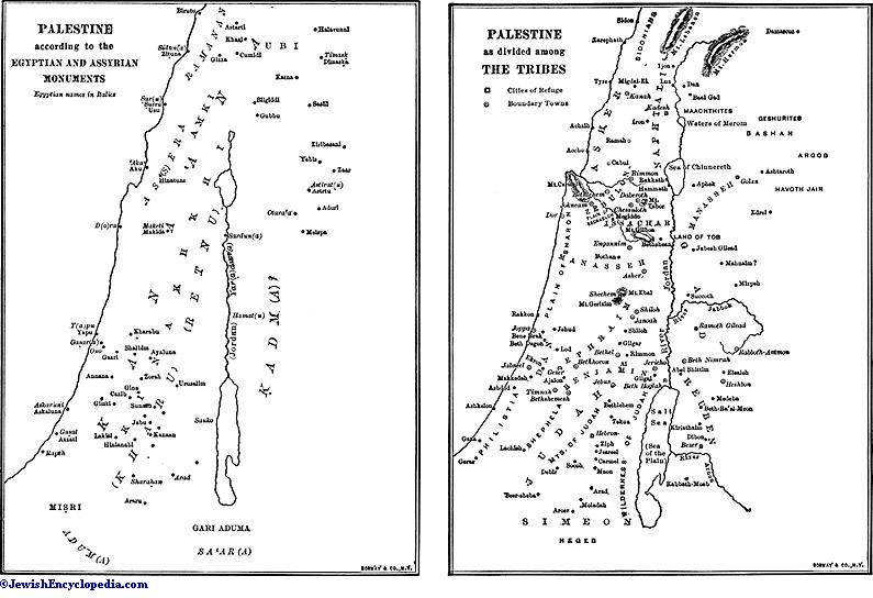
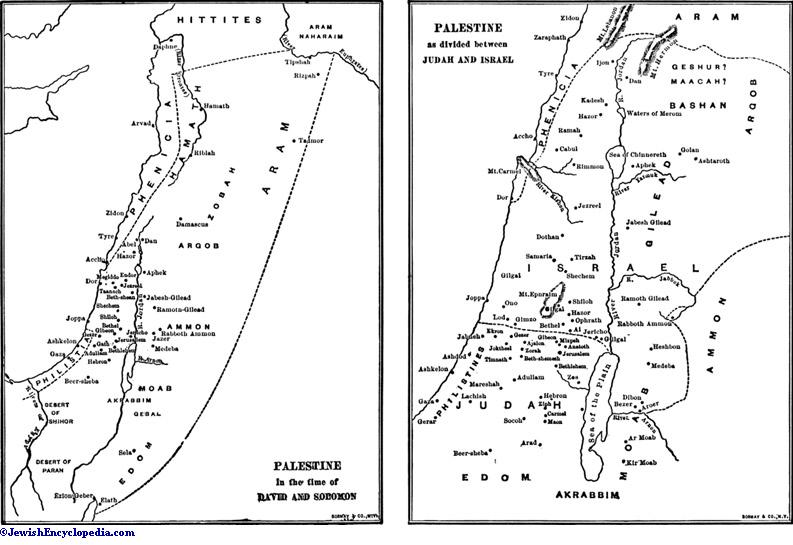
The Desert of Judah.
The eastern slope of the Judean mountain district also shows these lines running north and south. It has three terraces in the south, while the northern system has but two, these also being generally parallel to the watershed and corresponding to the conformation of the country. In the Old Testament this eastern slope is called the "wilderness" of Judah (Josh. xv. 61), which has never been of importance in history. It is for the greater part a barren desert, only a few small plains being covered with sparse grass in the spring, while elsewhere the calcareous rock with its strata of flint lies bare. Cañons pierce the declivity, and the passage downward is difficult.
The mountains of Samaria form, as noted above, a continuation of those of Judea, but since its physical conformation is different, a geographical separation is justified. Instead of a narrow plateau sloping toward the west and east with sharply defined boundary-lines, one finds, on going farther northward, a conformation of increasing variety. Central Palestine (Samaria) is, therefore, the natural transition between Judea and the mountains of northern Palestine. The change becomes apparent in southern Samaria, which may be said to extend northward as far as the Wadi al-Sha'ir, the principal valley of Samaria, connecting the mountains with the coast (see above). There the watershed no longer runs in a straight line north and south, but changes its direction frequently. North of Tell 'Aṣur it turns at first to the northeast, approaches within 15 or 20 kilometers of the Jordan, and then runs north until near Nablus, turning toward the west at Gerizim, the present Jabal al-Ṭur (870 meters). Then it traverses as a very low ridge the plain between Gerizim and Ebal, east of the present Nablus, ascends the Ebal (Jabal Aslamiyyah, 938 meters), and runs thence farther north. While Ebal is entirely bare, a number of large springs are found at the northern foot of Gerizim, which make the vicinity of Nblus one of the most fertile regions of all Palestine.
The northern foot of Gerizim also is covered with vegetation, so that Ebal was the mountain of cursing, while Gerizim was the mountain of blessing (Deut. xi. 29, xxvii. 12 et seq.). Shechem lay on the watershed ("shekem" = "shoulder"), east of the present Nablus, which corresponds to the ancient (Flavia) Neapolis, a name given to the city when it was rebuilt after the war of Vespasian, this being one of the rare cases in which a Roman local name has replaced the ancient Semitic one. On the eastern slope of Gerizim, and before the great gate to the west between it and Ebal, spreads the large plain of Al-Makhnah, with an area of about 20 square kilometers; and on the northeast, and connected with it, is the plain of Salim, a fertile grain-country, surrounded by finely formed mountains covered with olive-trees.
Mount Ebal marks the southern boundary of the mountains of northern Samaria, whence the ridge extends first north and then northeast to the Jabal Faḳu'ah, the Old Testament mountains of Gilboa (I Sam. xxxi. 1; II Sam. i. 21). This elevation, extending in the shape of a crescent from southeast to northwest, forms in a certain sense the terminal point of the range. It slopes steeply toward the Jordan, and to the brook of Jalud (see below) and the plain of Jezreel. On the northern side, however, there are numerous small plains set in the mountain-side, such as those of Al-Fandaḳumiyyah, 'Arabah with Tell Dotan (the Dothan of Gen. xxxvii. 14-17), and Marj al-Gharaḳ, which forms in winter a large marshy region with no drainage, although it dries up in the summer, leaving a field for cultivating grain. The eastern slope of the mountains of Samaria is more varied than in the south; instead of the terraces parallel with the ridge, four mountain ranges about 20 kilometers long run from northwest to southeast, almost to the Jordan. The beautiful wide valleys between them are very fertile, the most important one being the Wadi Far'ah, south of the Ḳarn Ṣarṭabah. The most southern of these ranges ends in the Ḳarn Ṣarṭabah, 379 meters above the sea, and about 679 meters above the Jordan valley, of which it forms the great landmark.
Mount Carmel.
On the northwest there is another outlying range of hills, reaching an elevation of 518 meters in the Shaikh Iskandar, which, together with its continuation, the Bilad al-Ruḥah, connects the mountain country with Mount Carmel. Otherwise Carmel occupies a position apart, being separated from the rest of the mountains by two deep valleys, the Wadi al-Milḥ and the Wadi al-Maṭabin. It consists of a wooded range with its axis running from southeast to northwest; it is widest at the southeast end and narrows to a point at the northwest. It reaches its highest elevation in the southeastern part, near the wide base of the mountain at Asfiyyah (552 meters). Thence the ridge declines slowly and evenly to the convent of Carmel on the northwestern point (169 meters), sloping abruptly to the sea at an angle of 35 degrees. The slope toward the plain of Esdraelon also is a steep one, while it is merged into wooded hills on the southwest. Owing to its abundant supply of water, and especially to the heavy dew, it is covered with luxuriant vegetation, remaining green even through the summer, hence its name Carmel (= "garden," "grove"; comp. Amos i. 2; Jer. iv. 26; Isa. xxxv. 2). It is covered with holm-oaks and pine-trees, although here, as elsewhere in Palestine, the trees are for the most part small. In spite of its fertility Mount Carmel is now deserted, having only two villages, Asfiyyah and Daliyyah, although but a century ago there were numerous others here. There are many caves in the gray calcareous rock,especially on the side toward the coast, so that in olden times Mount Carmel was considered a safe place of refuge for the persecuted (Amos ix. 3). Much game is found there, as gazels and partridges, deer and tiger-cats.
The Plain of Esdraelon.
The mountain country of Samaria is separated from Galilee by a deep plain extending from the sea to the valley of the Jordan. The central portion was the ancient plain of Esdraelon, its modern name being Marj ibn 'Amir. On the west it is connected with the plain of Acre. Spurs of the mountains of Galilee extend toward the southeast foot of Carmel, separating the two plains, and leaving only a narrow passage for the Kishon. Toward the east the plain continues in the valley of the Nahr Jalud, where the range of Gilboa is again connected with the mountains of Galilee by a low ridge, with an altitude of 123 meters, running northward and forming the eastern boundary of the plain. On it lies the ancient royal city of Jezreel (I Kings xviii. 45 et passim), the modern Zar'in. There the Nahr Jalud, which has its source half an hour east of Zar'in, begins to descend in a rapidly widening bed, reaching the valley of the Jordan at Baisan. This sloping bed of the brook of Jezreel is referred to in the Old Testament under the name of the "valley of Jezreel" (Josh. xvii. 16; Hos. i. 5), while the plain now bearing that name and extending west of Zar'in to the coastal plain corresponds to the ancient "valley of Megiddo" (II Chron. xxxv. 22), or, simply, the "great plain" (I Macc. xii. 49).
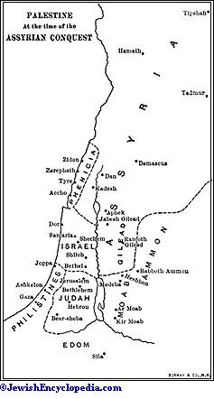
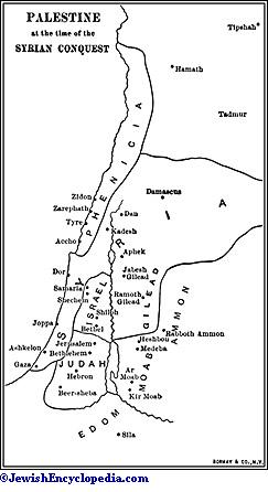
This latter plain is in form a rectangular triangle; the shortest side on the east running almost directly from south to north, and extending along the ridge of Zar'in (see above) from Janin to Mount Nabi Daḥi, or little Mount Hermon, and to Mount Tabor, the northeast corner. Its northern edge runs almost directly west along the southern edge of the mountain of Nazareth to the bed of the Kishon (see above) and Mount Carmel. The hypotenuse extends thence southeast along the slope of Carmel, the Bilad al-Ruḥah, and the other Samaritan mountains. It rises eastward gradually and evenly from the bed of the stream at an elevation of about 25 meters, and at Zar'in reaches a height of 123 meters. The plain itself is drained by the Nahr al-Muḳaṭṭa', the ancient Kishon (Judges v. 19 et seq.), which, with its network of tributaries, gathers up all the water from the mountain slopes. The river is continuously full only to the point where it breaks through the mountains; in the plain it dries up in the summer, while in winter the drainage there is not sufficient, and numerous large morasses are formed. There are, consequently, no settlements in the plain itself, all villages being built, now as in antiquity, in thehigher districts. In the southeast corner of the plain, near a large spring and amid gardens and palms, lies the city of Janin, the Ginæa mentioned by Josephus, and perhaps the En-gannim (Josh. xix. 21, xxi. 29) and Beth ha-Gan (II Kings ix. 27) of the Old Testament. Zar'in on the eastern edge has already been mentioned.
Farther north are Sulam—the ancient Shunem (Josh. xix. 18; I Kings i. 3; et al.)—on the southern foot of the Nabi Daḥi, the wretched village of Nain on the northern foot of the same mountain (Luke vii. 11 et seq.), and toward the east the small Endur (the ancient En-dor; Josh. xvii. 11; I Sam. xxviii. 7). Along the northern edge are Daburiyyah (the Daberath of Josh. xix. 12), Iksal (the Chesulloth of Josh. xix. 18), and Jabatah (the ancient Gabbatha). On the southern side the ancient Jokneam (Josh. xii. 22) rises near the western corner of the Tell Ḳaimun. Then follow the two principal towns of the plain, Megiddo and Taanach, both of them ancient fortresses. Megiddo, called "Maketi" by the Egyptians and "Legio" by the Romans, corresponds to the modern Al-Lajjun. The great highway from Egypt entered the plain there, protected by the fortresses. In pre-Roman times the city lay on the neighboring hill of Tell al-Mutasallim (recently excavated by the German Palästina-Verein; comp. Josh. xii. 21; II Kings xxiii. 29 et seq.). Taanach (Judges v. 19; I Kings iv. 12; et al.), the modern Tell Ta'anuk, three or four Roman miles east of Legio, protected the eastern portion of the road. The entire plain, with its dark-brown soil, broken in many places by black basalt, is very fertile and well cultivated, and looks like a sea of grain in summer. In antiquity it was the great battle-field of Palestine (comp. Judges v. 19 et seq., vii. 1 et seq.; I Sam. xxxi. 1 et seq.; I Kings xx. 26 et seq.; II Kings xxiii. 29); the French, under Kleber, also fought a bloody battle there with the Turks in 1799.
Galilee.
The mountains of Galilee, as already stated, are but loosely connected with Samaria by the low ridge of Zar'in. This conformation of the country has left its mark in history, for it is no accident that Galilee has always preserved an attitude of comparative independence toward the more southern districts. Since the time of Josephus, Upper Galilee in the north has been separated from Lower Galilee in the south, the two being entirely different in character.
The most peculiar characteristic of southern Galilee is the system of four parallel ridges which form the mountain country and run from west to east at right angles to the more southerly mountains and the line of the watershed. These ridges are separated from one another by wide valleys and small plains. The most southerly ridge is the Nabi Daḥi, also called Little Hermon, in which the range reaches an elevation of 515 meters. The hilly plateau slopes abruptly toward the Jordan, rising sharply in the west from the plain of Esdraelon, and is bounded on the south by the valley of the Nahr Jalud, and on the north by the Wadi al-Birah. The second ridge is the hill-country of Nazareth; it begins with the low hills at the gap of the Kishon, rises in the Jabal al-Sikh, north of Nazareth, to an elevation of 560 meters—the highest point being Tabor, a finely rounded cone rising in almost complete isolation from the plain of Esdraelon to an elevation of 562 meters—slopes to 358 meters in the outer mountains on the Jordan, and then falls abruptly to the valley. The small plain of the Wadi al-Rummanah, which flows toward the west, and, farther east, the larger and lower Sahal al-Aḥma divide this group from the third group, the hill-country of Ṭur'an. This reaches its highest elevation in the mountain of the same name; on the east the Ḳarn Haṭṭin (316 meters) and Al-Manarah (294 meters), above the Lake of Tiberias, belong to it, the slope of both being toward that lake. In the east all these ranges bend in a crescent toward the south, thus producing a remarkable parallelism to the ranges of northern Samaria which run from the ridge toward the Jordan (see above).
The fourth or northernmost group is the plateau of Al-Shaghur, which is separated on the south from the hill-country of Ṭur'an by the plain of Sahal al-Baṭṭuf (the ancient plain of Asochis in Josephus) and the deep Wadi al-Ḥammam, which extends to the Lake of Tiberias. The range begins in the west at the large village of Shafa 'Amr. Its highest tops are the Jabal al-Daidabah (543 meters) and the Ras Kruman (554 meters). The plateau north of this range is the plain of 'Arabah, which is bordered on the north by a rather low ridge. The northern boundary of this plateau of Al-Shaghur, and of southern Galilee as well, is the plain of Ramah, about 370 meters above sea-level, and which drains toward the sea and the Lake of Tiberias. It is evident from the preceding description that the watershed of Lower Galilee does not run in a straight line, but winds east and west.
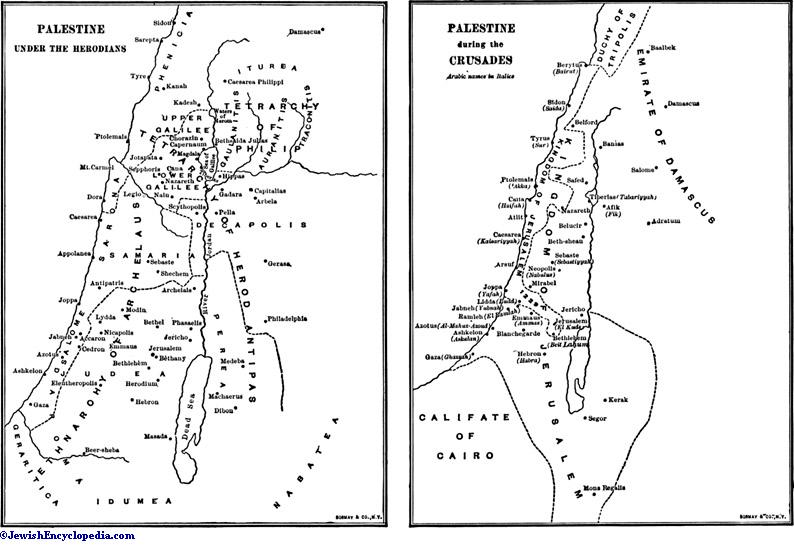
Upper Galilee is a plateau in the form of an irregular square, bordered on all four sides by chains of hills and intersected by two mountain ranges. It is highest and widest in the south and slopes gradually but perceptibly toward the north to the Nahr al-Ḳasimiyyah. The most southerly range begins near Acre and rises in a steep grade to a considerable height in the Nabi Haidar (1,049 meters) and the Jabalat al-'Arus (1,073 meters). There lies Safed, the highest city in Palestine (838 meters), mentioned as early as the Talmud and inhabited chiefly by Jews, who look upon it as a holy city, since, according to tradition, it is there that the Messiah will appear. The western edge begins somewhat west of Nabi Haidar (see above), and runs northward almost parallel to the coast. The declivity toward the slope is somewhat steep, although several valleys break through it and connect the plateau with the coast. The eastern edge begins at the mountains at Safed and runs in part in parallel ridges with small plains interspersed to the Jabal Hunin (900 meters), where the northern edge, sloping toward the Nahr al-Ḳasimiyyah, turns west. Among the mountain ranges in the interior of the plateau the one which runs northwest from the Jabal al-'Arus is especially noteworthy, for to it belongs the highest mountain of Palestine, the Jabal Jarmaḳ (1,199 meters), west of Safed. The watershed in Upper Galilee runs for a considerable distance along the mountains of the eastern border, so that the ridge of the mountain slopes without intersecting ranges toward the plain of the Jordan.
The Jordan Valley and Sources.
The origin and extent of the great dip have been discussed above. The Hebrews called the valley from the Lake of Tiberias to the Red Sea the 'Arabah Steppe. The Arabs term the valley from the Lake of Tiberias to the Dead Sea, and the district on the southern end of the latter, Al-Ghur, and its continuation toward the south is still designated as Al-'Arabah. The Jordan itself (Ha-Yarden) is commonly said to have derived its name (= "the descender") from its rapid course, although this etymology is very doubtful. It is also called Al-Urdunn by the Arabs, although its more usual name is Shari'at al-Kabirah (= "the great watering-place"), or simply Al-Shari'ah (= "the watering-place").
The Jordan has three sources, all of them at the foot of Mount Hermon. The most distant one lies outside of Palestine near Ḥaṣbaiyah, on the western foot of Mount Hermon, 520 meters above the sea. The Nahr Ḥaṣbani, as the stream is there called, flows rapidly southward along the eastern edge of the plain of Marj 'Ayun (perhaps the Ijon of I Kings xv. 20). The second source is the Nahr al-Laddan, called by Josephus the Lesser Jordan, which is fed by two sources from the Tell al-Ḳaḍi, the ancient Dan (see above), 154 meters above the sea. This source is the largest, having three times as much water as the Ḥaṣbani and twice as much as the Nahr Baniyas. This latter source emerges as a large brook from a grotto (329 meters), formerly sacred to Pan, at the foot of the mountain of the Castle of Baniyas, the ancient Paneas, which was subsequently called Cæsarea Philippi. About 8 kilometers south of the Tell al-Ḳaḍi, 43 meters above the sea, these three streams unite, forming a river about 14 meters in width.
The Lake of Ḥulah.
As far as the Lake of Ḥulah the valley of the Jordan is a beautiful plain, 10 kilometers wide, called Arḍ al-Ḥulah; it is watered by numerous brooks, with many marshy places, covered with reed and papyrus plants, in the central district, although otherwise it is very fertile. The marshy country ends in the south in the Baḥr al-Ḥulah, a triangular basin with its surface about 2 meters above the sea and with an extreme width of 5.2 kilometers and an extreme length of 5.8 kilometers, its depth varying from 3 to 5 meters. Josephus calls the entire district Ulatha (
Lake of Tiberias.
The Lake of Tiberias, called Chinnereth in the Old Testament, and Gennesaret, or the Sea of Galilee, in the New, has the form of an irregular oval, with an extreme width of 10 kilometers in the northern half, an extreme length of 21 kilometers from north to south, and an area of 170 square kilometers. It is 208 meters below the Mediterranean, and its depth varies from 50 to 70 meters, according to the season. Its brachiate form is due to the fact that the steep southern coast recedes slowly toward the south in consequence of the erosive activity of the waters of the Jordan, while the silt of the river is deposited in the north. It does not derive its name Chinnereth from its shape, which resembles the form of a "kinnor" (= "harp"), but from the city or district of that name (Josh. xix. 35; I Kings xv. 20). Similarly, Gennesar was the name of a small district on the western side, probably the same plain that was once called Chinnereth, although it now bears the name of Baḥr Ṭabariyyah, after the city of Tiberias. On the eastern side the mountains approach very closely to the lake, but in the north, where the Jordan empties into it, there is a small plain called Al-Abṭiḥah, or Al-Baṭiḥah, about 7 kilometers from east to west and between 2 and 5 kilometers in width, well watered and fertile, where stood the city of Bethsaida Julias. The bank on the west is wider, and in ancient times it contained a number of towns. In the north lay Capernaum, with a Roman toll-gate and garrison. This city, frequently mentioned in the New Testament as a center of the activity of Jesus, and called Kephar Nome by Josephus, is the modern Tell Ḥum, 4 or 5 kilometers west of the mouth of the Jordan. The plain of Gennezar (the modern Al-Ghuwair) extends from Khan Minyah southward to the deep Wadi al-Ḥamam, 5 kilometers in length by 1.5 kilometers in width, and once famous for its fertility, being praised by Josephus and in the Talmud. Gennezar, Magdala, and Taricheæ are the best-known places there. Farther south, where the mountains again approach the lake more closely, lies Tiberias (Ṭabariyyah, called Raḳḳat in the Talmud), being separated from the plain to the north by a rocky headland; an hour farther south are the hot springs of Hamath. The Castle of Sennabris (the modern Sinn al-Nabra) defends the road against the southern end of the lake.
Lower Course of the Jordan.
From the Lake of Tiberias to the Dead Sea the Jordan has a length of about 110 kilometers in a straight line, with a fall of 186 meters—from 208 to 394 meters below sea-level. This results in a number of very sharp turns in the soft marly and loamy soil; and as the river carries away a large amount of this soil it has a muddy-yellow color. The valley varies in width; at the head of Lake Tiberias it is only about 4 kilometers wide; on the east side of the river it widens gradually; and on the west side it broadens at intervals into plains, as those of Baisan, Phasælis, and Jericho, with a width of 24 kilometers, while in other places it contracts to a narrow strip where the mountains approach the river. The stream has made a bottom for itself without sharp turns in this soft soil, about 15 meters deep, although the width and depth vary. The channel itself is between 3 and 4 metersdeep, with an average width of 30 meters, and with very sharp turns, the course varying greatly in consequence of the soft soil and the large fall, so that the bridge at Al-Damiyah, built in the thirteenth century (see below), is now 38 meters from the water. The river-bottom of the Jordan is called Al-Zur by the Arabs, as contrasted with Al-Ghur, which, as already stated, designates the entire dip. The valley is covered with a thick growth of trees and shrubs, in which animals abound, including wild boars, while lions were found there in antiquity (Jer. xlix. 19). It is also called the "pride of Jordan" by the prophet (Zech. xi. 3) on account of the contrast between its refreshing verdure and its barren surroundings. This bottom is frequently inundated in the rainy season, but the river does not enter the plain above, even during very high water, so that the valley has always been barren and unproductive. Settlements are possible, now as in antiquity, only along the edge of the valley, where other springs and brooks come from the mountains.
The intercourse of the two banks of the river is facilitated by fords, of which there are five between the Lake of Ḥulah and the Lake of Tiberias, while between the latter and the Dead Sea there are fifty-four. The ford of Al-Damiyah, near the mouth of the Nahr al-Zarḳa, corresponds to the Ma'beh ha-Adamah of I Kings vii. 46, and that of Makhaḍat 'Abarah, north of the mouth of the Nahr Jalud, corresponds to the Bethbara of Judges vii. 24 (which is to be emended accordingly) and John i. 28. These fords, however, can not be used in the winter, when the river is full. There are two bridges, in addition to the one already mentioned, dating from the Middle Ages: the "bridge of Jacob's daughters" and the Jisr al-Mujami', about 10 kilometers south of the Lake of Tiberias. A small bridge has recently been built at Jericho by the Turkish government.
Tributaries of the Jordan.
Most of the numerous wadis which enter the Jordan valley from the western and the eastern mountain district are only winter brooks, and even the perennial streams carry little water down to the Jordan, for much of it evaporates in the valley or sinks into the soil. The following two may be mentioned on the left or eastern side: the Shari'at al-Manaḍirah and the Nahr al-Zarḳa. The Shari'at al-Manaḍirah enters the Jordan a short distance south from the point where the Jordan leaves the Lake of Tiberias. This river, the Hieromyces of the Greeks and the Yarmuḳ of the Talmud, rises in the Ḥauran, and is the largest tributary of the Jordan, containing nearly as much water as the latter. The Nahr al-Zarḳa ("Blue River"), the ancient Jabbok (Gen. xxxii. 22; Num. xxi. 24; Josh. xii. 2), enters the Jordan farther south, about half-way between the Lake of Tiberias and the Dead Sea. Before crossing the plain to enter the Jordan it flows for quite a distance parallel to that river and along the foot of the mountains.
The plain of the right or western side broadens out triangularly where the larger brooks come down from the mountains. Thus the famous oasis of Baisan, the Scythopolis of the Greeks and the Beth-shean of the Old Testament (Judges i. 27; I Sam. xxxi. 7 et seq.), is formed at the mouth of the Nahr Jalud (see above); this is a well-watered and fertile plain in the form of a rectangular triangle, whose sides run from east to west and from north to south and are about 20 kilometers long. Much smaller are the two plains north and south of the mouth of the Ḳarn Ṣarṭabab (see above). On the north the Wadi Fari'ah comes down from the region of Nablus, and on the southwest the Wadi al-Ifjim. The former runs for a long stretch parallel to the Jordan before it is able to break through the high banks of the river. The oasis of the ancient Phasælis, now the ruins of Khirbat Fasa'il, belongs to the district of the mouth of the Ḳarn Ṣarṭabah. From this point the plain of the Jordan continues wide on the west side, for the plain of Jericho, traversed by the lower course of the Wadi al-Ḳalt, joins it without intervening mountains. In the time of Herod the plain was well watered and settled, and famous for its balsam and other products. The spring of 'Ain al-Sulḥan, according to tradition the spring of Elisha mentioned in II Kings ii. 19 et seq., is the most important of the perennial springs to which the oasis has owed its existence since ancient times. In the Old Testament this most southern part of the Jordan valley is called 'Arbot Yeriḥo (plains of Jericho), or, on the other side east of the Jordan, 'Arbot Mo'ab (plains of Moab). In like manner Abel-shittim (acacia meadow) must have been east of the Jordan. For further details see Jericho.
Dead Sea.
The reservoir for the waters of the Jordan, the Dead Sea, occupies the lowest portion of the valley, its surface being 393.8 meters below sea-level. It has an extreme depth of 399 meters, so that the extreme depth of the rift is 792.8 meters below the level of the Mediterranean. The northern part is deeper than the southern, which is only from 1 to 6 meters deep and is separated from the northern by the peninsula Al-Lisan, running out from the east. The water-level varies from 4 to 6 meters, according to the season. The area of the southern part is considerably enlarged in the rainy season, when the entire Sabkhah is flooded. The extreme length of the Dead Sea, from north to south, is 76 kilometers, and its greatest width, south of the Wadi Mujib, is 15.7 kilometers, while the peninsula of Al-Lisan reduces its width at that point to 4.5 meters (comp. the Lashon in the south of the sea, mentioned by Josh. xv. 2 et seq.). On the north and south the country behind the banks is entirely level, but on the east and west the steep mountains approach the sea so closely that in some places there is not even space for a foot-path. The eastern edge runs in a straight line from north to south; here the mountains rise between 800 and 1,100 meters above the Mediterranean, or from 1,200 to 1,400 meters above the Dead Sea, toward which they slope steeply. The western edge is more diversified and is considerably lower, being only between 500 and 570 meters above the Dead Sea, from which it recedes somewhat in most places. The fresh-water springs 'Ain Fashkhah and, farther south, 'Ain Jidi (the ancient Engedi) produce small oases in the plain along the bank. The mountain fortress of Masada, opposite the peninsula of Al-Lisan, built byJonathan Maccabeus and refortified by Herod, is famous in later Jewish history. An interesting object at the extreme southwest point of the sea is the isolated salt mountain of Jabal Usdum, 11 meters long and about 45 meters high, which consists almost entirely of pure salt, and where, according to Josephus, was shown Lot's wife turned to a pillar of salt (comp. Gen. xix. 29; Wisdom x. 7). Fresh water is carried to the Dead Sea only by a few rivers from the east, the most important, next to the Jordan, being the Wadi al-Mujib (the ancient Arnon). It is but natural that legends of all kinds should have become connected with so strange a natural phenomenon as the Dead Sea. The stories of the destruction of Sodom and Gomorrah may, for instance, have been based on prehistoric geological events, but the problem can not be discussed here. On the origin of the Dead Sea and the curious composition of its water compare the article Dead Sea.
The East-Jordan Country.
The northern part of the east-Jordan country has been surveyed by the German Palästina-Verein, although most of the maps and reports are as yet unpublished, while only a small section of the southern part has been surveyed by the Palestine Exploration Fund, by which maps have been issued. A description of the country on the basis of the material now accessible is merely a repetition of a few known facts. The Wadi al-Ḥaṣa (or al-Aḥṣa), the ancient Zared or Zered, forms the southern boundary, as explained above, since it is the natural dividing line between the ancient Moab and Edom (Num. xxi. 12; Deut. ii. 13; comp. verse 18). The region extending from the Wadi al-Ḥaṣa to the Wadi al-Sha'ib may be taken together as the most southerly portion, which has a uniform character. In the Old Testament (Deut. iii. 10, Hebr.) this district is called Mishor (corresponding to the Moabitic plain), in contradistinction to the more northerly region; only the northern part of this plain was, temporarily, in the possession of the Israelites. The name correctly characterizes the nature of the country; it is a plateau, with an elevation of about 1,000 meters in the southern and 800 or 900 meters in the northern part; it slopes to the desert in the east with no sharp dividing line, although it falls steeply toward the west. Three large wadis start in the east as low rifts, but soon develop into deep chasms, with almost vertical sides where they reach the Dead Sea. These are: in the south, the Wadi al-Karak, receiving its name from the city of Al-Karak (the ancient Kir Moab), which it passes; in the north, the Wadi al-Mujib (the ancient Arnon), already mentioned, and the largest of the three; and finally the Wadi Zarḳa Ma'in, containing the hot springs of Callirrhoe a few hours above its mouth. For details concerning the district and its cities see Moab.
The Mountain of Gilead.
The small district extending northward to the Nahr al-Zarḳa is called Jabal Jil'ad, a form which preserves the ancient name of Gilead. The highest point of this range running from west to east lies in the western part, and is the Jabal Usha', 1,096 meters high, with a magnificent view over a large part of Palestine. On the west the ridge slopes down to a somewhat extensive plateau, the Al-Buḳai'ah, about 610 meters high, with mountains of considerable altitude on its southern border. The Nahr al-Zarḳa flows at the foot of the Jabal Jil'ad, along the northern and eastern sides and a part of the southern, since in its upper course it runs from west to east, turning with a large bend, at the southeast end of the plateau, to the north, where it descends the moderately steep northern slope of the mountains of Gilead and runs thence west to the Jordan. The district between the Nahr al-Zarḳa on the north and the Wadi al-Mujib on the south is now called Al-Balḳa.
'Ajlun.
The district of 'Ajlun extends north of the Nahr al-Zarḳa to the Yarmuḳ, and the ridge of the range of Jabal 'Ajlun runs from north to south, toward which it rises. Being situated in the eastern part of the district, it forms the watershed between the streams flowing west, directly to the Jordan, and the tributaries of the Yarmuḳ. This river also rises on the eastern side of the mountains, rather far to the south, and runs as the Wadi Warran and the Wadi Shallalah for a considerable distance to the north, forming a deep bed before it turns to the west. In a small valley near the banks of the river and somewhat above the place where it leaves the mountains to enter the plain of the Jordan are the hot springs of Al-Ḥammi, 176 meters below the Mediterranean. On the east the Jabal 'Ajlun is merged in a rolling hill-country about 12 or 15 kilometers wide, which is called Bilad al-Ṣuwait in the north and Jabal Kafkafa in the south. The steppe Al-Ḥamad adjoins it on the east. The Jabal 'Ajlun is, on the whole, well wooded and has many springs, like the plateau, which extends west of the ridge to the steep and generally bare declivities on the Jordan.
The Jaulan.
The final portion of the east-Jordan country, the district of the Yarmuḳ, extends farther east than any other part of the cultivable strip between the Jordan and the desert, reaching to the mountains of the Ḥauran. On the north Hermon is the boundary, as already stated, while farther east the district of Jaidur separates it from the plain of Damascus. This northern portion of the east-Jordan country has never had a general name, but the following four districts, from west to east, may be distinguished: Jaulan, Al-Nuḳrah, Lajah, and Jabal Ḥauran, which differ radically from one another. The Jaulan derives its name from the ancient city of Golan (Josh. xx. 8), called Gaulanitis by Josephus, while in the Old Testament the districts of Geshuri and Maachah (Josh. xiii. 1; II Sam. x. 6, 8, etc.) correspond to it. It forms a plateau between the Yarmuḳ and Hermon; it is highest in the north, and slopes toward the south, its mean elevation being about 700 meters. Its highest points are a number of extinct volcanoes, which run in a chain parallel to the Wadi al-Ruḳḳad and include Tell al-Shaikhah (1,294 meters) and Tell Abu al-Nada (1,157 meters). Broken pieces of lava from these volcanoes cover the northern and middle portions of the Jaulan, so that the "stony" Jaulan is distinguished from the "level" Jaulan inthe south. Despite its name, the stony Jaulan offers good and abundant pasture in the spring, and it is cultivated and very fertile where it is free from stones. In the level Jaulan the masses of lava have become decomposed, producing an extremely rich and dark-brown lava soil, which is found also in the Nuḳrah. East of northern Jaulan, beyond the Wadi al-Ruḳḳad and north of the Nuḳrah, extends the plateau of Al-Jaidur, whose southern slope toward the Nuḳrah is perhaps included in the Bashan of the Old Testament.
Bashan, Lajah, and the Ḥauran.
Bashan proper is identical with Al-Nuḳrah, or the plain of the Ḥauran, so called in contradistinction to the mountains of the Ḥauran. It practically corresponds to the ancient provinces of Batanæa and Auranitis, and the name Bashan (Greek Basanitis or Batanaia) designates a fertile plain free from stones. Among the Bedouins the word "nuḳrah" designates the hollow in the tent for the fireplace, and it has been given to this region on account of its sunken situation among the hills. On the references in the Bible see Bashan. The Nuḳrah, which is bounded on the east by the Lajah and the mountains of the Ḥauran, and on the south by the steppe of Al-Ḥamad, is a wide plain, gradually rising from an elevation of 550 meters in the west to 880 meters in the east, a distance of about 42 kilometers. Large perennial streams are found in the southern part, the Wadi al-Zaidi (the southern boundary toward the steppe) and the Wadi al-Dahab, rising in the mountains of the Ḥauran and emptying into the Yarmuḳ. There are few springs in the plain, but a heavy dew falls in the summer, and it is covered, moreover, by the fertile red-brown loam resulting from the decomposition of the lava from the craters of the Ḥauran, which gives a loose and easily arable soil that drinks in all moisture with avidity. The plain is famous, therefore, for its fertility, and is the granary of Syria. The wheat grown there, which is nearly transparent, brings the highest price, while barley, durrah (white maize), and "kursannah" (a food for camels) also are cultivated.
The Lajah, which borders the Nuḳrah on the northeast, is the ancient Trachonitis, a rugged, almost inaccessible plateau covered with lava from the crater of the Ghararat al-Ḳibliyyah (1,211 meters). South of the Lajah and east of the Nuḳrah rise the mountains of the Ḥauran (Jabal Ḥauran, called also Jabal Druz, or mountain of the Druses, since many Druses from the Lebanon sought refuge there in 1861). It may be the Salmon of the Old Testament (Ps. lxviii. 15 [A. V. 14] et seq.) and the Asalmanos of the Greeks. The Ḥauran forms a somewhat wide plateau, part of which has an elevation of 1,500 meters, but the various peaks rise considerably above it, the central and northern portions having the highest—Tell al-Jainah (1,802 meters), Jabal al-Ḳulaib (1,724 meters), Tell Juwailil (1,749 meters), and others, all of which are extinct volcanoes.
Geology.
All the mountains of Palestine are composed of chalk formations. The oldest strata, in the so-called Nubian sandstone, appear only in the fractures along the eastern edge of the Dead Sea and of the 'Arabah. Under this are sandstone and dolomitic limestone of the Carboniferous age, beneath which appears a breccial conglomerate stratified by lodes and veins of porphyrite and diorite. These are the oldest rocks of Palestine. Elsewhere the rocks which are exposed to view belong to the Cenomanian, Turonian, and Senonian divisions of the Upper Cretaceous. Frequent mention is made of the extensive basalt beds, part of which may belong to the Tertiary period, especially those which are found in the higher chalk plateaux, while those in the deep valley-plains belong to the later diluvian epoch, since these valleys were not formed until after the Dead Sea acquired its present level. No lava is found in the west-Jordan district south of the plain of Esdraelon, which, however, contains basalt from the crater of the Tell al-'Ajjul, in Al-Daḥi. North of that point basalt occurs more frequently in the eastern half, so that northeast of Tabor and between Nazareth and Tiberias there are large stretches of reddish-brown, decomposed lava, while the Ḳarn Ḥaṭṭin (see above) is a basalt peak.
The Jabal Ṣafad contains the principal crater, from which immense streams of lava flowed eastward. Volcanic action is most apparent in the east-Jordan country. The northern Jaulan and the mountains of the Ḥauran contain many craters, which inundated large districts with their lava, such as that of the Lajah (see above). Basalt is also scattered over several portions of the Moabitic plain, as at Diban and the Jabal Shiḥan, while the hot springs already mentioned are also proofs of volcanic activity. This was doubtless pre-psychozoic, even in so far as the formation belongs to the late diluvian epoch. Finally, the immense diluvial deposits must be mentioned. The entire coastal plain of Sharon and the Shefelah are covered with such deposits, which extend in the south beyond Beer-sheba, although they occur also throughout the lower Jordan valley, and owe their origin to the great lake which once existed there (see above). To this must be added the alluvial dunes on the coast, and the river deposits.
There are numberless caves found in the calcareous surface of the country, the best known being those at Bait Jibrin; many of these have been artificially enlarged to serve as habitations, as was frequently the practise in remote antiquity. These caves have always been used as burial-places also.
Fertility.
The arable land varies greatly in quality. The soil produced by the decomposition of lava is fertile, though, like the plain of Al-Nuḳrah, it requires much moisture. The alluvial land of the coastal plain, being reddish sand with reddish clay, is well adapted to the cultivation of many plants, such as lemons and oranges. In the mountain district west of the Jordan the formation of humus by the decomposition of animal or vegetable matter is out of the question, and it is also inconsiderable in the east-Jordan country. A red clayey soil is formed, however, by the decomposition of the soft stone under the influence of air and moisture, and this remains wherever it finds a bed in the hollows of the rock which save it from being washed away by the rains of winter. It becomes one of the principal tasks of agriculture to retain it on the slopes by means of terraces andwalls. This soil, which constitutes the principal element, repays cultivation where it has sufficient water, although it is only moderately productive, for Palestine has never been a very fertile country. In the mountains of Judah wheat generally produces a double or treble crop in the year; but there the land is very level and dries out quickly. Under favorable conditions wheat produces fourfold and barley fivefold in fertilized soil; indeed, in the rich, fertilized, and well-cultivated soil of the plain of Sharon (in the German colony of Sarona) wheat produces on the average an eight-fold and barley a fifteenfold crop. The reference to "a land flowing with milk and honey" does not allude to the fertility of the soil, but to a country with good pasturage for cattle, the land, probably, not being cultivated in antiquity at all (comp. Isa. vii. 15, 21-25).
Unknown treasures may be hidden below the surface, for in this respect the country has not yet been sufficiently explored. Traces of an old ironmine, Mugharat al-Wardah, have recently been found in southern 'Ajlun. Phosphates of a high percentage exist in the plateau of the east-Jordan country, and are about to be exploited. The mineral treasures of the Dead Sea are also under consideration; for this body of water occasionally throws out large masses of asphalt, many pits of which exist also in the desert of Judah, as well as deposits of mineral salt, sulfur, and chalk phosphates. The water of the Dead Sea holds in solution chlorate of potassium, chlorate of magnesium, bromid of magnesium, and iodid of potassium.
Irrigation.
Palestine is deficient in water in that the arable land has not a quantity sufficient for its productive capacity. Much water is completely lost, as far as irrigation is concerned, especially in the case of the few perennial streams. Why this is so in the case of the Jordan has been shown above. The streams of the coastal plain, as the Nahr al-'Auja, Nahr al-Zarḳa, and Kishon, run through a low country which requires no artificial irrigation, since there is everywhere sufficient water underground, and in places a superabundance, resulting in swamps (see above). The same statement applies to the springs, which on the whole abound in Palestine, although there are only a small number in some parts of the country. In general, there are fewer in the south than in the north; the Negeb is a dry region, but there are numerous large springs in the vicinity of Mount Hebron. There are very few in the immediate vicinity of Jerusalem, but Nablus is well supplied with them, and Galilee, like the east-Jordan mountain district, does not lack water. The springs generally emerge from the ground at the foot of the mountains, and are, therefore, unavailable for the mountain slopes, on which the greater part of the arable land is situated. The ruins of dams in the valleys show that attempts were made here and there in olden times to collect this water in reservoirs, but now scarcely anything is done in this direction, so that farmers and fields are entirely dependent on the yearly rainfall. If sufficient rain does not fall in time many of the springs dry up, and the land can not be properly cultivated; the crops wither, there is no harvest, and a general scarcity of grain results, so that the price of bread is closely connected with the rainfall.
Map of Palestine According to Talmudic Sources.
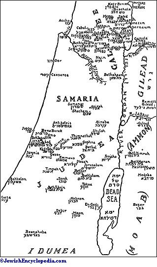
Most of the hot springs have been mentioned above: those of Tiberias (58-63° C.), those in thevalley of the Yarmuḳ (25-48° C.), and those of Callirrhoe, in the Wadi Zarḳa Ma'in (62.8° C.). There are also some hot springs where this river empties into the Dead Sea. Numerous other springs with lukewarm water seem to be thermæ that are gradually losing their heat. As all these springs are in the vicinity of the great rift of the Jordan, their origin must be connected with that of the rift.
Climate.
Climatically, Palestine is divided into three zones: the subtropical zone of the coast, the continental mountain district, and the tropical Jordan valley. In general there are only two seasons, the summer season, dry and hot, and the winter season, cool and rainy. They follow each other abruptly, the European and American spring being represented only by a few weeks following the close of the rainy season. Rain is rare as late as the second half of May, and no rain whatever falls between June and September. The rainy season sets in at the end of October, or, more frequently, in November. It begins with the "first rain" of the Old Testament (Deut. xi. 14 et al.), which loosens the dry earth for plowing. Then, after a period of mild weather, the heavy winter rains set in, toward the middle of December, soaking into the ground and filling the wells and cisterns. They are heaviest in January. The "latter rain," in March and April, promotes the growth of the grain. The crops depend not only on the quantity but also on the proper distribution of rain. The most profuse latter rain will not compensate for a lack of the early and the winter rains; and, conversely, the latter rain is necessary, even after abundant winter rains, to enable the growing crops to withstand the warm days of the early summer. The mean duration of the entire rainy season for Jerusalem is 192 days (the longest, 217; the shortest, 126); the mean rainfall is 581.9 millimeters during 52.4 days of rain. The vegetation withers early in the summer, since the dry season coincides with the hot, although the ill effects are somewhat modified by the heavy dews caused by the moist sea-winds. Snow frequently falls in Jerusalem during the winter, though it melts quickly, and occasionally there is hail. At Jerusalem the mean temperature is 17.2° C.; the highest temperature recorded is 44.4°, and the lowest—4°. Between the months of March and May the thermometer rises quickly from 11.8° to 20°, falling as rapidly to 11° between October and December. The great variations in a single day are characteristic, amounting on the average to 12.95° in the summer and 8.7° in the winter. The changes in the east-Jordan country are greater still.
Winds.
The principal winds are the trade-wind and the antitrade-wind. The former blows in the Mediterranean countries in the summer, from a northerly and northwesterly direction, and as it comes from cooler latitudes it is a dry wind; hence Jerusalem is swept between May and October for the most part by dry, cool winds coming from the north and northwest. In the winter the antitradewinds prevail in the region of the Mediterranean, bringing rain; so that Jerusalem gets its rain-winds from the southwest and west. The regular alternation between sea-winds and land-winds is another important factor. During the day the calcareous mountains get heated much more quickly than the sea, so that the cooler lower strata of the air are blown toward the land, where the hot air rises. The reverse takes place at night, and the entire process is repeated on a larger scale in the summer and winter. Thus in the summer a light sea-wind rises every morning about nine or ten o'clock, reaches Jerusalem about noon, and blows until after sunset, when the cooler land-wind sets in. This daily sea-wind is highly important for men, beasts, and plants. At Jerusalem the cool north and northwest winds blow on an average during 114 days, and the west winds, which bring rain, blow during 55 days. The less frequent south wind is warmer. The east wind is dry; while it is welcomed in the winter, it is dreaded in the summer on account of its heat and parching effect. The southeast wind, the sirocco, which often blows for several days in succession, especially in May and October, is destructive. At such times there is an oppressive sultriness; the air is filled with fine dust, drying up the mucous membrane of the bronchial tubes and causing lassitude, headache, and even fever. If it sweeps through fields of growing grain in the spring it often withers them completely (comp. Jer. xviii. 17; Ezek. xxvii. 26; Job i. 19, xv. 2).
The climate of the coastal plain is warmer, the mean temperature being 20.5° C., but this region also gets more of the fresh sea-wind, and the number of rainy days as well as the quantity of rain is also larger, while less rain falls in the Jordan valley and no snow falls at Jericho. The mean temperature is estimated theoretically at about 24° on the northern shore of the Dead Sea, which nearly corresponds to the tropical heat of Nubia. In the Jordan valley the harvest begins between three and four weeks earlier than in the mountains, but there are no reliable records for any length of time for that district.
It is frequently asserted that the climate has changed within the historic period, and as the fertility of the country in former times is often mentioned, more favorable natural conditions must be assumed to have existed. All the references of the Old Testament, however, which bear on this question apply exactly to modern climatic conditions, and even if there were then more forests than at present, as is frequently asserted, this could not have been the case to an extent great enough materially to influence the climate.
Flora.
On account of the diversity of its topographic and climatic conditions Palestine is rich in the variety of its flora. Three plant-zones may be distinguished. (1) The vegetation of the coast region and the west-Jordan mountain district is most closely related to that of Italy, Sicily, Greece, Algeria, etc., the so-called flora of the Mediterranean. It is characterized by a number of evergreen shrubs, and of vernal herbaceous plants which wither quickly. There are also orange-, lemon-, olive-, and pine-trees, oleanders, myrtles, anemones, hyacinths, and tulips. (2) The subtropical flora of the Jordan valley recalls that of Abyssinia and Nubia. Peculiar to the Jordan valley are the 'oshr (Calotropis procera), bearing thetrue apple of Sodom; the false apple of Sodom (Solanum sanctum); the seyal acacia (Acacia Seyal; abounding also on Sinai), from which gum arabic is obtained; the zachun (oil-tree; Balanites Ægyptiaca), a thorny shrub with edible berries; the rose of Jericho (Anastatica Hierochuntina), which no longer grows in Jericho, but only at Masada; and the sidr- and nubk-trees (Zizyphus lotus and Zizyphus Spina-Christi) with their great thorns. The true African papyrus (Papyrus antiquorum) is also found at Lake Tiberias and Lake Ḥulah. (3) The Oriental steppe and desert vegetation is found especially in the Negeb and along the frontier of the cultivated region in the east-Jordan country, as well as on the eastern slopes of the west-Jordan district. Characteristic of this flora are the comparative lack of trees, the preponderance of small, thorny shrubs (Poterium), the wealth of species of astragalus (small, thorny plants), and of peculiar species of the thistle (Cousinia) in the summer, as well as of the quickly fading, brilliant little spring plants. On the fruit-trees, which are found in small groves at nearly every village, see Fig and Fig-Tree; Horticulture; Olive. Real forests are seen only in the east-Jordan country; the forest-trees, which are found but seldom and then in small groves in the west-Jordan district (at Mount Carmel and at Tabor in Upper Galilee), include several species of oak, the terebinth (Pistacia Terebinthus; Arabic, "buṭun"), and more rarely the cypress (Cupressus sempervirens), the Aleppo pine (Pinus Halepensis), and the wild St.-John's-bread-tree (Ceratonia Siliqua; Arabic, "kharrub"). Most of these species occur merely as bushes, since the goats which pasture in these "forests" do not allow the trees to attain full size. On the field and garden plants see Horticulture.
Fauna.
The fauna is no less varied; there is scarcely any other region of equal size in which so many different kinds of mammals may be found as here. Northern Palestine, together with Syria, belongs to the Palearctic region, while southern Palestine forms part of the Ethiopian region (Sinai, Egypt, Nubia). The approximate boundary-line runs from the southern edge of Carmel to the southern shore of the Lake of Tiberias. As some species overlap from one region to the other, there is a narrow, mixed district, while in both there are importations from the Indo-Mesopotamian zone. Representative of the Palearctic region are the deer, buck, snow-mouse, field-mouse, marmot, dormouse, polecat, ermine, stone-marten, badger, bear, and others; while characteristic of the Ethiopian fauna are the African mouse, jerboa, running mouse, fat sand-mouse (Psammonis obesus), and Eliomys melanurus; among the hares the Lepus sinaiticus and Lepus œgypticus; the rock-badger (Hyrax syriacus), a species of ibex (Capra beden), the gazel (Gazella dorcas), the desert-cat (Felis manicalata), the leopard (Felis pardus), the Nile fox (Vulpes niloticus), and the ichneumon (Herpestes ichneumon). The Indian fauna is thought to be represented by a species of field-rat, and the wolf, jackal, and hyena of Palestine are also supposed to be related to the Indian fauna. On the domestic animals see Ass; Cattle; Dog; Horse; Mule; etc.
Most of the birds belong, probably, to the Palearctic region, although there are many species of the Ethiopian and a few of the Indian region. The ornithological wealth of Palestine may be due to the fact that many migratory birds pass over the country in their flight. Among the reptiles 33 species of snakes and 44 of lizards are enumerated by Tristram. The African crocodile is found in the swamps of the Crocodile River, as already noted, and one was killed as late as 1901. The Lake of Tiberias and the Jordan abound in fish, of which Tristram enumerates 43 species; in the former, curiously enough, some exist that otherwise are found only in the Nile (Chronus niloticus and Cerrias macrocanthus). There is a superabundance of insects: flies, gnats, fleas, spiders, scorpions, etc., and more than 40 species of locusts. See Insects.
Political Geography.
The names given to Palestine by the Egyptians and Assyrians have already been enumerated, but a number of additional place-names are found in the Egyptian lists of Thothmes III., Rameses II., Shoshenḳ (the Shishak of the Bible), and Sethos I., including those of Megiddo and Taanach, Sharon, Beeroth, Ashtaroth, Joppa, Lod, Ono, Soco, Negeb, and many others. The boundaries of the Israelitic settlement have been mentioned above, as well as the division of the country in the Israelitic time and the names of the different divisions. The extent of the Jewish territory immediately after the return from the Exile was a very limited one. Its detailed discussion belongs to the history and not to the geography of the country, and the same statement holds true regarding the history of the enlargement of its boundaries under the Hasmoneans.
At the beginning of the present era Palestine was divided into the following districts: (1) Judea (with Idumea); (2) Samaria, extending from the southern boundary of Judea to the southern edge of the plain of Esdraelon; (3) Galilee, including the plain of Esdraelon; (4) Perea, the east-Jordan country, to the district of Jarash (Gerasa) and 'Amman (Philadelphia) in the east, and from the Wadi al-Mujib (Arnon) in the south to Khirbat Fahil (Pella) in the north; (5) the districts of the tetrarchy of Philip, comprising Gaulanitis (Jaulan), Batanea (Al-Nuḳrah), Trachonitis (Al-Lajah), and Auranitis (the mountains of the Ḥauran). The Hellenistic cities in the east-Jordan district (Damascus, Gerasa, Philadelphia, and others), together with Scythopolis (Baisan), were combined under the name of Decapoils. See Galilee; Samaria.
After the revolt of 66-70 the country became the Roman province of Judea under a pretorian prefect; and Hadrian gave it the name of Syria Palæstina after the insurrection of 132-135, when it was placed under a consular legate. The boundaries of this district varied, especially the line separating it from the province of Arabia, which had been formed by Trajan from the country of the Nabatæans. Septimius Severus (193-211) or Diocletian (285-305) incorporated Philadelphia, Gerasa, and other cities of the east-Jordan district with Arabia; but for a time Petra was united with Palestine, until it became, in 358, a separate province under the name of Palæstina Salutaris, including the Negeb and the country south of the Dead Sea. In the fifth century there were the following provinces: (1) Palæstina Prima (capital Cæsarea) = Judea and inland Samaria; (2) Palæstina Secunda (capital Scythopolis) = Judea and Perea; (3) Palæstina Tertia, or Salutaris (capital Petra) = the Negeb and the east-Jordan country south of the Arnon; (4) Phenicia Maritima (capital Tyre) = the coast region; (5) Phenicia ad Libanum (capital Emesa) = Cœle-Syria and the region of the Lebanon, together with Damascus and Palmyra; (6) Arabia (capital Bostra), the region of the Ḥauran, in the south.
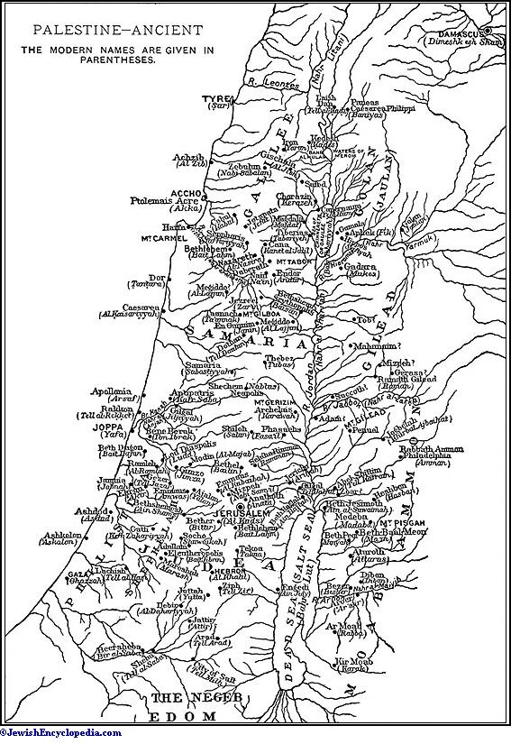
Present Divisions.
In 636 the calif Omar divided Syria into five military districts, of which Filisṭin included the west-Jordan country as far as the plain of Esdraelon; Al-Urdunn (the Jordan) included Galilee and the Jordan valley; and the district of Damascus included the east-Jordan country. The discussion of the formation of small principalities under Turkish rule belongs to history. The country is now divided into the following administrative districts: (1) the vilayet of Beirut, comprising the territory between the sea and the Jordan, extending about as far south as Jaffa, and including the districts of Nablus and Acre; (2) the independent district of Jerusalem, directly under the Ottoman government, and including the remaining portion of the west-Jordan country; (3) the vilayet of Damascus, embracing the entire east-Jordan country and including the district of the Ḥauran (capital Shaikh Sa'd), which extends to the Nahr al-Zarḳa, and the district of Ma'an (capital Al-Karak). For the Medeba mosaic see Medeba.
Bibliography:
A bibliography from the fourth century to 1877 is given by R. Röhricht, Bibliotheca Geographica Palœstinœ, 1890, and for the following years in the annual bibliographies of the Z. D. P. V. (1878 to 1896) and the Rev. Bib. (1892 et seq.).
Periodicals dealing with Palestine: Pal. Explor. Fund, Quarterly Statement, 1865 et seq.;
Z. D. P. V. 1877 et seq.;
Rev. Bib. 1892 et seq.
Works upon Palestine (only the most important of which are noted here): H. Reland, Palœstina ex Monumentis Veteribus Illustrata, Utrecht, 1714;
Robinson, Researches, 3 vols., 1841;
idem, Later Researches, 1852;
idem. Physical Geography of the Holy Land, 1865;
Ritter, Erdkunde, 2d ed., vols. xiv.-xvii. (Sinaitic Peninsula, Palestine, and Syria), 1848-55;
Neubauer, Géographie du Talmud, 1868;
Victor Guérin, Déscription de la Palestine: I., Judée 3 vols., Paris, 1868-69;
Samarie, 2 vols., 1874-75;
Galilée, 2 vols., 1880;
The Survey of Western, Palestine, Memoirs of the Topography, etc., 3 vols., 1881-83;
Arabic and English Name Lists, 1881;
Trelawney Saunders, An Introduction to the Survey of Western Palestine, Its Waterways, Plains, and Highlands, 1881;
Thomson, The Land and the Book, 3 vols., 1881-86;
M. Lortet, La Syrie d'Aujourd'hui, 1884;
G. Ebers and H. Guthe, Palästina in Bild und Wort, 2 vols., 1883-84;
O. Ankel, Grundzüge, der Landesnatur des Westjordanlandes, 1887;
G. A. Smith, Historical Geography of the Holy Land, 1891;
Guy le Strange, Palestine Under the Moslems, 1890;
M. Blankenhorn, Die Strukturlinien Syriens und des Roten Meeres, 1893.
Works on single districts: W. F. Lynch, Narrative of the U. S. Expedition to the River Jordan and the Dead Sea, 1849;
F. de Sauley, Voyage Autour de la Mer Morte, etc., 1853;
A. Duc de Luynes, Voyage d'Exploration à la Mer Morte, à Petra et sur la Rive Gauche du Jourdain, 3 vols., 1871-76;
I. G. Wetzstein, Reisebericht über den Hauran und die Trachonea, 1860;
G. Schumacher, Der Dsholan, 1886;
idem, Across the Jordan, 1886;
idem, Northern 'Ajlûn, 1890;
idem, Das Südliche Basan, 1897;
Tristram, The Land of Moab, 1874;
The Survey of Eastern Palestine (Pal. Explor. Fund), 1889.
Works on geology, botany, zoology, climate: O. Fraas, Aus dem Orient, 2 vols., 1867-78;
C. Diener, Libanon, 1886;
Ed. Hall, Memoir on the Physical Geology and Geography of Arabia Petrœa, Palestine, and Adjoining Districts (part of the Survey of Western Palestine);
Celsius, Hierobotanicon, 2 vols., 1845-47;
Edm. Boissier, Flora Orientalis, 5 vols. and Supplement, 1867-88;
I. Löw, Aramäische Pflanzennamen, 1881;
Leo Anderlind, Die Fruchtbäume in Syrien, in Z. D. P. V. 1888;
G. E. Post, Flora of Syria, Palestine, and Sinai, 1896;
H. B. Tristram, Natural History of the Bible, 3d ed., 1889;
idem, The Fauna and Flora of Palestine, 1884 (part of the Survey of Western Palestine);
H. Chichester Hart, Some Account of the Fauna and Flora of Sinai, Petra, and Wady Araba, 1891 (part of the Survey of Western Palestine);
S. Bochart, Hierozoicon, 3 vols., 1792-96;
L. Lewysohn, Zoologie des Talmuds, 1858;
J. G. Wood, Bible Animals, 1883.
Maps: Map of Western Palestine, in 26 sheets, scale 1 inch (Pal. Explor. Fund, 1880; also reduced to ⅜-inch scale, 1881). Partial maps of the country east of the Jordan are contained in Survey of Eastern Palestine and in the works of Schumacher.
Fruit Produce.
—Modern Commerce:
West of the Jordan, around Jaffa, the main products of Palestine are grapes and oranges, and, in the vicinity of Safed, olives and olive-oil. Grain is produced principally in the south, Gaza being the center of the barley country, and in the Ḥauran district, east of the Jordan, which is the center of the wheat-producing territory. Grain production is still in the hands of the native Arabs with their ancient mode of cultivation and lack of proper milling facilities. Consequently, though Ḥauran wheat is considered among the best in the world, it does not make fine flour, which must be imported from Russia and America. "Durrah," a kind of maize, and "ḥimmiṣ," a species of pea, are easy to cultivate and are largely exported. Palestinian olives and olive-oil are equal, if not superior, to the Italian products, but the growers lack facilities for purifying the oil and extracting its "bitterness." Sesame ( ), which produces a sweet-oil, is much appreciated by the natives, and is exported in large quantities to France. Cucumbers, tomatoes, and watermelons are exported to Egypt. The largest item of export is oranges from the groves at Jaffa. From Oct., 1898, to April, 1899, 338,000 boxes (containing about 50,000,000 oranges) were exported, of which England received 278,000 boxes. The average price in that year was $1.25 per box of 100 to 160 oranges. The orange export trade developed immediately upon the establishment of direct connection with Liverpool in 1892.
Wines and Cognac.
The center of viticulture was Hebron, where the oldest and best wines are still found; but since the Jewish colonies were established the center of that industry has been removed to Rishon le-ẓiyyon, near Jaffa, where the Rothschild wine-presses are located. The export of wines and cognac is chiefly from the Rothschild vineyards. The Palestinian wine received the gold medal at the Paris Exposition of 1900. The high quality of the wine (mostly "Sauterne," "Malaga," and "Muscatel") and cognac from Palestine is evidenced by their increasing exportation, in the last few years, to various parts of the world.
The colocynth-plant (in Arabic, the "ḥanṭal") is a bitter apple, and its dried pulp is used as a purgative, also in the brewing of beer and for other purposes. The colocynth grows wild and abundantly on the plains between the mountains and the shore of the Mediterranean. The plant is sold in Gaza and Jaffa, where it is peeled, the pulp being dried in the sun and then closely packed in boxes for shipment, generally to England. Theaverage annual export from Jaffa is 10,000 pounds; the price being about 30 cents per pound, on board, at Jaffa. The trade in honey has been developed by the Baldenberger family since 1880, at Ramlah, near Jaffa, where the bees have the benefit of the orange- and lemon-trees and of the wild thyme. Good markets are found in Germany, Switzerland, and England for all the honey produced.
Wool, Silk, and Soap.
Apart from the agricultural products, Palestine is suited for raising cattle and sheep, though the export of animals is now prohibited by the Turkish government. The principal grazing-places are near Hebron, Nablus, and Gaza, and in the Moabite countries across the Jordan. The sheep are all of the Barbary, broad-tailed variety. The fleece averages about five pounds per head, and is valued, unwashed, at about eight cents per pound. In 1900 the export from Jaffa reached 166,000 kilos (365,000 pounds) of wool. Very little of the wool is utilized for domestic purposes, as nearly all the weaving in Palestine is done on hand-looms. Waterproof cloaks called "'abayah" are made for the peasants' wear; the garment has black-striped borders and resembles the ṭallit. The Jewish Colonization Association has established a weaving-factory at Jerusalem, and in 1901 introduced a process of dyeing.
The silk produced in northern Palestine (Syria) exceeds 5,000,000 pounds and is exported via Beirut. A factory has been established at Rosh Pinah colony (near Safed) for the manufacture of silk floss, and there are several looms for silk ribbon. The factory buys the cocoons at about 30 cents each from the colonists in the neighborhood. The silk is shipped to Marseilles and Lyons.
Another article of export is soap, made chiefly at Nablus. Mrs. Finn, representing an English society, introduced into Jerusalem the manufacture of soap from olive-oil by the Yemenite Jews. The product is exported to England. The manufacture of sacred mementos from mother-of-pearl and bituminous limestone is conducted by Christian Arabs at Beth-lehem. But the carving of olive-wood and the pressing of flowers upon cards in the bazaars of Jerusalem are nearly all done by Jews. Most of the mementos of a Christian character are exported to England and America. In 1902 this export amounted to nearly $20,000. Beirut is next to Jaffa in importance as a seaport. One firm at Beirut is exporting to the United States over $1,000,000 worth of merchandise annually, mostly olive-oil and licorice-root. The Turkish duty on exports is 1 per cent and on all imports 8 per cent.
The principal hindrance to the development of Palestinian commerce comes from the Turkish government, in local taxation, the indirect exactions of the Turkish officials and neighboring sheiks, and the irades against all electrical appliances. Another drawback is the want of railways, the Jaffa-Jerusalem and Beirut-Damascus-Ḥamah-Muzerib railways being the only lines in operation.
Principal Articles of Import and Export at Jaffa During 1898-1902, as Reported by the British Consul.
|
Imports. |
1898. |
1899. |
1900. |
1901. |
1902. |
|
|
£ |
£ |
£ |
£ |
£ |
|
Wheat |
...... |
...... |
...... |
...... |
15,300 |
|
Cotton Goods |
56,600 |
61,500 |
115,050 |
100,600 |
112,900 |
|
Coffee |
18,000 |
51,200 |
30,080 |
18,350 |
9,250 |
|
Rice |
35,500 |
32,500 |
36,440 |
45,400 |
38,200 |
|
Sugar |
41,600 |
33,000 |
28,890 |
26,800 |
19,200 |
|
Petroleum |
8,500 |
16,500 |
17,700 |
20,550 |
13,800 |
|
Hardware |
4,050 |
5,850 |
7,950 |
10,600 |
7,180 |
|
Fancy Goods |
12,150 |
14,875 |
5,680 |
2,050 |
2,210 |
|
Cloth |
18,920 |
22,400 |
19,500 |
6,850 |
2,050 |
|
Wines and Cognac |
2,500 |
3,375 |
5,820 |
3,350 |
3,550 |
|
Coal |
8,160 |
8,860 |
5,800 |
7,980 |
6,850 |
|
Timber |
15,300 |
18,450 |
14,130 |
16,750 |
16,150 |
|
Tiles |
4,600 |
5,150 |
4,865 |
3,930 |
...... |
|
Salt |
2,600 |
2,500 |
3,500 |
7,050 |
5,220 |
|
Flour |
15,000 |
30,000 |
22,700 |
53,500 |
62,500 |
|
Iron |
30,450 |
31,600 |
17,925 |
11,800 |
3,650 |
|
Tobacco |
...... |
...... |
...... |
...... |
42,800 |
|
Oil-Engines |
...... |
...... |
...... |
4,700 |
8,050 |
|
Other Articles |
48,500 |
52,500 |
46,375 |
86,050 |
36,690 |
|
|
______ |
______ |
_______ |
___________ |
________ |
|
|
Totals |
322,430 |
390,260 |
382,405 |
426,310 |
405,550 |
|
|
1898. |
1899. |
1900. |
1901. |
1902. |
|
|
£ |
£ |
£ |
£ |
£ |
|
Wheat |
14,000 |
...... |
...... |
...... |
...... |
|
Maize |
3,000 |
1,225 |
2,950 |
120 |
1,440 |
|
Olive-Oil |
4,500 |
1,350 |
9,110 |
1,500 |
...... |
|
Sesame |
28,000 |
21,000 |
30,560 |
25,200 |
29,260 |
|
Soap |
62,000 |
125,750 |
44,550 |
57,000 |
18,760 |
|
Wool |
3,360 |
1,750 |
1,360 |
2,150 |
1,320 |
|
Oranges |
82,500 |
77,000 |
74,215 |
86,525 |
86,500 |
|
Colocynth |
1,400 |
1,300 |
1,880 |
2,190 |
1,450 |
|
Hides |
8,100 |
10,250 |
1,615 |
3,450 |
2,990 |
|
Beans |
1,800 |
...... |
575 |
220 |
...... |
|
Lupins |
18,600 |
10,000 |
12,900 |
6,680 |
...... |
|
Bones |
420 |
725 |
200 |
850 |
...... |
|
Wines and Cognac |
20,500 |
2,900 |
21,840 |
35,350 |
18,400 |
|
Watermelons |
24,850 |
26,100 |
24,500 |
21,750 |
17,650 |
|
Mementos |
...... |
...... |
...... |
...... |
4,850 |
|
Other Articles |
33,750 |
36,800 |
38,695 |
34,650 |
20,770 |
|
|
______ |
______ |
_______ |
________ |
_______ |
|
|
Totals |
306,780 |
316,150 |
264,950 |
277,635 |
203,390 |
Total Imports and Exports at Jaffa During 1900-2, According to Countries.
|
Countries. |
Imports. |
Exports. |
||||
|
_______________________ |
______________________ |
|||||
|
1900. |
1901. |
1902. |
1900. |
1901. |
1902. |
|
|
|
£ |
£ |
£ |
£ |
£ |
£ |
|
Great Britain |
38,000 |
40,000 |
65,000 |
77,000 |
74,500 |
70,000 |
|
Turkey |
59,500 |
64,500 |
120,000 |
31,500 |
25,700 |
22,000 |
|
France |
70,000 |
60,800 |
50,000 |
50,300 |
41,000 |
28,000 |
|
Italy |
21,500 |
14,000 |
13,000 |
7,200 |
10,000 |
8,000 |
|
Egypt |
60,800 |
50,700 |
31,000 |
61,400 |
55,000 |
32,000 |
|
Russia |
42,000 |
45,000 |
30,000 |
10,000 |
8,000 |
6,000 |
|
Germany |
41,300 |
30,000 |
21,000 |
13,400 |
17,500 |
15,000 |
|
Austria-Hungary |
...... |
32,600 |
45,000 |
...... |
12,000 |
10,000 |
|
Belgium |
...... |
...... |
18,000 |
...... |
...... |
2,000 |
|
America |
3,000 |
4,000 |
3,500 |
2,000 |
3,500 |
4,000 |
|
Cyprus |
4,000 |
...... |
...... |
...... |
...... |
...... |
|
Other Countries |
42,305 |
84,710 |
9,050 |
12,150 |
30,435 |
6,390 |
|
|
|
_______ |
_______ |
_______ |
_______ |
_______ |
_______ |
|
|
Totals |
382,405 |
426,310 |
405,550 |
264,950 |
277,635 |
203,390 |
Palestine is rich in minerals, as of old (Deut. viii. 9). There are asphalt-mines in the vicinity of Ḥasbaya, salt deposits in the Dead Sea, and phosphate deposits on either side of the Jordan. There are opportunities also for the cultivation of the sugarcane near Jericho, in the valley of the Jordan, where there are still found some ruins of ancient sugar-mills and where the soil is well suited for this purpose. The same soil may be cultivated for cottonand tobacco. Lately, experiments have been made by the Jewish colonists in planting tobacco, in which they have met with some success. See Agricultural Colonies in Palestine; Agriculture.
Bibliography:
British Diplomatic and Consular Reports, Annual Series, Nos. 2217, 2405, 2584, 2822;
United States Consular Reports: Commerce and Industry, xxxiv. 683;
Sheep and Wool, xxxv. 594;
Fuel, xxxviii. 338;
Poultry Industry, xliii. 576;
Colocynth Plant, xlvii. 545;
United States Products, lix. 16;
John Dickson, Report, in Luaḥ Ereẓ Yisrael, 1903, ix. 166-179;
Eisenstein, Products and Industries of Palestine, and Commerce Between the United States and Palestine, in The Maccabean, 1901, i. 1, 2;
Zangwill, The Commercial Future of Paletstine, in English Illustrated Magazine, 1902, xxvi. 352-360, 421-430;
Nossig and Trietsch, Palästina, vol. i., Berlin, 1902.
PALESTINE
1. Situation and name.—The land of Palestine is the territory which lies between the Mediterranean Sea and the Arabian Desert as E. and W. boundaries, and whose N. and S. boundaries may be approximately stated at 31° and 33° 20’ N. Lat. respectively. These boundaries have not always been clearly fixed; but the convention is generally agreed upon that Palestine is separated from Egypt by the Wady el-’Arîsh or ‘River of Egypt,’ and from Syria by the Kasmiyeh or Lîtani River, the classical Leontes. Biblical writers fixed the limits of the territory by the towns Dan and Beersheba, which are constantly coupled when the author desires to express in a picturesque manner that a certain event affected the whole of the Israelite country (e.g. Jdg 20:1). The name ‘Palestine’ [AV
2. Geology and geography.—The greater part of the country is of a chalky limestone formation, which overlies a layer of red sandstone that appears on the E. shore of the Dead Sea and elsewhere. Under the red sandstone are the archæan granitic rocks which form a large part of the Sinai Peninsula. Above the chalk is a layer of nummulitic limestone, which appears on some mountains. Volcanic rock, the result of ancient eruptions, appears in the Hauran, Galilee (especially in the neighbourhood of Safed), and elsewhere. For fuller information on the geology of the country, see art. Geology. With respect to the surface, Palestine divides naturally into a series of narrow strips of country running from north to south, and differing materially from one another in character. (a) The first of these is the Maritime Plain running along the coast of the Mediterranean from the neighbourhood of Sidon and Tyre southward, and disappearing only at the promontory of Carmel. This plain widens southward from Carmel to a maximum breadth of about 20 miles, while to the north of that promontory it develops into the great plain of Esdraelon, which intersects the mountain region and affords the most easy passage into the heart of the country. This plain is covered with a most fertile alluvial soil. (b) The second strip is the mountainous ridge of Judæa and Samaria, on the summit of which are Hebron, Jerusalem, and other important towns and villages; and which, with the single interruption of the piain of Esdraelon, runs continuously from the south border of the country to join the system of the Lebanon. (c) The third strip is the deep depression known as the Ghôr, down which runs the Jordan with its lakes. (d) The fourth strip is the great plateau of Bashan, Moab, and Edom, with a lofty and precipitous face towards the west, and running eastward till it is lost in the desert.
3. Water supply, climats, natural products.—There is no conspicuous river in Palestine except the Jordan and its eastern tributaries, and these, being for the greater part of their course in a deep hollow, are of little or no service for irrigation. In consequence, Palestine is dependent as a whole for its water supply on springs, or on artificial means of storage of its winter rains. Countless examples of both exist, the former especially in Galilee, parts of which are abundantly fertile by nature, and would probably repay beyond all expectation a judicious expenditure of capital. The case of Judæa is a little different, for here there are extensive tracts which are nearly or quite waterless, and are more or less desert in consequence.
The climate of Palestine is, on the whole, that of the sub-tropical zone, though, owing to the extraordinary variation of altitudes, there is probably a greater range of average local temperature than in any other region of its size on the world’s surface. On the one hand, the summits of Hermon and of certain peaks of the Lebanon are covered with snow for the greater part of the year; on the other hand, the tremendous depression, in the bottom of which lies the Dead Sea, is practically tropical, both in climate and in vegetation. The mean local temperature is said to range from about 62° F. in the upland district to almost 100° F. in the region of Jericho.
Rainfall is confined to the winter months of the year. Usually in the end of October or November the rainy season is ushered in with a heavy thunderstorm, which softens the hard-baked surface of the land. This part of the rainy season is the ‘former rain’ of the Bible (as in Joe 2:23). Ploughing commences immediately after the rains have thus begun. The following months have heavy showers, alternating with days of beautiful sunshine, till March or April, when the ‘latter rain’ falls and gives the crops their final fertilization before the commencement of the dry season. During this part of the year, except by the rarest exception, no rain falls: its place is supplied by night dews, which in some years are extraordinarily heavy. Scantiness of the rainfall, however, is invariably succeeded by poverty or even destruction of the crops, and the rain is watched for as anxiously now as it was in the time of Ahab.
Soon after the cessation of the rains, the wild flowers, which in early spring decorate Palestine like a carpet, become rapidly burnt up, and the country assumes an appearance of barrenness that gives no true idea of its actual fertility. The dry summer is rendered further unpleasant by hot east winds, blowing from over the Arabian Desert, which have a depressing and enervating effect. The south wind is also dry, and the west wind damp (cf. 1Ki 18:45, Luk 12:54). The north wind, which blows from over the Lebanon snows, is always cold, often piercingly so.
As already hinted, the flora displays an extraordinary range and richness, owing to the great varieties of the climate at different points. The plants of the S. and of the Jordan Valley resemble those found in Abyssinia or in Nubia: those of the upper levels of Lebanon are of the kinds peculiar to snow-clad regions. Wheat, barley, millet, maize, peas, beans, lentils, olives, figs, mulberries, vines, and other fruit; cotton, nuts of various species; the ordinary vegetables, and some (such as solanum or ‘egg-plant’) that do not, as a rule, find their way to western markets; sesame, and tobacco—which is grown in some districts—are the most characteristic crops produced by the country. The prickly pear and the orange, though of comparatively recent introduction, are now among its staple products. The fauna includes (among wild animals) the bat, hyæna, wolf, jackal, wild cat, ibex, gazelle, wild boar, hare, and other smaller animals. The bear is now confined to Hermon, and possibly one or two places in Lebanon; the cheetah is rare, and the lion (1Sa 17:34, 1Ki 13:24 etc.) is extinct. So also is the hippopotamus, bones of which have been found in excavations. Among wild birds we may mention the eagle, vulture, stork, and partridge: there is a great variety of smaller birds. Snakes and lizards abouod, and crocodiles are occasionally to be seen in the Nahr ez-Zerka near Cæsarea. The domesticated animals are the camel, cow, buffalo (only in the Jordan Valley), sheep, horse, donkey, swine (only among Christians), and domestic fowl. The dog can scarcely be called domesticated: it is kept by shepherds for their flocks, but otherwise prowls about the streets of towns and villages seeking a living among the rubbish thrown from the houses.
4. History, races, antiquities.—The earliest dawn of history in Palestine has left no trace in the country itself, so far as we can tell from the limited range of excavations hitherto carried out. There was, however, a Babylonian supremacy over the country in the fourth millennium b.c., of which the records left by the kings of Agade speak. These records are as yet only imperfectly known, and their discussion in a short article like the present would be out of place. A very full account of all that is as yet known of these remote waifs of history will be found in L. B. Paton’s excellent History of Syria and Palestine.
About b.c. 3000 we first reach a period where excavation in Palestine has some information to give. It appears that the inhabitants were then still in the neolithic stage of culture, dwelling in caves, natural or artificial. The excavation of Gezer has shown that the site of that city was occupied by an extensive community of this race. They were non-Semitic; but as they practised cremation, the bones were too much destroyed to make it possible to assign them to their proper place among the Mediterranean races. Further discoveries may ultimately lead to this question being settled. It is possible that the Horites of Gen 14:6 and elsewhere may have been the survivors of this race.
About b.c. 2500 the first Semitic settlers seem to have established themselves in the country. These were the people known to Bible students as Canaanites or Amorites. The success of attempts that have been made to distinguish these names, as indicating two separate stocks must be considered doubtful, and it is perhaps safer to treat the two names as synonymous. About b.c. 2000, as appears by the reference to ‘Amraphel, king of Shinar’ (= Hammurabi), occurred the battle of the four kings and five recorded in Gen 14:1-24—the first event on Palestinian soil of which a Palestinian record is preserved.
The dominion of Egypt over S. Palestine, or at least the influence of Egyptian civilization, must early have been felt, though no definite records of Egyptian conquest older than Tabutmes iii. (about b.c 1500) have come to light. But scarabs and other objects referable to the Usertesens (about b.c. 2800–2500, according to the opinions of various chronologists) are not infrequently found in excavations, which speak of close intercourse between the Canaanites and the civilization of the Nile valley. Of the Canaanites very extensive remains yet await the spade of the excavator in the mounds that cover the remains of the ancient cities of Palestine. The modern peasantry of the country closely resemble the ancient Canaanites in physical character, to judge from the remains of the latter that excavation has revealed; indeed, in all probability the substratum of the population has remained unchanged in racial affinities throughout the vicissitudes that the country has suffered. By the conquests of Tahutmes iii. (c. 1500), and Amenhotep iii. (c. 1450), Palestine became virtually an Egyptian province, its urban communities governed by kings (i.e. local sheiks) answerable to the Pharaoh, but always quarrelling among themselves. The ‘heretic king’ Amenhotep iv. was too busy with his religious innovations to pay attention to his foreign possessions, and, city by city, his rule in Palestine crumbled away before the Aramæan tribes, named in the Tell el-Amarna tablets the Khabiri. This name is identical with that of the Biblical Hebrews; but it has not yet been possible to put the Khabiri and the Hebrews into their proper mutual relations. The Hebrews represent themselves as escaped slaves from Egypt who (about the 13th cent. b.c.) were led as a solid whole under a single leader (Joshua) to the complete conquest of Canaan—this is the account of the Book of Joshua. According to the older tradition preserved in Jdg 1:1-36, they entered the country without an individual leader, as a number of more or less independent tribes or clans, and effected only a partial conquest, being baffled by the superior strength of certain specified cities. This account is more in accordance with the events as related by the Tell el-Amarna tablets, but further discoveries must be made before the very obscure history of the Israelite immigration can be clearly made out.
The Israelite occupation was only partial. The important Maritime Plain was in the hands of a totally distinct people, the Philistines. The favourite, and most probable, modern theory regarding the Philistines is that they were of Cretan origin; but everything respecting that mysterious race is veiled in obscurity. As above mentioned, it is not likely that the change of ownership affected the peasants—the Gibeonites were probably not the only ‘hewers of wood and drawers of water’ (Jos 9:21) that survived of the older stock. And lastly, we cannot doubt that an extensive Canaanite occupation remained in the towns expressly mentioned in Jdg 1:1-36, as those from which the various tribes ‘drave not out’ their original inhabitants. So far as we can infer from excavation—an inference thoroughly confirmed by a consideration of the barbarous history of the Judges—the effect of the Israelite entrance into Canaan was a retrogression in civilization, from which the country took centuries to recover.
The history of the development of these incoherent units into a kingdom is one of ever-fresh interest. It is recorded for us in the Books of Judges and 1Samuel, and the course of events being known to every reader, it is unnecessary to recapitulate them here. It is not unimportant to notice that the split of the short-lived single kingdom into two, after the death of Solomon, was a rupture that had been foreshadowed from time to time—as in the brief reign of Abimelech over the northern province (Jdg 9:1-57), and the attempt of the northerners to set up Ish-bosheth as king against David (2Sa 2:3), frustrated by Ish-bosheth’s ill-timed insult to Abner (2Sa 3:7): Abner’s answer (v. 10) recognizes the dichotomy of Judah and Israel as already existing. This division must have had its roots in the original peopling of the country by the Hebrews, when the children of Judah went southward, and the children of Joseph northward (Jdg 1:3-28).
Space will not permit us to trace at length the fortunes of the rival kingdoms, to their highest glory under the contemporary kings Uzziah and Jeroboarn ii., and their rapid decline and final extinction by the great Mesopotamian empires. We may, however, pause to notice that, as in the case of the Canaanites, many remains of the Israelite dominion await the excavator in such towns as lay within Israelite territory; and the Siloam Tunnel epigraph, and one or two of minor importance, promise the welcome addition of a few inscriptions. On the other hand, the remains of the population are scantier—for it need hardly be said that the modern Jewish inhabitants of Palestine are all more or less recent importations.
The Northern Kingdom fell before Assyria, and was never heard of again. Tangible remains of the Assyrian domination were found at Gezer, in the shape of a couple of contract-tablets written there in the Assyrian language and formulæ about b.c. 650; and the modern sect of Samaritans is a living testimony to the story of the re-settling of the Northern Kingdom under Assyrian auspices (2Ki 17:24-41).
The Southern Kingdom had a different fate. It was extinguished by Babylon about 135 years later, in b.c. 586. In 538 the captives were permitted to return to their land by Cyrus, after his conquest of Babylon. They re-built Jerusalem and the Temple: the Books of Ezra and Nehemiah are the record of this work of restoration.
In b.c. 333 Syria fell to Alexander the Great after the battle of Issus. After his death followed a distracting and complicated period of conflict between his successors, which, so far as Palestine was concerned, had the effect of opening the country for the first time to the influence of Greek culture, art, and religion. From this time onward we find evidence of the foundation of such buildings as theatres, previously quite unknown, and other novelties of Western origin. Although many of the Jews adopted the Greek tongue, there was a staunch puritan party who rigidly set their faces against all such Gentile contaminations. In this they found themselves opposed to the Seleucid princes of Syria, among whom Antiochus Epiphanes especially set himself deliberately to destroy the religion of Judaism. This led to the great revolt headed by Mattathias the priest and his sons, which secured for the Jews a brief period of independence that lasted during the second half of the 2nd cent. b.c., under John Hyrcanus (grandson of Mattathias) and his successors. The kingdom was weakened by family disputes; in the end Rome stepped in, Pompey captured Jerusalem in b.c. 63, and henceforth Palestine lay under Roman suzerainty. Several important tombs near Jerusalem, and elsewhere, and a large number of remains of cities and fortresses, survive from the age of the family of Mattathias. The conquest of Joppa, under the auspices of Simon Maccabæus, son of Mattathias (1Ma 13:11), was the first capture of a seaport in S. Palestine throughout the whole of Israelite history.
The Hasmonæan dynasty gave place to the Idumæan dynasty of the Herods in the middle of the 1st cent. b.c., Herod the Great becoming sole governor of Judæa (under Roman suzerainty) in b.c. 40. It was into this political situation that Christ was born b.c. 4. Remains of the building activities of Herod are still to be seen in the sub-structures of the Temple, the Herodian towers of Jerusalem, and (possibly) a magnificent tomb near Jerusalem traditionally called the Tomb of Mariamme. Herod died shortly after Christ’s birth, and his dominions were subdivided into provinces, each under a separate ruler: but the native rulers rapidly declined in power, and the Roman governors as rapidly advanced. The Jews became more and more embittered against the Roman yoke, and at last a violent rebellion broke out, which was quelled by Titus in a.d. 70, when Jerusalem was destroyed and a large part of the Jews slain or dispersed. A remnant remained, which about 60 years later again essayed to revolt under their leader Bar Cochba: the suppression of this rebellion was the final deathblow to Jewish nationality. After the destruction of Jerusalem many settled in Tiberias, and formed the nucleus of the important Galilæan Rabbinic schools, remains of which are still to be seen in the shape of the synagogues of Galilee. These interesting buildings appear to date from the second century a.d.
After the partition of the Roman Empire, Palestine formed part of the Empire of the East, and with it was Christianized. Many ancient settlements, with tombs and small churches—some of them with beautiful mosaic pavements—survive in various parts of the country: these are relics of the Byzantine Christians of the 5th and 6th centuries. The native Christians of Syria, whose families were never absorbed into Islam, are their representatives. These, though Aramæan by race, now habitually speak Arabic, except in Ma‘lula and one or two other places in N. Lebanon, where a Syriac dialect survives.
This early Christianity received a severe blow in 611, when the country was ravaged by Chosroës ii., king of Persia. Monastic settlements were massacred and plundered, and the whole country reduced to such a state of weakness that without much resistance it fell to Omar, the second Caliph of Islam. He became master of Syria and Palestine in the second quarter of the seventh century. Palestine thus became a Moslem country, and its population received the Arab element which is still dominant within it. It may be mentioned in passing that coins of Chosroës are occasionally found in Palestine; and that of the early Arab domination many noteworthy buildings survive, chief of which is the glorious dome that occupies the site of the Hebrew Temple at Jerusalem.
The Moslem rule was at first by no means tyrannical; but, as the spirit of intolerance developed, the Christian inhabitants were compelled to undergo many sufferings and indignities. This, and the desire to wrest the holy places of Christendom from the hands of the infidel, were the ostensible reasons for the in vasions of the brigands who called themselves Crusaders, and who established in Jerusalem a kingdom on a feudal basis that lasted throughout the 12th century. An institution so exotic, supported by men morally and physically unfit for life in a sub-tropical climate, could not outlast the first enthusiasm which called it into being. Worn out by immorality, by leprosy and other diseases, and by mutual dissensions, the unworthy champions of the Cross disappeared before the heroic Saladin, leaving as their legacy to the country a score or so of place names; a quantity of worthless ecclesiastical traditions; a number of castles and churches, few of which possess any special architectural interest, and many of which, by a strange irony, have been converted into mosques; and, among the Arab natives, an unquenchable hatred of Christianity.
We must pass over the barbarous Mongolian invasions, the last of which was under Timur or Tamerlane at the end of the 14th century. But we must not omit to mention the Turkish conquest in 1516, when Syria obtained the place which it still holds in the Ottoman Empire.
R. A. S. Macalister.
Mandate of the British Empire, Asia, comprising the districts of Jerusalem, Jaffa, Gaza, Beersheba, Samaria, Phenicia, and Galilee, administered by a High Commissioner and Commander-in-Chief, assisted by an Executive Council. The history of Christianity in Palestine during the ftrst three centuries is practically that of Jerusalem; the new religion spread rapidly and as early as 1229 Franciscan and Dominican missions were established here. In 1328 the Franciscans received custody of the Holy Places and their influence is evident from the schools, hospitals, and dispensaries which they established. Missions have also been founded by the Salesians.
I. PHYSICAL CONDITIONS
1. General Geographical Features
2. Water-Supply
3. Geological Conditions
4. Fauna and Flora
5. Climate
6. Rainfall
7. Drought and Famine
II. PALESTINE IN THE PENTATEUCH
1. Places Visited by Abraham
2. Places Visited by Isaac
3. Places Visited by Jacob
4. Mentioned in Connection with Judah
5. Review of Geography of Genesis
6. Exodus and Leviticus
7. Numbers
8. Deuteronomy
III. PALESTINE IN THE HISTORIC BOOKS OF THE OLD TESTAMENT
1. Book of Joshua
2. Book of Judges
3. Book of Ruth
4. Books of Samuel
5. Books of Kings
6. Post-exilic Historical Books
IV. PALESTINE IN THE POETIC BOOKS OF THE OLD TESTAMENT
1. Book of Job
2. Book of Psalms
3. Book of Proverbs
4. Song of Songs
V. PALESTINE IN THE PROPHETS
1. Isaiah
2. Jeremiah
3. Ezekiel
4. Minor Prophets
VI. PALESTINE IN THE APOCRYPHA
1. Book of Judith
2. Book of Wisdom
3. 1 Maccabees
4. 2 Maccabees
VII. PALESTINE IN THE NEW TESTAMENT
1. Synoptic Gospels
2. Fourth Gospel
3. Book of Acts
LITERATURE
The word properly means “Philistia,” but appears to be first used in the extended sense, as meaning all the “Land of Israel” or “Holy Land” (Zec 2:12), by Philo and by Ovid and later Roman authors (Reland, Palestine Illustr., I, 38-42).
I. Physical Conditions.
The Bible in general may be said to breathe air of Palestine; and it is here intended to show how important for sound criticism is the consideration of its geography, and of the numerous incidental allusions to the natural features, fauna, flora, cultivation, and climate of the land in which most of the Bible books were written. With the later history and topography of Palestine, after 70 AD, we are not here concerned, but a short account of its present physical and geological conditions is needed for our purpose.
1. General Geographical Features:
Palestine West of the Jordan, between Dan and Beersheba, has an area of about 6,000 square miles, the length from Hermon southward being nearly 150 miles, and the width gradually increasing from 20 miles on the North to 60 miles on the South. It is thus about the size of Wales, and the height of the Palestinian mountains is about the same as that of the Welsh. East of the Jordan an area of about 4,000 square miles was included in the land of Israel. The general geographical features are familiar to all.
(1) The land is divided by the deep chasm of the Jordan valley - an ancient geological fault continuing in the Dead Sea, where its depth (at the bottom of the lake) is 2,600 ft. below the Mediterranean.
(2) West of the valley the mountain ridge, which is a continuation of Lebanon, has very steep slopes on the East and long spurs on the West, on which side the foothills (Hebrew
(3) In Upper Galilee, on the North, the mountain ridge rises to 4,000 ft. above the Mediterranean. Lower Galilee, to the South, includes rounded hills less than 1,000 ft. above the sea, and the triangular plain of Esdraelon drained by the River Kishon between the Gilboa watershed on the East and the long spur of Carmel on the West.
(4) In Samaria the mountains are extremely rugged, but a small plain near Dothan adjoins that of Esdraelon, and another stretches East of Shechem, 2,500 ft. above the level of the Jordan valley. In Judea the main ridge rises toward Hebron and then sinks to the level of the Beersheba plains about 1,000 ft. above the sea. The desert of Judah forms a plateau (500 ft. above sea-level), between this ridge and the Dead Sea, and is throughout barren and waterless; but the mountains - which average about 3,000 ft. above the sea - are full of good springs and suitable for the cultivation of the vine, fig and olive. The richest lands are found in the
(5) East of the Jordan the plateau of Bashan (averaging 1,500 ft. above the sea) is also a fine corn country. South of this, Gilead presents a mountain region rising to 3,600 ft. above sea-level at
2. Water-Supply:
The water-supply of Palestine is abundant, except in the desert regions above noticed, which include only a small part of its area. The Jordan runs into the Dead Sea, which has no outlet and which maintains its level solely by evaporation, being consequently very salt; the surface is nearly 1,300 ft. below the Mediterranean, whereas the Sea of Galilee (680 ft. below sea-level) is sweet and full of fish. The Jordan is fed, not only by the snows of Hermon, but by many affluent streams from both sides. There are several streams also in Sharon, including the Crocodile River under Carmel. In the mountains, where the hard dolomite limestone is on the surface, perennial springs are numerous. In the lower hills, where this limestone is covered by a softer chalky stone, the supply depends on wells and cisterns. In the Beersheba plains the water, running under the surface, is reached by scooping shallow pits - especially those near Gerar, to be noticed later.
3. Geological Conditions:
The fertility and cultivation of any country depends mainly on its geological conditions. These are comparatively simple in Palestine, and have undergone no change since the age when man first appeared, or since the days of the Hebrew patriarchs. The country was first upheaved from the ocean in the Eocene age; and, in the subsequent Miocene age, the great crack in the earth’s surface occurred, which formed a narrow gulf stretching from that of the
4. Fauna and Flora:
As regards fauna, flora and cultivation, it is sufficient here to say that they are still practically the same as described throughout the Bible. The lion and the wild bull (Bos primigenius) were exterminated within historic times, but have left their bones in the Jordan gravels, and in caves. The bear has gradually retreated to Hermon and Lebanon. The buffalo has been introduced since the Moslem conquest. Among trees the apple has fallen out of cultivation since the Middle Ages, and the cactus has been introduced; but Palestine is still a land of grain, wine and oil, and famous for its fruits. Its trees, shrubs and plants are those noticed in the Bible. Its woods have been thinned in Lower Galilee and Northern Sharon, but on the other hand the copse has often grown over the site of former vineyards and villages, and there is no reason to think that any general desiccation has occurred within the last 40 centuries, such as would affect the rainfall.
5. Climate:
The climate of Palestine is similar to that of other Mediterranean lands, such as Cyprus, Sicily or Southern Italy; and, in spite of the fevers of mosquito districts in the plains, it is much better than that of the Delta in Egypt, or of Mesopotamia. The summer heat is oppressive only for a few days at a time, when (espescially in May) the dry wind - deficient in ozone - blows from the eastern desert. For most of the season a moisture-laden sea breeze, rising about 10 AM, blows till the evening, and fertilizes all the western slopes of the mountains. In the bare deserts the difference between 90ø F. by day and 40ø F. by night gives a refreshing cold. With the east wind the temperature rises to 105ø F., and the nights are oppressive. In the Jordan valley, in autumn, the shade temperature reaches 120ø F. In this season mists cover the mountains and swell the grapes. In winter the snow sometimes lies for several days on the watershed ridge and on the Edomite mountains, but in summer even Hermon is sometimes quite snowless at 9,000 ft. above the sea. There is perhaps no country in which such a range of climate can be found, from the Alpine to the tropical, and none in which the range of fauna and flora is consequently so large, from the European to the African.
6. Rainfall:
The rainfall of Palestine is between 20 and 30 inches annually, and the rainy season is the same as in other Mediterranean countries. The “former rains” begin with the thunderstorms of November, and the “latter rains” cease with April showers. From December to February - except in years of drought - the rains are heavy. In most years the supply is quite sufficient for purposes of cultivation. The plowing begins in autumn, and the corn is rarely spoiled by storms in summer. The fruits ripen in autumn and suffer only from the occasional appearance of locust swarms. There appears to be no reason to suppose that climate or rainfall have undergone any change since the times of the Bible; and a consideration of Bible allusions confirms this view.
7. Drought and Famine:
Thus, the occurrence of drought, and of consequent famine, is mentioned in the Old Testament as occasional in all times (Gen 12:10; Gen 26:2; Gen 41:50; Lev 26:20; 2Sa 21:1; 1Ki 8:35; Isa 5:6; Jer 14:1; Joe 1:10-12; Hag 1:11; Zec 14:17), and droughts are also noticed in the Mishna (
II. Palestine in the Pentateuch.
1. Places Visited by Abraham:
The Book of Genesis is full of allusions to sites sacred to the memory of the Hebrew patriarchs. In the time of Abraham the population consisted of tribes, mainly Semitic, who came originally from Babylonia, including Canaanites (“lowlanders”) between Sidon and Gaza, and in the Jordan valley, and Amorites (“highlanders”) in the mountains (Gen 10:15-19; Num 13:29). Their language was akin to Hebrew, and it is only in Egypt that we read of an interpreter being needed (Gen 42:23), while excavated remains of seal-cylinders, and other objects, show that the civilization of Palestine was similar to that of Babylonia.
(1) Shechem.
The first place noticed is the shrine or “station” (
(2) The Negeb.
But, on his return from Egypt with large flocks (Gen 12:16), he settled in the pastoral region, between Beersheba and the western Kadesh (Gen 13:1; Gen 20:1), called in Hebrew the
(3) Campaign of Amraphel.
Palestine appears to have been an outlying province of the empire of. Hammurabi, king of Babylon in Abraham’s time; and the campaign of Amraphel resembled those of later Assyrian overlords exacting tribute of petty kings. The route (Gen 14:5-8) lay through Bashan, Gilead and Moab to Kadesh (probably at Petra), and the return through the desert of Judah to the plains of Jericho. Thus Hebron was not attacked (see Gen 14:13), and the pursuit by Abraham and his Amorite allies led up the Jordan valley to Dan, and thence North of Damascus (Gen 14:15). The Salem whose king blessed Abraham on his return was thought by the Samaritans, and by Jerome, to be the city near the Jordan valley afterward visited by Jacob (Gen 14:18; Gen 33:18). See JERUSALEM.
(4) Gerar.
Abraham returned to the southern plains, and “sojourned in Gerar” (Gen 20:1), now
2. Places Visited by Isaac:
Isaac, living in the same pastoral wilderness, at the western Kadesh (Gen 25:11) and at Gerar (Gen 26:2), suffered like his father in a year of drought, and had similar difficulties with the Philistines. At Gerar he sowed grain (Gen 26:12), and the vicinity is still capable of such cultivation. Thence he retreated Southeast to Rehoboth (
3. Places Visited by Jacob:
When Jacob fled to Haran from Beersheba (Gen 28:10) he slept at the “place” (or shrine) consecrated by Abraham’s altar near Bethel, and like any modern Arab visitor to a shrine - erected a memorial stone (Gen 28:18), which he renewed twenty years later (Gen 35:14) when God appeared to him “again” (Gen 35:9).
(1) Haran to Succoth.
His return journey from Haran to Gilead raises an interesting question. The distance is about 350 miles from Haran to the Galeed or “witness heap” (Gen 31:48) at Mizpah - probably
(2) From the Jordan to Hebron.
Crossing the Jordan by one of several fords in this vicinity, Jacob approached Shechem by the perennial stream of
(3) Dothan.
Dothan (Gen 37:17) lay in a plain on the main trade route from Egypt to Damascus, which crossed the low watershed at this point and led down the valley to Jezreel and over Jordan to Bashan. The “well of the pit” (SWP, II, 169) is still shown at
4. Mentioned in Connection with Judah:
The episode of Judah and Tamar is connected with a region in the
5. Review of the Geography of Genesis:
Generally speaking, the geography of Gen presents no difficulties, and shows an intimate knowledge of the country, while the allusions to natural products and to customs are in accord with the results of scientific discovery. Only one difficulty needs notice, where Atad (Gen 50:10) on the way from Egypt to Hebron is described as “beyond the Jordan.” In this case the Assyrian language perhaps helps us, for in that tongue
6. Exodus and Leviticus:
Exodus is concerned with Egypt and the Sinaitic desert, though it may be observed that its simple agricultural laws (Exodus 21 through 23), which so often recall those of Hammurabi, would have been needed at once on the conquest of Gilead and Bashan, before crossing the Jordan. In Leviticus 11 we have a list of animals most of which belong to the desert - as for instance the “coney” or hyrax (Lev 11:5; Psa 104:18; Pro 30:26), but others - such as the swine (Lev 11:7), the stork and the heron (Lev 11:19) - to the
7. Numbers:
In Numbers, the conquest of Eastern Palestine is described, and most of the towns mentioned are known (21:18-33); the notice of vineyards in Moab (Num 21:22) agrees with the discovery of ancient rock-cut wine presses near Heshbon (SEP, I, 221). The view of Israel, in camp at Shittim by Balaam (Num 22:41), standing on the top of Pisgah or Mt. Nebo, has been shown to be possible by the discovery of
8. Deuteronomy:
(1) Physical Allusions.
The description of the “good land” in Deuteronomy (Deu 8:7) applies in some details with special force to Mt. Gilead, which possesses more perennial streams than Western Palestine throughout - “a land of brooks of water, of fountains and springs, flowing forth in valleys and hills”; a land also “of wheat and barley, and vines and fig-trees and pomegranates, a land of olive-trees and honey” is found in Gilead and Bashan. Palestine itself is not a mining country, but the words (Mat 8:9), “a land whose stones are iron, and out of whose hills thou mayest dig copper,” may be explained by the facts that iron mines existed near Beirut in the 10th century AD, and copper mines at Punon North of Petra in the 4th century AD, as described by Jerome (Onomasticon, under the word “Phinon”). In Deuteronomy also (Deu 11:29; compare Deu 27:4; Jos 8:30) Ebal and Gerizim are first noticed, as beside the “oaks of Moreh.” Ebal the mountain of curses (3, 077 ft. above sea-level) and Gerizim the mountain of blessings (2, 850 ft.) are the two highest tops in Samaria, and Shechem lies in a rich valley between them. The first sacred center of Israel was thus established at the place where Abraham built his first altar and Jacob dug his well, where Joseph was buried and where Joshua recognized a holy place at the foot of Gerizim (Jos 24:26). The last chapters of Deuteronomy record the famous Pisgah view from Mt. Nebo (34:1-3), which answers in all respects to that from
(2) Archaeology.
But besides these physical allusions, the progress of exploration serves to illustrate the archaeology of Deuteronomy. Israel was commanded (Deu 12:3) to overthrow the Canaanite altars, to break the standing stones which were emblems of superstition, to burn the
III. Palestine in the Historic Books of the Old Testament.
1. Book of Joshua:
Joshua is the great geographical book of the Old Testament; and the large majority of the 600 names of places, rivers and mountains in Palestine mentioned in the Bible are to be found in this book.
(1) Topographical Accuracy.
About half of this total of names were known, or were fixed by Dr. Robinson, between 1838 and 1852, and about 150 new sites were discovered (1872-1878, 1881-1882) in consequence of the 1-in. trigonometrical survey of the country, and were identified by the present writer during this period; a few interesting sites have been added by M. Clermont-Ganneau (Adullam and Gezer), by A. Henderson (Kiriathjearim), by W.F. Birch (Zoar at
(2) The Passage of the Jordan.
Israel crossed Jordan at the lowest ford East of Jericho. The river was in flood, swollen by the melting snows of Hermon (Jos 3:15); the stoppage occurred 20 miles farther up at Adam (
(3) Joshua’s First Campaign.
The first city in the mountains attacked by Israel was Ai, near Chayan, 2 miles Southeast of Bethel. It has a deep valley to the North, as described (Jos 8:22). The fall of Ai and Bethel (Jos 8:17) seems to have resulted in the peaceful occupation of the region between Gibeon and Shechem (Josh 8:30 through 9:27); but while the Hivites submitted the Amorites of Jerusalem and of the South attacked Gibeon (
(4) The Second Campaign.
The second campaign (Jos 11:1-14) was against the nations of Galilee; and the Hebrew victory was gained at “the waters of Merom” (Jos 11:5). There is no sound reason for placing these at the
The regions left unconquered by Joshua (Jos 13:2-6) were those afterward conquered by David and Solomon, including the Philistine plains, and the Sidonian coast from Mearah (
Thus, the lot of Simeon was within that inherited by Judah (Jos 19:1), and that of Dan seems to have been partly taken from Ephraim, since Joseph’s lot originally reached to Gezer (Jos 16:3); but Benjamin appears to have received its portion early (compare Jos 15:5-11; Jos 16:1, Jos 16:2; 18:11-28). This lot was larger than that of Ephraim, and Benjamin was not then the “smallest of the tribes of Israel” (1Sa 9:21), since the destruction of the tribe did not occur till after the death of Joshua and Eleazar (Jdg 20:28).
The twelve tribes were distributed in various regions which may here briefly be described. Reuben held the Moab plateau to the Arnon (
The Levitical cities were fixed in the various tribes as centers for the teaching of Israel (Deu 33:10), but a Levite was not obliged to live in such a city, and was expected to go with his course annually to the sacred center, before they retreated to Jerusalem on the disruption of the kingdom (2Ch 11:14). The 48 cities (Josh 21:13-42) include 13 in Judah and Benjamin for the priests, among which Beth-shemesh (1Sa 6:13, 1Sa 6:15) and Anathoth (1Ki 2:26) are early noticed as Levitical. The other tribes had 3 or 4 such cities each, divided among Kohathites (10), Gershonites (13), and Merarites (12). The six Cities of Refuge were included in the total, and were placed 3 each side of the Jordan in the South, in the center, and in the North, namely Hebron, Shechem and Kedesh on the West, and Bezer (unknown), Ramoth (
2. Book of Judges:
(1) Early Wars.
In Judges, the stories of the heroes who successively arose to save Israel from the heathen carry us to every part of the country. “After the death of Joshua” (Jdg 1:1) the Canaanites appear to have recovered power, and to have rebuilt some of the cities which he had ruined. Judah fought the Perizzites (“villagers”) at Berek (
(2) Defeat of Sisera.
The oppression of Israel by Jabin II of Hazor, in Lower Galilee, appears to have occurred in the time of Rameses II, who, in his 8th year, conquered Shalem (
(3) Gideon’s Victory.
The subsequent oppression by Midianites and others would seem to have coincided with the troubles which occurred in the 5th, year of Minepthah (see EXODUS, THE). Gideon’s home (Jdg 6:11) at Ophrah, in Manasseh, is placed by Samaritan tradition at
The story of Abimelech takes us back to Shechem. He was made king by the “oak of the pillar” (Jdg 9:6), which was no doubt Abraham’s oak already noticed; it seems also to be called ’the enchanter’s oak’ (Jdg 9:37), probably from some superstition connected with the burial of the Teraphim under it by Jacob. The place called Beer, to which Jotham fled from Abimelech (Jdg 9:21), may have been Beeroth (
The Ammonite oppression of Israel in Gilead occurred about 300 years after the Hebrew conquest (Jdg 11:26), and Jephthah the deliverer returned to Mizpah (Jdg 11:29), which was probably the present village
The scene of Samson’s exploits lies in the
The appendix to Judges includes two stories concerning Levites who both lived in the time of the 2nd generation after the Hob conquest (Jdg 18:30; Jdg 20:28), and who both “sojourned” in Bethlehem of Judah (Jdg 17:8; Jdg 19:2), though their proper city was one in Mt. Ephraim, In the first case Jonathan, the grandson of Moses, founded a family of idolatrous priests, setting up Micah’s image at Dan (
(4) Appendix: The Defeat of Benjamin.
In the 2nd episode we trace the journey of the Levite from Bethlehem past Jerusalem to Gibeah (
3. Book of Ruth:
The Book of Ruth gives us a vivid picture of Hebrew life “when the judges ruled” (Rth 1:1 the King James Version), about a century before the birth of David. Laws as old as Hammurabi’s age allowed the widow the choice of remaining with the husband’s family, or of quitting his house (compare Rth 1:8). The beating out of gleanings (Rth 2:17) by women is still a custom which accounts for the rock mortars found so often scooped out on the hillside. The villager still sleeps, as a guard, beside the heap of winnowed grain in the threshing-floor (Rth 3:7); the head-veil, still worn, could well have been used to carry six measures of barley (Rth 3:15). The courteous salutation of his reapers by Boaz (Rth 2:4) recalls the common Arabic greeting (
4. Books of Samuel:
(1) Samuel.
The two Books of Samuel present an equally valuable picture of life, and an equally real topography throughout. Samuel’s father - a pious Levite (1Ch 6:27) - descended from Zuph who had lived at Ephratah (Bethlehem; compare 1Sa 9:4, 1Sa 9:5), had his house at Ramah (1Sa 1:19) close to Gibeah, and this town (
(2) Saul’s Search.
The journey of Saul, who, “seeking asses found a kingdom,” presents a topography which has often been misunderstood. He started (1Sa 9:4) from Gibeah (
(3) Saul’s Coronation and First Campaign.
Saul concealed the fact of his anointing (1Sa 10:16) till the lot fell upon him at Mizpah. This public choice by lot has been thought (Wellhausen, History of Israel, 1885, 252) to indicate a double narrative, but to a Hebrew there would not appear to be any discrepancy, since “The lot is cast into the lap; but the whole disposing thereof is of Yahweh” (Pro 16:33). Even at Mizpah he was not fully accepted till his triumph over the Ammonites, when the kingdom was “renewed” at Gilgal (1Sa 11:14). This campaign raises an interesting question of geography. Only 7 days’ respite was allowed to the men of Jabesh in Gilead (1Sa 11:3), during which news was sent to Saul at Gibeah, and messengers dispatched “throughout the borders of Israel” (1Sa 11:7), while the hosts gathered at Bezek, and reached Jabesh on the 7th or 8th day (1Sa 11:8-10) at dawn. Bezek appears to be a different place from that West of Jerusalem (Jdg 1:4) and to have been in the middle of Palestine at
The scene of the victory over the Philistines at Michmash is equally real. They had a ’post’ in Geba (or Gibeah, 1Sa 13:3), or a governor (compare the Septuagint), whom Jonathan slew. They came up to Michmash (
(4) David’s Early Life.
David fed his flocks in the wilderness below Bethlehem, where many a silent and dreadful “Valley of Shadows” (compare Psa 23:4) might make the stoutest heart fail. The lion crept up from the Jordan valley, and (on another occasion) the bear came down from the rugged mountains above (1Sa 17:34). No bears are now known South of Hermon, but the numerous references (2Ki 2:24; Isa 59:11; Hos 13:8; Pro 17:12; Pro 28:15) show that they must have been exterminated, like the lion, in comparatively late times. The victory over Goliath, described in the chapter containing this allusion, occurred in the Valley of Elah near Shochoth (
David’s outlaw life began when he took refuge with Samuel at the “settlements” (Naioth) near Ramah, where the company of prophets lived. He easily met Jonathan near Gibeah, which was only 2 miles East; and the “stone of departure” (“Ezel,” 1Sa 20:19) may have marked the Levitical boundary of that town. Nob also (1Sa 20:1) was, as we have seen, not far off, but Gath (1Sa 20:10) was beyond the Hebrew boundary. Thence David retreated up the Valley of Elah to Adullam (
(5) The Defeat and Death of Saul.
The site of Ziklag is doubtful, but it evidently lay in the desert South of Beersheba (Jos 15:31; Jos 19:5; 1Ch 4:30; 1Sa 27:6-12), far from Gath, so that King Achish did not know whether David had raided the South of Judah, or the tribes toward Shur. Saul’s power in the mountains was irresistible; and it was for this reason perhaps that his fatal battle with the Philistines occurred far North in the plain near Jezreel. They camped (1Sa 28:4) by the fine spring of Shunem (
(6) Wellhausen’s Theory of a Double Narrative.
The study of David’s wanderings, it may be noted, and of the climatic conditions in the Jeshimon desert, does not serve to confirm Wellhausen’s theory of a double narrative, based on the secret unction and public choice of Saul, on the double visit to Hachilah, and on the fact that the gloomy king had forgotten the name of David’s father. The history is not a “pious make-up” without “a word of truth” (Wellhausen, Hist Israel, 248-49); and David, as a “youth” of twenty years, may yet have been called a “man of war”; while “transparent artifice” (p. 251) will hardly be recognized by the reader of this genuine chronicle. Nor was there any “Aphek in Sharon” (p. 260), and David did not “amuse himself by going first toward the north” from Gibeah (p. 267); his visit to Ramah does not appear to be a “worthless anachronistic anecdote” (p. 271); and no one who has lived in the terrible Jeshimon could regard the meeting at Hachilah as a “jest” (p. 265). Nor did the hill (“the dusky top”) “take its name from the circumstance,” but Wellhausen probably means the
(7) Early Years of David’s Reign.
David, till the 8th year of his reign, was king of Judah only. The first battle with Saul’s son occurred at Gibeon (2Sa 2:13), where the “pool” was no doubt the cave of the great spring at
(8) Hebrew Letter-Writing.
In this connection we find the first notice of a “letter” (2Sa 11:14) as written by David to Joab. Writing is of course noticed as early as the time of Moses when - as we now know - the Canaanites wrote letters on clay tablets in cuneiform script. These, however, were penned by special scribes; and such a scribe is mentioned early (Jdg 8:14). David himself may have employed a professional writer (compare 2Sa 8:17), while Uriah, who carried his own fate in the letter, was probably unable to read. Even in Isaiah’s time the art was not general (Isa 29:12), though Hebrew kings could apparently write and read (Deu 17:18; 2Ki 19:14); to the present day the accomplishment is not general in the East, even in the upper class. It should be noted that the first evidence of the use of an alphabet is found in the early alphabetic Psalms, and the oldest dated alphabetic text yet known is later than 900 BC. The script used in the time of Moses may have been cuneiform, which was still employed at Gezer for traders’ tablets in 649 BC. The alphabet may have come into use first among Hebrews, through Phoenician influence in the time of David; and so far no script except this and the cuneiform has been unearthed in Palestine, unless it is to be recognized in signs of the Hittite syllabary at Lachish and Gezer. Another interesting point, as regards Hebrew civilization in David’s time, is the first mention of “mules” (2Sa 13:29; 2Sa 18:9; 1Ki 1:33, 1Ki 1:38), which are unnoticed in the Pentateuch. They are represented as pack animals on an Assyrian bas-relief; but, had they been known to Moses, they would probably have been condemned as unclean. The sons of David fled on mules from Baal-hazor (
(9) The Later Years of David’s Reign.
On the rebellion of Absalom David retreated to Mahanaim, apparently by the road North of the Mount of Olives, if the Targum of Jonathan (2Sa 16:5) is correct in placing Bahurim at Almon (
5. Books of Kings:
(1) Solomon’s Provinces.
The Books of Kings contain also some interesting questions of geography. Solomon’s twelve provinces appear to answer very closely to the lots of the twelve tribes described in Josh. They included (1Ki 4:7-19) the following: (a) Ephraim, (b) Dan, (c) Southern Judah (see Jos 12:17), (d) Manasseh, (e) Issachar, (f) Northern Gilead and Bashan, (g) Southern Gilead, (h) Naphtali, (i) Asher, (j) part of Isaachar and probably Zebulun (the text is doubtful, for the order of 1Ki 4:17 differs in the Septuagint), (k) Benjamin, (l) Reuben. The Septuagint renders the last clause (4:19), “and one Naseph (i.e. “officer”’) in the land of Judah” - probably superior to the other twelve. Solomon’s dominions included Philistia and Southern Syria, and stretched along the trade route by Tadmor (Palmyra) to Tiphsah on the Euphrates (4:21, 24; compare 9:18 = Tamar; 2Ch 8:4 = Tadmot). Another Tiphsah (now
(2) Geography of the Northern Kingdom.
Jeroboam was an Ephraimite (1Ki 11:26) from Zereda, probably
The wanderings of Elijah extended from Zarephath (
(3) Places Connected with Elisha.
The home of Elisha was at Abel-meholah (1Ki 19:16) in the Jordan valley (Jdg 7:22), probably at
6. Post-Exilic Historical Books:
The topographical notices in the books written after the captivity require but short notice. The Benjamites built up Lod (
IV. Palestine in the Poetic Books of the Old Testament.
1. Book of Job:
In Job the scene is distinctively Edomite. Uz (Job 1:1; compare Gen 22:21 the English Revised Version; Jer 25:20; Lam 4:21) and Buz (Job 32:2; compare Gen 22:21) are the Assyrian
2. Book of Psalms:
In the Psalms there are many allusions to the natural phenomena of Palestine, but there is very little detailed topography. “The mountain of Bashan” (Psa 68:15) rises East of the plateau to 5,700 ft. above sea-level; but Zalmon (Psa 68:14) is an unknown mountain (compare Zalmon, Jdg 9:48). This psalm might well refer to David’s conquest of Damascus (2Sa 8:6), as Ps 72 refers to the time of Solomon, being the last in the original collection of “prayers of David” (2 Sam 8:20). In Ps 83 (Psa 83:6-8) we find a confederacy of Edom, Ishmael, Moab and the Hagarenes (or “wanderers” East of Palestine; compare 1Ch 5:18-22) with Gebal (in Lebanon), Ammon, Amalek, and Tyre, all in alliance with Assyria - a condition which first existed in 732 BC, when Tiglath-pileser III conquered Damascus. The reference to the “northern” (“hidden”) tribes points to this date (Psa 83:3), since this conqueror made captives also in Galilee (2Ki 15:29; 1Ch 5:26; Isa 9:1).
3. Book of Proverbs:
In Proverbs the allusions are more peaceful, but not geographical. They refer to agriculture (Pro 3:10; Pro 11:26; Pro 12:11; Pro 25:13), to trade (Pro 7:16; Pro 31:14, Pro 31:24) and to flocks (Pro 27:23-27). The most remarkable passage (Pro 26:8) reads literally, “As he that packs a stone into the stone-heap, so is he that giveth honor to a fool.” Jerome said that this referred to a superstitious custom; and the erection of stone heaps at graves, or round a pillar (Gen 31:45, Gen 31:46), is a widely spread and very ancient custom (still preserved by Arabs), each stone being the memorial of a visitor to the spot, who thus honors either a local ghost or demon, or a dead man - a rite which was foolish in the eyes of a Hebrew of the age in which this verse was written (see Expository Times, VIII, 399, 524).
4. Song of Songs:
The geography of Canticles is specially important to a right understanding of this bridal ode of the Syrian princess who was Solomon’s first bride. It is not confined, as some critics say it is, to the north, but includes the whole of Palestine and Syria. The writer names Kedar in North Arabia (Son 1:5) and Egypt, whence horses came in Solomon’s time (Son 1:9; 1Ki 10:28, 1Ki 10:29). He knows the
V. Palestine in the Prophets.
1. Isaiah:
Isaiah (Isa 1:8) likens Zion, when the Assyrian armies were holding Samaria, Moab and Philistia, to “a booth in a vineyard, a lodge in a garden of cucumbers.” He refers no doubt to a “tower” (Mat 21:33), or platform, such as is to be found beside the rock-cut wine press in the deserted vineyards of Palestine; and such as is still built, for the watchman to stand on, in vineyards and vegetable gardens.
The chief topographical question (Isa 10:28-32) refers to the Assyrian advance from the north, when the outposts covered the march through Samaria (whether in 732, 722, or 702 BC) to Philistia. They extended on the left wing to Ai (
Another passage refers to the towns of Moab (Isa 15:1-6), and to Nimrim (
2. Jeremiah:
In Jer 1:1, Anathoth (
3. Ezekiel:
In Ezekiel (chapter 27), Tyre appears as a city with a very widespread trade extending from Asia Minor to Arabia and Egypt, and from Assyria to the isles (or “coasts”) of the Mediterranean. The “oaks of Bashan” (Eze 27:6; Isa 2:13; Zec 11:2) are still found in the Southwest of that region near Gilead. Judah and Israel then provided wheat, honey, oil and balm for export as in the time of Jacob. Damascus sent white wool and the wine of Helbon (
4. Minor Prophets:
In the Minor Prophets there are fewer topographical notices. Hosea (Hos 12:11) speaks of the altars of Gilead and Gilgal as being “as heaps in the furrows of the fields.” He perhaps alludes to the large dolmen fields of this region, which still characterize the country East of the Jordan. He also perhaps speaks of human sacrifice at Bethel (Hos 13:2). In Joel (Joe 1:12) the apple tree (Hebrew
VI. Palestine in the Apocrypha.
1. Book of Judith:
The Book of Judith is regarded by Renan (Evangiles, 1877, 29) as a
2. Book of Wisdom:
The philosophical Book of Wisdom has no references to Palestine; and in Ecclesiasticus the only allusions are to the palm of En-gaddi (24:14), where palms still exist, and to the “rose plant in Jericho” (24:14; compare 39:13; 50:8); the description of the rose as “growing by the brook in the field” suggests the rhododendron (Tristram, NHB, 477), which flourishes near the Jordan and grows to great size beside the brooks of Gilead.
3. 1 Maccabees:
Judas Maccabeus. - The first Book of Maccabees is a valuable history going down to 135 BC, and its geographical allusions are sometimes important. Modin, the home of Judas-Maccabaeus (1 Macc 2:15), where his brother Simon erected seven monuments visible from the sea (1 Macc 9:19; 13:25-30), was above the plain in which Cedron (
The Greeks next attempted to reach Jerusalem from the South and were again defeated at Beth-zur (1 Macc 4:29), now
On the death of Judas, Bacchides occupied Judea and fortified the frontier towns (1 Macc 9:50, 51) on all sides. Simon and Jonathan were driven to the marshes near the Jordan, but in 159 BC the Greeks made peace with Jonathan who returned to Michmash (1 Macc 9:73) and 7 years later to Jerns (1 Macc 10:1, 7). Three districts on the southern border of Samaria were then added to Judea (1 Macc 10:30; 11:34), namely Lydda, Apherema (or Ephraim) now
4. 2 Maccabees:
The second Book of Maccabees presents a contrast to the first in which, as we have seen, the geography is easily understood. Thus the site of Caspis with its lake (2 Macc 12:13, 16) is doubtful. It seems to be placed in Idumaea, and Charax may be the fortress of
VII. Palestine in the New Testament.
1. Synoptic Gospels:
We are told that our Lord was born in “Bethlehem of Judea”; and theory of Neubauer, adopted by Gratz, that Bethlehem of Zebulun (Jos 19:15) - which was the present
(1) Galilean Scenery.
The greater part of the life of Jesus was spent at Nazareth in Zebulun, and the ministry at Capernaum in Naphtali (compare Mat 4:13-15; Isa 9:1), with yearly visits to Jerusalem. The Gospel narratives and the symbolism of the parables constantly recall the characteristic features of Galilean scenery and nature, as they remain unchanged today. The “city set on a hill” (Mat 5:14) may be seen in any part of Palestine; the lilies of the field grow in all its plains; the “foxes have holes” and the sparrows are still eaten; the vineyard with its tower; the good plowland, amid stony and thorny places, are all still found throughout the Holy Land. But the deep lake surrounded by precipitous cliffs and subject to sudden storms, with its shoals of fish and its naked fishers; the cast nets and drag nets and small heavy boats of the Sea of Galilee, are more distinctive of the Gospels, since the lake is but briefly noticed in the Old Testament.
(2) Nazareth.
Nazareth was a little village in a hill plateau North of the plain of Esdraelon, and l,000 ft. above it. The name (Hebrew
(3) Capernaum.
Capernaum (Mat 4:13; Mat 9:1) lay on the shore of the Sea of Galilee, apparently (Mr 14:34; Joh 6:17) in the little plain of Gennesaret, which stretches for 3 miles on the northwest side of the lake, and which has a breadth of 2 miles. It may have stood on a low cliff (though this is rendered doubtful by the Sinaiticus manuscript rendering of Mat 11:23 - “Shalt thou be exalted unto heaven?”), and it was a military station where taxes were levied (Mat 9:9), and possessed a synagogue (Mar 1:21; Luk 4:33; Joh 6:59). Christian tradition, since the 4th century AD, has placed the site at
(4) Chorazin.
The site of Chorazin (
(5) Country of the Gerasenes.
The place where the swine rushed down a steep place into the lake (Mat 8:32; Mar 5:1; Luk 8:26) was in the country of the Gerasenes (see Codex Vaticanus MS), probably at
(6) Magadan-Magdala.
The site of Magadan-Magdala (
(7) Other Allusions in the Synoptic Gospels.
Other allusions in the Synoptic Gospels, referring to natural history and customs, include the notice of domestic fowls (Mat 23:37; Mat 26:34), which are never mentioned in the Old Testament. They came from Persia, and were introduced probably after 400 BC. The use of manure (Luk 13:8) is also unnoticed in the Old Testament, but is mentioned in the Mishna (
2. Fourth Gospel:
(1) The topography of the Fourth Gospel is important as indicating the writer’s personal knowledge of Palestine; for he mentions several places not otherwise noticed in the New Testament. Beth-abarah (Joh 1:28, the Revised Version (British and American) “Bethany”; Joh 10:40), or “the house of the crossing,” was “beyond the Jordan.” Origen rejected the reading “Bethania,” instead of Beth-abarah, common in his time, and still found in the three oldest uncial manuscripts in the 4th and 5th centuries AD. The place was a day’s journey from Cana (compare Joh 1:29, Joh 1:35, Joh 1:43; Joh 2:1), which may have been at
(2) The site of Sychar (Samaritan:
3. Book of Acts:
In the Book of Acts the only new site, unnoticed before, is that of Antipatris (Act 23:31). This stood at the head of the stream (Me-jarkon) which runs thence to the sea North of Joppa, and it was thus the half-way station between Jerusalem and the seaside capital at Caesarea. The site is now called
Literature
Though the literature connected with Palestine is enormous, and constantly increasing, the number of really original and scientific sources of knowledge is (as in other cases) not large. Besides the Bible, and Josephus, the Mishna contains a great deal of valuable information as to the cultivation and civilization of Palestine about the 1st and 2nd centuries AD. The following 20 works are of primary importance. The Onomasticon of Eusebius and Jerome shows intimate acquaintance with Palestine in the 4th century AD, though the identification of Bible sites is as often wrong as right. The rabbinical geography is discussed by A. Neubauer (La geographie du Talmud, 1868), and the scattered notices by Greek and Roman writers were collected by H. Reland (Palaestina ex monumentis veteribus illustrata, 2 volumes, 1714). The first really scientific account of the country is that of Dr. E. Robinson (Biblical Researches, 1838, and Later Biblical Researches, 1852; in 3 volumes, 1856). The Survey of Western Palestine (7 volumes, 1883) includes the present writer’s account of the natural features, topography and surface remains of all ages, written while in command (1872-1878) of the 1-inch trigonometric survey. The Survey of Eastern Palestine (1 vol, 1889) gives his account of Moab and Southern Gilead, as surveyed in 1881-1882. The natural history is to be studied in the same series, and in Canon Tristram’s Natural History of the Bible, 1868. The geology is best given by L. Lartet (Essai sur la geologie de la Palestine) and in Professor Hull’s Memoir on the Geol. and Geog. of Arabia Petrea, etc., 1886. The Archaeological Researches of M. Clermont-Ganneau (2 volumes, 1896) include his discoveries of Gezer and Adullam. Much information is scattered through the PEFQ,(1864-1910) and in ZDPV. G. Schumacher’s Across the Jordan, 1885, Pella, 1888, and Northern
- A small but varied land, often harsh in character and with a long and complicated history. Understanding something of its physical and political geography helps to explain the volatile situation into which Jesus came and preached, and the terrain over which he travelled.
When Israel in the north ceased to exist in c 721BC, part of the area later became a territory known as Samaria. Most of Judah in the south, defeated in c 587BC, was later referred to as Judea. By the time of Jesus, Palestine comprised various territories. From north to south these were:
Chalcis and Abilene in the Roman province of Syria, north of ancient Iturea;
Iturea, including Panias and Ulatha, and Trachonitis with Batanaea, Gaulanitis (the modern Golan Heights) and Auranitis, all in south eastern Syria. They are referred to as Iturea and Trachonitis;
Galilee with the Sea of Galilee in modern northern Israel, which played an important part in the recorded life and ministry of Jesus;
Samaria, Judea and Idumea, that is much of modern central Israel plus the west bank of the River Jordan.
The chief city of the Roman rulers was Caesarea on the Mediterranean coast of Samaria. The Jewish capital was Jerusalem in Judea, where Jesus came a number of times, finally to be arrested, tried and crucified by the Jewish and Roman authorities.
The semi-independent Decapolis in modern northern Jordan, was a roughly defined area that included within its boundaries, most of the federated "Ten Cities" established by Alexander the Great.
One such city was Philadelphia - modern Amman, capital of Jordan. Other cities, one of which was Damascus, capital of modern Syria, were outside the boundaries;
Perea included much of the present east bank of the Jordan.
During New Testament times, these territories were ruled, at various dates in a variety of ways: (1) Direct from Rome through Roman province administrators or governors known as procurators; (2) Through the Roman governor of Syria, such as The Decapolis; and (3) By Roman-appointed Jewish kings, ethnarchs or rulers, and tetrarchs or rulers of a fourth part of a province.
Palestine is the name commonly used for the land that in ancient times was known as Canaan. When the Israelites first occupied Canaan, they met some of their strongest opposition from the Philistines, the people from whom Palestine takes its name (see CANAAN; PHILISTIA). The natural boundaries of the land were the Mediterranean Sea in the west, the Jordan River in the east, the Lebanon Range in the north and the Sinai Desert in the south.
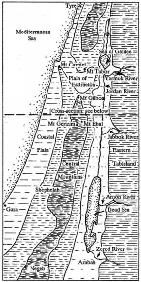
The main physical features of Palestine ran approximately north-south in more or less parallel lines. Bordering the Mediterranean Sea was a coastal plain rising into an area of low foothills called the Shephelah, which rose further into the broad central mountains. These mountains then fell away into a deep valley called the Arabah, through the northern section of which flowed the Jordan River. East of Jordan the land rose sharply, then opened on to an uneven tableland. (For Palestine’s vegetation, animal life, climate and agriculture see ANIMALS; BIRDS; FARMING; FLOWERS; FOOD; TREES; WEATHER.)
Coastal plain
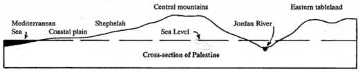
Palestine’s coastal plain, from the Phoenician town of Tyre in the north to the Israelite town of Gaza in the south, was about 220 kilometres in length. In Phoenicia, where the Lebanon Range was close to the coast, the plain was very narrow (see LEBANON; PHOENICIA), but south from Lebanon it gradually widened till interrupted by the Mt Carmel Range.
Extending inland from the Mt Carmel Range to Jezreel was the Plain of Esdraelon, through which flowed the Kishon River (Jdg 5:21; Hos 1:5). From Jezreel the plain led into the Valley of Jezreel, which extended east as far as the town of Bethshan near the Jordan River. Other towns of the region were Jokneam, Megiddo, Ibleam and Shunem (Jos 17:11; 1Sa 28:4; 1Ki 4:12). (For details of towns mentioned in this article see entries under the names of the towns.)
This whole area (i.e. the Plain of Esdraelon and the Valley of Jezreel) was sometimes referred to as the Valley of Jezreel and played an important part in Israel’s history. To the north of the valley was Mt Tabor, and to the south Mt Gilboa. Many of Israel’s battles were fought in this area, partly because the main north-south (Syria to Philistia) and east-west (Bethshan to Mt Carmel) roads passed through the valley. Megiddo, where the two roads crossed, also commanded the western entrance to the Plain of Esdraelon and consequently was of strategic importance to Israel (Jdg 4:6; Jdg 5:19-21; Jdg 6:33; 1Sa 29:1; 1Sa 31:1; 1Sa 31:8; 1Sa 31:12; 2Ki 9:16; 2Ki 9:27; 2Ki 9:30; 2Ki 23:29; Zec 12:11).
Along the coast immediately to the south of Mt Carmel was the small Plain of Dor (Jos 17:11; 1Ch 7:29) and farther south the larger Plain of Sharon. Though much of Sharon was marshy, it had some pastoral and forestry lands. In Old Testament times it was fairly thinly populated (1Ch 27:29; Song of Son 2:1; Isa 35:2).
Because of sandy shores and shallow waters, there were no good sites for harbours south of Mt Carmel. A low headland enabled a small harbour to be built at Joppa, and in Old Testament times this was Israel’s only Mediterranean port. Other towns in the area were Ono and Lod (or Lydda) (2Ch 2:16; Ezr 3:7; Neh 11:35; Jon 1:3; Act 9:35-36; Act 9:38; Act 10:5-8). In New Testament times the magnificent city of Caesarea, built by Herod the Great and equipped with an artificial harbour, became the administrative centre and chief port of the Roman province of Judea (Act 18:22; Act 25:1-6).
From Joppa south to Gaza was the Plain of the Philistines, whose five main towns were Ekron, Ashdod, Ashkelon, Gaza and Gath. The plain and its lowland hills were good for farming, but became drier and less fertile towards the south. (For further details of this region see PHILISTIA.)
Shephelah
The low hill country between the narrow coastal plain and the high central range was called the Shephelah (Deu 1:7; Jos 9:1-2; Jos 10:40; Jos 12:8; Jer 17:26; Oba 1:19). It consisted of many hills and valleys, down which flowed swift mountain streams. This produced a fertile region that was suitable for growing sycamore trees and raising sheep and cattle (1Ki 10:27; 1Ch 27:28; 2Ch 9:27; 2Ch 26:10).
Certain valleys in the Shephelah provided the only convenient routes from the coastal plain up to the central highlands, and consequently were the scene of many battles. The most important of these valleys was the Valley of Aijalon, where the main route from the coastal plain climbed up through Gezer and Beth-horon to the chief highland towns (Jos 10:11-12; Jos 16:3; 1Ki 9:16-17; see ‘Central mountains’ below).
To the south of the Valley of Aijalon was the Valley of Elah leading up through Libnah (Jos 10:29-31; 1Sa 17:2; 2Ki 19:8), and slightly farther south another valley leading up through Lachish (2Ki 18:13-17). Of lesser importance were the valleys of Sorek and Zephathah (Jdg 16:4; 2Ch 14:10).
Central mountains
Rising from the coastal plain/Shephelah on the west and the Jordan Valley/Arabah on the east were the central mountains of Palestine. For convenience they may be considered a single mountain range broken into two unequal sections.
The smaller northern section consisted mainly of the mountains of Galilee and was separated from the remaining section by the Plain of Esdraelon and its associated Valley of Jezreel. These hills and the adjacent plain and valley covered much of the tribal areas of Dan, Naphtali, Issachar, Zebulun and Asher (Jos 20:7; Isa 9:1).
In the north of Galilee the mountains were higher than those in the south, more thickly forested and more thinly populated. In Old Testament times the chief city of the northern part was Hazor, originally a Canaanite stronghold but later one of Israel’s northern defence outposts (Jdg 4:2; 1Ki 9:15). Towards the south the mountains were more suited to farming. This south Galilean hill country was the region where Jesus grew up and where he spent most of the three and a half years of his public ministry. Some of the towns of the region were Nazareth, Cana and Nain (Mat 21:11; Luk 2:39; Luk 4:16; Luk 7:11; Joh 2:1-11; Joh 4:46; Joh 21:2). (For other towns in Galilee see ‘Upper Jordan and Sea of Galilee’ below.)
Hills to the south of the Plain of Esdraelon marked the beginning of the long section of the range that stretched through central and southern Palestine. First were the hills of Samaria. These were not as high as those of north Galilee, the only prominent mountains being Mt Gerizim and Mt Ebal, which stood on opposite sides of the town of Shechem (Deu 27:12-13; Jdg 9:7). Other important towns were Tirzah and Samaria. In the early days of the divided Israelite kingdom, Tirzah was the northern capital (1Ki 14:17; 1Ki 15:33; 1Ki 16:6-8; 1Ki 16:15-19). Samaria was made the capital after Tirzah and remained so till the end of the northern kingdom. The city’s position on a hill overlooking the surrounding territory made it an excellent site for a capital (1Ki 16:23-24; 1Ki 20:1; 2Ki 6:24; 2Ki 17:5). North of Samaria was the small Plain of Dothan, which provided an alternative route from Jezreel to the coast (Gen 37:17; Gen 37:28; 2Ki 6:13).
Further south was the hill country of Ephraim, Benjamin and part of neighbouring Judah. This was a fertile forest region broken by steep valleys. These valleys proved to be good defences against attackers, particularly in the days after Joshua’s conquest when the Israelites were struggling to keep hold of their newly won territory (Jos 17:17-18; Jdg 5:14; Jdg 7:24; Jdg 12:15).
To the west the Valley of Aijalon led down from the towns of Beth-horon and Gezer through the Shephelah to the Philistine coastal plain (Jos 10:9-12; Jos 16:3; Jos 16:5; Jos 18:13-14). Since this valley provided a main route from the coastal plain to Israel’s highlands, it was a frequent battlefield and became well fortified with Israelite defence outposts (1Sa 13:17-18; 1Ki 9:16-17; 2Ch 8:5; 2Ch 11:10; 2Ch 25:13; 2Ch 28:18).
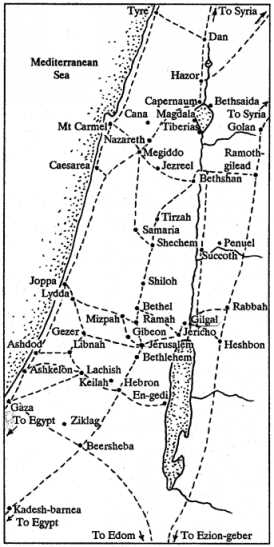
On the other side of the highlands another valley provided the way down to the east. The route went from Bethel through Ai and Michmash to Jericho on the broad plain of the Jordan Valley (Jos 16:1-2; Jos 18:11-13; 1Sa 13:2-5; 1Sa 13:23; 1Sa 14:1-5; Luk 10:30; Luk 19:1).
This part of the central highlands was one of the most thickly populated regions of Canaan. Some of its other well known towns were Shiloh, Mizpah, Ramah, Gibeon, Gibeah, Kiriath-jearim, Beth-shemesh, Emmaus, Jerusalem, Bethlehem and Bethany (Jos 9:3; Jos 9:17; Jos 18:25-28; 1Sa 6:12; 1Sa 7:15-17; 1Sa 14:1-3; 1Sa 17:12; Mat 2:1; Mar 11:1; Luk 24:13).
To the south of this collection of towns the hills gradually flattened, the rainfall decreased, the land became less fertile and the population was more thinly spread. The chief town in this region was Hebron (Gen 23:17-19; 2Sa 2:11; 2Sa 3:20; 2Sa 15:10). It was situated about half way between Jerusalem and Beersheba and was on the main route from Jerusalem to Egypt (Num 13:21-22).
Another route led west from Hebron through Lachish down to Ashkelon and Gaza on the main coastal route to Egypt. Because of their strategic positions, Hebron and Lachish were heavily fortified (2Ch 11:5-12).
This barren region of southern Judah was the place to which David fled in escaping from Saul. Some of the places mentioned in the story are Adullam, Keilah, Ziph, En-gedi, Maon, Horesh and Ziklag (1Sa 22:1; 1Sa 23:13-15; 1Sa 23:25; 1Sa 23:29; 1Sa 24:1-2; 1Sa 25:1-2; 1Sa 27:6-10; for map see DAVID). The central mountains had by now flattened into a broad tableland that stretched south into the Negeb.
Negeb
The Negeb is literally ‘the dry’, and was the name given to the dry southern part of Palestine between the Dead Sea and the Sinai Desert. Its approximate northern boundary ran from Gaza on the coast east to the Dead Sea. Its approximate southern boundary ran from Ezion-geber at the north-eastern tip of the Red Sea to the Brook of Egypt (Wadi El-Arish), which it followed to the coast. The chief towns of the Negeb were Beersheba in the north and Kadesh-barnea in the south. The Wilderness of Zin fell within the Negeb, and the Wildernesses of Shur and Paran bordered it to the west and south respectively (Gen 20:1; Exo 15:22; Num 10:12; Num 13:26; Num 20:1; Num 32:8; Num 33:35-37; Num 34:4).
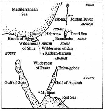
In Old Testament times much of the Negeb was occupied by the tribe of Judah. The northern part attracted more people than the southern, because it was more suitable for grazing and farming. The Philistines continued to occupy much of the coastal plain, and other tribal groups occupied various areas at different times (Gen 20:1; Gen 26:1; Num 13:29; 1Sa 27:10; 1Sa 30:14). Water was always a problem in this dry region (Gen 16:7; Gen 26:17-23; Jos 15:19).
Two main roads linked Egypt and Palestine. The ‘Way of the land of the Philistines’ went along the coast (Exo 13:17), the ‘Way of the Wilderness of Shur’ went through the centre of the Negeb (Gen 16:7). This latter route passed through the towns of Kadesh-barnea, Beersheba, Hebron, Jerusalem, Shiloh and Shechem, and was a well used route even as early as the time of Abraham (Gen 20:1; Gen 21:32; Gen 37:14; Gen 46:1). It may have been used by some of the twelve spies when they went north to spy out Canaan (Num 13:21-23), and was probably used by Joseph and Mary when they fled to Egypt to escape from Herod (Mat 2:13-15).
This north-south road was crossed at Beersheba by a west-east road connecting Gaza on the coast with Edom inland. The section of the road that went east from Beersheba through the Valley of Salt and the Wilderness of Zin to Edom was known as the ‘Way of the Wilderness of Edom’ (2Sa 8:13; 2Ki 3:8; 2Ki 14:7).
Upper Jordan and Sea of Galilee
The Jordan River rose in the region of Mt Hermon in the Lebanon Range. From there it flowed south through a region that was quiet and isolated, till the tribe of Dan conquered the people and seized the territory for itself. In Old Testament times the town of Laish, which the Danites renamed Dan, became the northernmost town of Israel (Jdg 18:27-29; 1Sa 3:20; 1Ki 12:29). In the New Testament record the town of Caesarea Philippi, which was in the same locality, was the northernmost point that Jesus visited (Mat 16:13).
South of Dan the Jordan flowed through a small lake, then into a second and larger lake known in the Old Testament as the Sea of Chinnereth and in the New Testament as the Sea (or Lake) of Galilee, the Lake of Gennesaret, and the Sea of Tiberias (Num 34:11; Mat 15:29; Luk 5:1; Joh 6:1). The hills around the Sea of Galilee, particularly those to the north-west, provided Jesus with some quiet spots where he went to pray and teach his disciples (Mat 5:1; Mat 14:23; Mat 15:29; Mat 28:16).
The lake itself was 200 metres below sea level and contained plenty of fish (Mat 4:18; Luk 5:1-9; Joh 21:1-8). The area around the lake was well populated and was the scene of much of Jesus’ public ministry. On the northern shore of the lake were two towns, each with a large Jewish population, Capernaum and Bethsaida. Capernaum seems to have been Jesus’ base for his northern ministry (Mat 4:13; Mar 2:1; Mar 6:45; Mar 9:33; Joh 6:17). In the hills behind Capernaum was another town that Jesus visited, Chorazin (Mat 11:21-23).
On the western shore of Lake Galilee were the largely Gentile towns of Magdala and Tiberias. Also bordering the lake to the west was the small Plain of Gennesaret (or Chinnereth) (Mat 15:39; Mar 6:53; Joh 6:23).
To the east of the lake was the less populous district of Gadara, where the land rose steeply from the water’s edge and opened on to good farming country. The people of the district were mainly Gentiles, some of them pig farmers, and were known as Gadarenes (after the local district) or Gerasenes (after the larger district where Gadara was located) (Mat 8:28; Mat 8:30-32; Mar 5:1; Mar 5:11-13). Spreading out farther to the north and east was the rich pastoral land of Bashan. Two of its main towns were Golan and Edrei (Deu 32:14; Jos 12:1-5; Jos 21:27; Jer 50:19; see BASHAN).
Jordan Valley and Dead Sea
From the Sea of Galilee the Jordan flowed south through a deep valley till it entered the Dead Sea, 400 metres below sea level. The valley immediately south of the Sea of Galilee was fertile and good for farming, but further south it began to become desolate, till it was little better than a desert where the Jordan entered the Dead Sea (Mar 1:4-5; Mar 1:9-13).
For much of its length the river was difficult to cross, and so formed a good barrier against invasion from the east. There was thick jungle along the water’s edge on either side of the river, from where steep banks rose up to the floor of the main valley (Jer 12:5; Jer 49:19; Zec 11:3). These banks collapsed at times and damned the stream, which was probably what happened at the time of Israel’s crossing under Joshua (Jos 3:14-17). Normally, people could cross the river only at certain places where there were natural fords (Jos 2:7; Jdg 3:28; Jdg 7:24; Jdg 12:5; 2Sa 19:15; 2Sa 19:18).
Between the Sea of Galilee and the Dead Sea a number of streams fed the Jordan from the east, the most important of them being the Yarmuk and the Jabbok. Another, of lesser importance, was the Cherith (Deu 3:16; 1Ki 17:3). Two towns of the region, Succoth and Penuel, were strategically located close to the Jordan and Jabbok Rivers. A ford crossed the Jordan nearby, and defence fortifications were built at Penuel (Gen 32:22; Gen 32:31; Gen 33:17; Jdg 8:8; Jdg 8:16-17; 1Ki 12:25).
The region east of Jordan, particularly the central part, was commonly known as Gilead. In the time of Moses, Israel had taken the land from the Amorites, but the earlier occupants were the Ammonites (in the central region) and the Moabites (in the southern region). Their respective capitals were Rabbah and Heshbon (Num 21:24-26; Deu 3:11; Deu 4:46). The Israelites’ chief defence outpost on the eastern frontier was at Ramoth-gilead (2Ki 8:28; 2Ki 9:14). (For maps and other details see AMMON; GILEAD; MOAB.)
In the Jordan Valley and to the west of the river were the towns of Gilgal and Jericho (Jos 4:19). Because of a natural spring of freshwater at Jericho, the town had the appearance of an oasis and was called the city of palm trees (Deu 34:3). Another natural product of the Jordan Valley was a special kind of clay that was used in making articles of bronze (1Ki 7:46).
The Dead Sea was known also as the Salt Sea, because of the large amounts of salt and other chemicals in the water (Jos 15:5; Jos 18:19). No fish could live in it and no vegetation grew around its shores, except at places where fresh water entered from streams on the eastern side. There were no streams on the western side, but cultivation was possible at isolated points where there were freshwater springs, such as at En-gedi (Song of Son 1:14).
It is believed that Sodom and Gomorrah were located near the southern end of the Dead Sea. Through earthquake activity the sea apparently spread further south, covering whatever may have remained of the ancient cities (Gen 19:24-28).
Arabah
From the eastern side of the central highlands, the land fell away sharply into a deep valley that ran from the Sea of Chinnereth (Sea of Galilee) along the Jordan River to the Dead Sea, from where it continued south to Ezion-geber on the Gulf of Aqabah (the north-eastern arm of the Red Sea). The section north of the Dead Sea was commonly known as the Jordan Valley, and the section south as the Arabah.
Originally, arabah was a common Hebrew word meaning ‘burnt’ or ‘dried up’, and was used of dry or semi-desert wasteland. It was a fitting word to give as a name to the barren valley south of the Dead Sea (Deu 1:1; Deu 2:8).
The name Arabah was not restricted to this one region. On occasions the whole valley, both north and south of the Dead Sea, was called the Arabah. The Dead Sea was known as the Sea of the Arabah, and a small stream that entered the Jordan near its entrance to the Dead Sea was known as the Brook of the Arabah (Deu 3:17; Deu 4:48-49; Jos 3:16; Jos 11:2; Jos 12:1-3; Amo 6:14). In the days of Israel’s expansion under Jeroboam II, the Sea of the Arabah marked Israel’s southern boundary (2Ki 14:25).
An important road called the King’s Highway ran from Ezion-geber along the plateau on the eastern side of the Arabah through Edom, Moab and Ammon into Syria. The Israelites under Moses wanted to use this road on their journey to Canaan, but Edom and Moab refused permission, forcing the Israelites to make a lengthy and tiring detour around the borders (Num 20:14-21; Num 21:10-13; Num 21:21-26; Jdg 11:15-24).
The Arabah contained good quantities of iron and copper (Deu 8:9). Workers mined and smelted the minerals at various places along the valley, then transported them down the King’s Highway (the Arabah road; Deu 2:8) to a refinery at Ezion-geber, from where large ocean-going ships carried them east (cf. 1Ki 9:26-28; 1Ki 10:22).
Political divisions
For details of the history of Palestine and its political divisions in Old Testament times see AMORITES; CANAAN; ISRAEL; JUDAH, TRIBE AND KINGDOM; and articles under the names of the various Israelite tribes and towns. In New Testament times there were three commonly recognized regions in Palestine itself (northern, central and southern; see GALILEE; SAMARIA; JUDEA), and two in the former Israelite territory to the east of Jordan (northern and southern; see DECAPOLIS; PEREA).
A country on the eastern shore of the Mediterranean Sea, also known as Canaan and Israel.
Palestine is at the western end of a curved strip of rich farmland called the "Fertile Crescent." This fertile land stretched from the Persian Gulf through Mesopotamia and Syria, all the way to Egypt. The soil here was very good for growing crops.
Palestine's location made it very important in ancient times. It formed a natural bridge of land between two major ancient centers of culture, Mesopotamia and Egypt. It also connected the continents of Asia, Africa, and Europe.
Many trade routes passed through Palestine. Merchants used these routes to carry goods from distant places like northern Europe, India, and southern Egypt. These same roads were later used by armies who wanted to gain control of the region and its wealth.
This land was very important in religious history. According to the Bible, God promised this land to Abraham and his descendants. It became the homeland of the Jewish people, and many events in the Bible took place here. Today, Palestine is sacred (holy) to three major world religions: Judaism, Christianity, and Islam.
Palestine has many different types of land and weather in a small area. Within just 241.4 kilometers (150 miles), you can find almost every kind of environment on Earth:
Fertile plains good for farming
Sandy deserts
Rocky areas
Forests
Mountains
Lakes
Rivers
These different environments create strong contrasts. In the north, Mount Hermon is so high (2,773.7 meters or 9,100 feet) that it always has snow on its peak. About 160.9 kilometers (100 miles) away, the Dead Sea sits in a warm valley. This is the lowest point on Earth's surface.
Preview
• Name
• Climate
Name
This land has had many different names throughout its history. Most foreign traders first came to know the area through its coastal region. This is probably why the whole land was first called Canaan and later Palestine (named after a region called Philistia).
According to the Bible's record of ancient peoples (the Table of Nations), the land of Canaan stretched from Sidon in the north to Gerar and Gaza in the south and east to the Cities of the Plain (Genesis 10:19). The first time the Bible uses "Canaan" as the name for this region is in Genesis 11:31.
After the Israelites took control of Canaan, people began calling it the land of Israel (1 Samuel 13:19; 1 Chronicles 22:2). Then around 930 BC, during King Rehoboam's rule, the land divided into two kingdoms:
The northern kingdom kept the name Israel.
The southern kingdom was called Judah (later known as Judea).
Territory
The Bible first describes Palestine's size in God's promise to Abraham and his descendants (Genesis 15:18–21). The borders stretched from the River of Egypt (Wadi el-Arish) in the southwest to the Euphrates River in the northeast. This area was home to ten groups of people:
Kenites
Kenizzites
Kadmonites
Hittites
Perizzites
Rephaim
The Amorites
Canaanites
Girgashites
Jebusites.
In Genesis 17:8, the whole area is simply called "all the land of Canaan."
God gave Moses more specific instructions about the borders of the land Israel would live in (Numbers 34:1–12). The southern border stretched from the River of Egypt, south of Kadesh-barnea, and followed the wilderness of Zin to the southern tip of the Dead Sea. The western border was the Mediterranean Sea. The northern border was near the entrance to Hamath, and the Jordan River and the Dead Sea marked the eastern border.
The largest area that the promised land ever occupied is described in Exodus 23:31. God told Moses he would set Israel's boundaries from the Red Sea to the Mediterranean Sea and from the wilderness to the Euphrates River.
During the early period when judges led Israel, and later when Saul was king, the Israelites did not control all the land that had been given to their tribes under Joshua's leadership. This changed during the time of two later kings, David and Solomon.
King David used military power to expand Israel's borders. He efeated King Hadadezer of Zobah, pushing the northern border to the Euphrates River. He won battles against Syria, Ammon, Moab, Edom, and Amalek. David made the kingdom larger to the east and south (2 Samuel 8:1–14; 1 Chronicles 18:1–13).
King Solomon used peaceful diplomacy to maintain and expand the kingdom. He had trading ships at Ezion-geber on the Gulf of Aqaba. He started copper mining operations in that area.
Climate
Palestine has many different types of weather in a small area. It has more different kinds of weather (climate) than any other place of similar size in the world. The weather is generally mild, but it varies in different parts of the country.
In Jerusalem, temperatures can range from negative 3.3°C (26°F) to 41.6°C (107°F). The area gets about 50.8 centimeters (20 inches) of rain each year. The coastal plain is warmer and humid all year. In the city of Joppa, the average temperature is 19.4°C (67°F). The Jordan Valley near the Dead Sea is subtropical, with summer temperatures reaching up to 48.8°C (120°F).
Rainfall is seasonal, with most rain falling during the cooler months, from October to April. The rest of the year is usually dry. This happens because wet winds blow from the west. When these winds reach the cooler land, they drop their moisture as rain. Moist winds from the west bring rain over the colder land, similar to the "lake effect" snow seen near the Great Lakes in the United States. The Bible mentions two rainy periods (Jeremiah 5:24; Joel 2:23):
The "former rain" in October and November
The "latter rain" from March to April
Different areas get different amounts of rain each year. The coastal area receives about 71.1 centimeters (28 inches) of rain each year. The country’s overall average is 55.9 to 70 centimeters (22 to 24 inches).
Geography
Palestine can be divided into five main regions that run from north to south:
The Maritime or Coastal Plain, which is the land along the Mediterranean Sea
The Shephelah, a region of low hills
The Western Plateau or Hill Country, a high plateau of mountains and hills
The Jordan Valley, a deep valley (also called the Arabah)
The Eastern Plateau, the high land east of the Jordan River (also called Transjordan)
The Maritime or Coastal Plain
The Coastal Plain can be divided into three areas from south to north: the plain of Philistia, the plain of Sharon, and the plain of Acre.
The plain of Philistia stretches from the Wadi el-Arish (also called the River of Egypt) in the south to about 8 kilometers (five miles) north of Joppa. It is around 112.6 kilometers (70 miles) long and widest near Gaza, measuring 48.3 kilometers (30 miles) across. This plain, mostly fertile, was ideal for growing grain.
The plain of Sharon lies north of the Philistine plain. It was likely under Philistine control. The Old Testament recognizes it as separate from Philistine lands (see Song of Solomon 2:1; Isaiah 65:10). This plain extends north to Mount Carmel and includes the towns of Dor and Caesarea.
The plain of Acre starts beyond Mount Carmel, near the city of Ptolemais (also known as Acre or Acco), mentioned in Acts 21:7 and Judges 1:31. This narrow plain stretches about 32.2 kilometers (20 miles) to the Ladder of Tyre (Ras en-Nakurah). The Kishon River (Judges 4:7, 13; 1 Kings 18:40) flows through this area.
The Shephelah
The Shephelah is a region between the low coastal plain and the highlands of the Western Plateau. Its elevation is around 152.4 to 304.8 meters (500 to 1,000 feet), and it is only a few miles wide. It extends from the valley of Aijalon to Beersheba. The valleys in the Shephelah were good for growing grain, while the hills were good for growing vineyards and olive trees. This area was important strategically because it provided access to Jerusalem.
The Western Plateau or Hill Country
The Western Plateau or Hill Country rises to an elevation between 304.8 to 609.6 meters (1,000 and 4,000 feet). It extends about 241.4 kilometers (150 miles) from Lebanon in the north to Beersheba in the south. This region can be divided into three parts: Galilee, Samaria, and Judea.
Galilee is divided into Upper Galilee, with elevations from 609.6 to 1,219.2 meters (2,000 to 4,000 feet), and Lower Galilee, below 609.6 meters (2,000 feet). It was a region mostly used for farming and open to invasion. Its location made Galilee a diverse and culturally mixed area, referred to as “Galilee of the nations” in Isaiah 9:1.
Samaria was another area that was good for growing crops and keeping livestock. Joseph’s brothers were grazing their sheep in the plain of Dothan when they plotted against him (Genesis 37:17).
Judea is about 609.6 to 1,066.8 meters (2,000 to 3,500 feet) above sea level and stretches around 96.5 kilometers (60 miles) from Bethel to Beersheba. Jerusalem, located in Judea, sits at 808.9 meters (2,654 feet). Surrounded by mountains and valleys, Jerusalem had natural defenses (Psalm 125:2). Jerusalem became Israel's religious center and capital when David moved the ark of the covenant there. As prophesied, Jerusalem became the center of worship when Solomon built the temple, one of the era's most impressive buildings.
The Jordan Valley or the Arabah
The Jordan Valley (also called the Arabah) has both the highest and lowest points in Palestine. Mount Hermon, at 2,793.8 meters (9,166 feet), is the highest point. The Dead Sea's surface is 395 meters (1,275 feet) below sea level. Its deepest point goes down another 396.2 meters (1,300 feet).
The North Arabah (or Upper Jordan Valley) is where the Jordan River begins near Mount Hermon. The river has four different starting points (sources). It flows through the former Lake Huleh (now partly drained and made into a wildlife refuge). The Bridge of Jacob’s Daughters, which crosses the Jordan on the road to Damascus, is located 3.2 kilometers (2 miles) below Huleh. The river then moves through a 1,200-foot (365.8-meter) gorge.
The Sea of Galilee is located about 16.1 kilometers (10 miles) from Lake Huleh. It sits at an elevation of negative 208.8 meters (negative 685 feet). It spans 24.1 kilometers (15 miles) in length and 12.9 kilometers (8 miles) in width, with a maximum depth of 228.6 meters (750 feet). Its shape inspired its Old Testament name, Chinnereth, meaning "harp" (Numbers 34:11; Joshua 13:27). In the New Testament, it was called the Lake of Gennesaret (Luke 5:1) and the Sea of Tiberias (John 6:1; 21:1).
The Middle Arabah (or Ghor) contains the Jordan River. The name Jordan means "descender." The Jordan River covers about 96.5 kilometers (60 miles) in a straight line from the Sea of Galilee to the Dead Sea. This part of the river's course drops over 182.9 meters (600 feet), flowing in a series of sharp back-and-forth turns. The actual length of the river is 321.8 kilometers (200 miles).
This stretch of the Jordan Valley is known as the Ghor or Rift. The Yarmuk River enters the Jordan from the east from 9.7 kilometers (six miles) below the Sea of Galilee. Some smaller streams empty into the Jordan, but the next important river is the Jabbok (Genesis 32:22). The Ghor, just south of the Sea of Galilee, is about 6.4 kilometers (four miles) wide. Near Beth-shan, it reaches 11.3 kilometers (seven miles) wide. Beyond that, for around 24.1 kilometers (15 miles), the mountains are close to the river, making the valley 3.2 to 4.8 kilometers (two to three miles) wide. Near Jericho, it expands to about 19.3 kilometers (12 miles) wide.
The Dead Sea is a unique region. It is the deepest point on Earth. The Dead Sea is also known as the "Salt Sea" (Genesis 14:3; Numbers 34:12; Joshua 12:3) or the "Sea of Arabah" (Joshua 12:3). Josephus calls it "Lake Asphaltitis."
It is 74 kilometers (46 miles) long and 16.1 kilometers (10 miles) wide and 396.2 meters (1,300 feet) deep. With a mineral content of about 25 percent, it is a valuable chemical deposit. The Dead Sea receives water from the Jordan and other streams, such as the Arnon River on the east. Much of the runoff of seasonal rains also collects into the Dead Sea. Summer temperatures can reach 48.8°C (120°F), with extreme humidity. The sea experiences 5.4 to 7.3 million metric tons (6 to 8 million tons) of daily evaporation.
The Southern Arabah is a mostly barren region. It stretches from the Dead Sea to the Gulf of Aqaba, spanning 241.4 kilometers (150 miles). The Arabah rises from its lowest point, the Dead Sea, to its highest, a watershed just west of Petra. Ports like Elath (modern Eilat) and Ezion-geber were located at its southern tip.
The Eastern Plateau or Transjordan
The Eastern Plateau (or Transjordan) was not part of the promised land. The tribes of Reuben, Gad, and half of Manasseh claimed it. It had better water resources than the Western Plateau, with permanent streams such as the Yarmuk, Jabbok, and Arnon. The King's Highway, a key north-south route, passed through this region. It is mentioned in the Israelites' journey during the Exodus (Numbers 21:22). It was probably also the route taken by the invading kings of Genesis 14.
The northern section of Transjordan was known as Bashan. It was famous for its cattle and oak trees (Psalm 22:12; Ezekiel 39:18; Isaiah 2:13; Zechariah 11:2).
Gilead was an area east of the Jordan River. It was well-known in ancient times for making a healing medicine called balm (Genesis 37:25; Jeremiah 8:22), The Bible mentions Gilead many times (for example, in Deuteronomy 3:10–16 and Judges 11). The region of Gilead stretched from the Yarmuk River to Heshbon. In David's time, it was covered with thick forests (2 Samuel 18:8).
In Palestine proper, two areas are especially important:
The Plain of Esdraelon was known for its fertile lands and historical battles. This plain lies between Galilee and Samaria. It is often associated with Armageddon and was guarded by fortress cities like Megiddo, Ibleam, and Taanach. In the Old Testament, the Jezreel Valley was considered separate from Esdraelon. At the eastern end was the stronghold of Beth-shan.
In the far south of Palestine lies a dry wilderness area called the Negev (also known as the South Country). This region extends from Beersheba to Kadesh-barnea. It does not rain often so it is difficult to grow crops there. But, the region has long been used mainly by nomadic shepherds who move around with their animals.
See Arabah; Conquest and Allotment of the Land; Dead Sea; Decapolis; Sea of Galilee; Jordan River; Negev; Shephelah; Transjordan.
Aquifer Open Bible Dictionary © 2026 Mission Mutual, an adaptation of the Tyndale Open Bible Dictionary © 2023 Tyndale House Publishers. Licensed under CC BY-SA 4.0.